A Rectangular-Like Guided Segmentation Method for Cornfield Remote Sensing Images

A remote sensing image and cornfield technology, applied in the field of agricultural remote sensing image segmentation, can solve the problem of unsatisfactory segmentation results and achieve good segmentation results and good continuity

Inactive Publication Date: 2018-04-13
ZHONGBEI UNIV
View PDF0 Cites 0 Cited by
  • Summary
  • Abstract
  • Description
  • Claims
  • Application Information

AI Technical Summary

Problems solved by technology

[0005] In order to solve the problem of unsatisfactory segmentation results when the traditional segmentation method is applied to cornfield remote sensing image segmentation, the present invention provides a cornfield remote sensing image segmentation method guided by a rectangle

Method used


Image

  • A Rectangular-Like Guided Segmentation Method for Cornfield Remote Sensing Images
  • A Rectangular-Like Guided Segmentation Method for Cornfield Remote Sensing Images
  • A Rectangular-Like Guided Segmentation Method for Cornfield Remote Sensing Images

Examples


Embodiment Construction

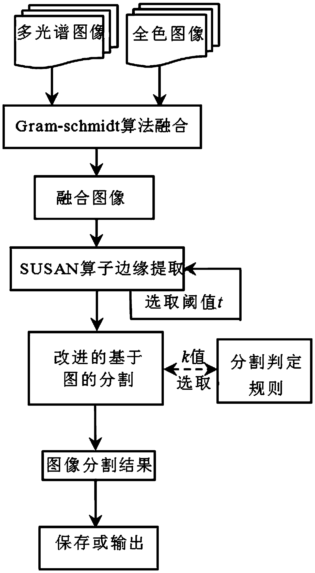
[0029] The present invention will be described in detail below in conjunction with the accompanying drawings, taking a certain corn planting area in Lantian County, Shaanxi Province in the GF-1 satellite digital remote sensing image as an example, using the present invention to segment it and count the corn reference standard area. A method for segmenting cornfield remote sensing images guided by a rectangle, comprising the following steps:

[0030] S1: Use the Gram-schmidt transformation to fuse the 2-meter panchromatic data and the 8-meter multispectral data of the original GF-1 to obtain a fused image, improve the spatial resolution of the multispectral band, and enhance the clarity and interpretation of the image. image 3 Fusion image for GS;

[0031] S2: Set a 5×5 square detection template with each pixel in the fused image as the center, until all pixels in the fused image are traversed, and then calculate the gray level difference between each pixel in each template an...


PUM


Abstract

The invention relates to an agricultural remote-sensing image segmentation technology, in particular to a near-rectangle guide based remote-sensing cornfield image segmentation method. The method includes: subjecting a fused satellite remote-sensing image to edge extraction by an SUSAN (small univalue segment assimilating nucleus) operator, then constructing a near-rectangle guide based correlation function according to a relation between a closed region and a circumscribed near-rectangle, and importing a near-rectangle threshold function into an image-based segmentation algorithm to segment a field in a specific shape. According to the method, a satisfactory segmentation result can be obtained to better conform to an actual cornfield area statistic result, and over-segmentation patches of boundary regions due to a same object with different spectra are decreased. The near-rectangle guide based remote-sensing cornfield image segmentation method is mainly used for remote-sensing measurement of large-area corn planting area.

Description

technical field [0001] The invention relates to an agricultural remote sensing image segmentation technology, in particular to a method for segmenting a cornfield remote sensing image guided by a rectangle. Background technique [0002] With the development of remote sensing technology and the improvement of satellite spatial resolution, remote sensing technology has become an important scientific and technological means in crop production management, and the extraction of crop information is the key to the application of remote sensing technology in crop research. Image segmentation is the basis of remote sensing information extraction of crops. It can effectively use the spectral characteristics, structural information and geometric information of images to obtain ideal segmentation results, which is the premise of crop identification and classification. [0003] Remote sensing measurement of corn planting area is an important aspect of the application of crop remote sensi...

Claims


Application Information

Patent Timeline
Patent Type & Authority Patents(China)
IPC IPC(8): G06T7/11G06T7/12G06T7/136
CPCG06T7/12G06T2207/10032G06T2207/30188
Inventor 杨风暴李大威梁若飞冯裴裴张树斌许多秦健云翟煜琪闫鑫龙
Owner ZHONGBEI UNIV
Why Eureka
Try Eureka