Unmanned aerial vehicle assisted vehicle-mounted road acquisition three-dimensional modeling system and realization method thereof

A technology of 3D modeling and realization method, applied in 3D modeling, image data processing, measuring devices, etc., can solve problems such as insufficient collection of road information, inability to establish a 3D model of a tunnel, and inability to realize positioning, and achieve data processing automation High degree, low project development cost, and the effect of saving project development cost

Active Publication Date: 2015-10-21
TUNNEL TANG TECH
View PDF6 Cites 29 Cited by
  • Summary
  • Abstract
  • Description
  • Claims
  • Application Information

AI Technical Summary

Problems solved by technology

The disadvantage of this method is that the collection of road information is not comprehensive enough, for example, substructures such as bridge piers and columns cannot be collected, so the modeling is not accurate enough
[0005] In addition, the above two solutions require the use of satellite positioning systems such as GPS or Beidou navigation. For areas without satellite signals in the tunnel, positioning cannot be achieved, so it is impossible to establish a 3D model in the tunnel

Method used


Image

  • Unmanned aerial vehicle assisted vehicle-mounted road acquisition three-dimensional modeling system and realization method thereof
  • Unmanned aerial vehicle assisted vehicle-mounted road acquisition three-dimensional modeling system and realization method thereof
  • Unmanned aerial vehicle assisted vehicle-mounted road acquisition three-dimensional modeling system and realization method thereof

Examples


Embodiment

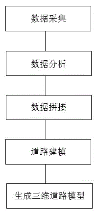
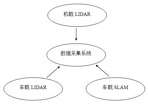
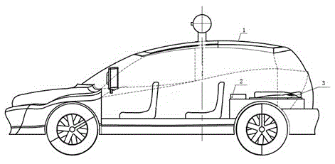
[0038] Such as figure 1 , 2 , 3, this embodiment provides a UAV-assisted vehicle-mounted road acquisition three-dimensional modeling system, the modeling system is mainly based on the carrier vehicle and its subsystems, and the UAV and its subsystems are Auxiliary, the reason is that the carrier vehicle and its subsystems quickly collect road data, and then use the collected data to generate a three-dimensional model of the road. Since the vehicle-mounted road data acquisition system cannot collect substructure information such as pier columns of the bridge, UAVs are used to accurately scan and collect substructure information such as pier columns of the bridge to obtain 3D data of the lower part of the bridge. At the same time, the vehicle-mounted data acquisition module integrates the SLAM system, which can realize accurate positioning of places where satellite signals cannot reach, accurately collect 3D data in the tunnel, and splicing with GPS satellite information outsid...


PUM


Abstract

The invention discloses an unmanned aerial vehicle assisted vehicle-mounted road acquisition three-dimensional modeling system and a realization method thereof, aiming at solving the problems that an existing road acquisition three-dimensional modeling system is not accurate enough, the accuracy is not high and the like. The unmanned aerial vehicle assisted vehicle-mounted road acquisition three-dimensional modeling system comprises a vehicle carrying body; an unmanned aerial vehicle; a data acquisition system comprising a vehicle-mounted LIDAR, a vehicle-mounted SLAM and an airborne LIDAR; a data analysis system for acquiring precision optimized point clouds; a data splicing system for splicing a precision optimized vehicle-mounted LIDAR point cloud, an airborne LIDAR point cloud and SLAM data through a fusion boundary to form integrated positioning information; and a road three-dimensional modeling system for integrating road guardrails, a side slope, an overpass, a bridge lower part, a hillside outside a tunnel and an inner module of the tunnel to form a road three-dimensional model. The unmanned aerial vehicle assisted vehicle-mounted road acquisition three-dimensional modeling system takes the vehicle-mounted LIDAR as a main part and the unmanned aerial vehicle as an assisting part; and the vehicle-mounted LIDAR is combined with the unmanned aerial vehicle so that the comprehensive acquisition of target road data can be realized.

Description

technical field [0001] The invention relates to a road acquisition and three-dimensional modeling system, in particular to a UAV-assisted vehicle-mounted road acquisition three-dimensional modeling system and its implementation method. Background technique [0002] The current road acquisition and 3D modeling system mainly adopts the following two technical solutions: [0003] (1) With the help of shooting satellite images, and then use the captured images to construct a three-dimensional map. The disadvantage of this method is that the processing of the analog data of the image and the construction of the map are very heavy, and the displayed 3D map is difficult to be clear enough and close to reality, and the data cannot be obtained in the tunnel of the road. [0004] (2) The vehicle-mounted system is used to collect road data, and then a three-dimensional model of the road is built according to the collected data. The disadvantage of this method is that the collection ...

Claims


Application Information

Patent Timeline
Patent Type & Authority Applications(China)
IPC IPC(8): G06T17/05G01C7/04
Inventor 申法山张森连朝晖陈守安田彦龙翟建勋张伯南
Owner TUNNEL TANG TECH
Why Eureka
Try Eureka