Quick initial coarse alignment method of inertial navigation system suitable for shipborne communications on the move

An inertial navigation system and coarse alignment technology, which is applied in the field of satellite communication, can solve the problems of not meeting the rapidity requirements of users, long alignment time, and prolonging the initial alignment time of the inertial navigation system, so as to improve the initial coarse alignment accuracy , improved accuracy, fast initial coarse alignment effect

Active Publication Date: 2015-11-11
BEIJING INST OF AEROSPACE CONTROL DEVICES
View PDF5 Cites 10 Cited by
  • Summary
  • Abstract
  • Description
  • Claims
  • Application Information

AI Technical Summary

Problems solved by technology

Swing dynamic alignment can meet the rough alignment in the mooring state of the ship, but this method takes a long time to align, at least 1-2min is needed to complete the rough alignment with a certain accuracy, which will inevitably prolong the initial alignment of the inertial navigation system Time, can not meet the rapidity requirements of users

Method used


Image

  • Quick initial coarse alignment method of inertial navigation system suitable for shipborne communications on the move
  • Quick initial coarse alignment method of inertial navigation system suitable for shipborne communications on the move
  • Quick initial coarse alignment method of inertial navigation system suitable for shipborne communications on the move

Examples


Embodiment

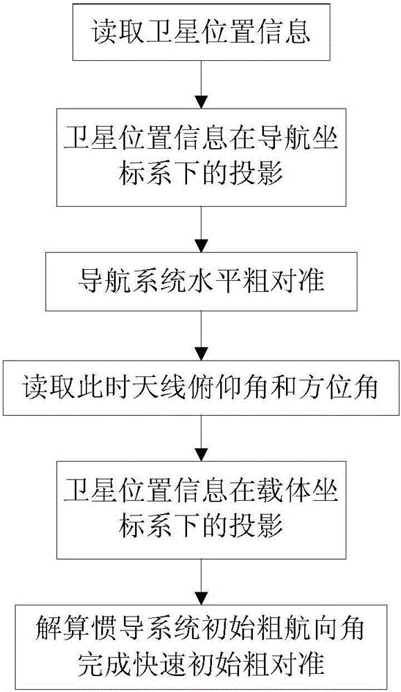
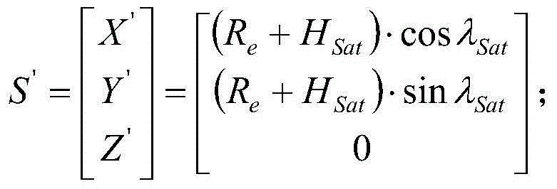
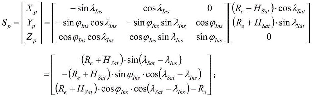
[0055] (1) Set horizontal attitude calculation timer LevelCnt=100ms; read satellite longitude λ Sat = 130°, satellite height H Sat =35786.6km, carrier latitude Carrier longitude λ Ins =116.14°; Calculate the satellite position vector S Sat In the INS geographic coordinate system OX p Y p Z p The projection component S under p : S p = 10099845.83 - 26334228.45 24964670.58 , unit m;

[0056] (2) The horizontal attitude calculation timer LevelCnt starts timing, and simultaneously samples the data of the two horizontal accelerometers of the inertial navigation system for cumulative calculation. When the timer reaches 100ms, calculate the attitude angle P=0.85°, R=0.55°;

[0057] (3) Read the antenna azimuth angle fYaw=267.049° ...


PUM


Abstract

The invention provides a quick initial coarse alignment method of an inertial navigation system suitable for shipborne communications on the move. The method includes the following steps that firstly, satellite position information is read, and a projectional component of a satellite under the geographic coordinate system of the inertial navigation system is computed; secondly, the angle of pitch and the angle of roll of the inertial navigation system is worked out through the accelerometer information in short time; finally, the azimuth angle and the angle of pitch of an antenna are read at this moment, and the projectional component of the satellite under the carrier coordinate system of the inertial navigation system is computed; the course angle of the inertial navigation system is worked out through the projectional component and the angle of pitch and the angle of roll of the inertial navigation system, and quick initial coarse alignment of the inertial navigation system is completed. The method is suitable for initial coarse alignment of the inertial navigation system of the shipborne communications on the move under the mooring state.

Description

technical field [0001] The invention provides a rapid initial rough alignment method for an inertial navigation system suitable for ship-borne mobile communication, which is suitable for occasions requiring fast alignment of satellites in a ship-borne mooring state, and belongs to the technical field of satellite communication. Background technique [0002] When the inertial navigation solution is used for antenna star alignment, the pitch angle P, roll angle R, and heading angle Y information of the inertial navigation system are mainly used to calculate the driving angle of each axis of the antenna through coordinate transformation and drive the antenna to point to the target satellite. . Therefore, the initial alignment time and alignment accuracy of the attitude angle of the inertial navigation system will determine the initial star-seeking accuracy and star-seeking time of the antenna. At present, the initial alignment method in the motion state of the inertial navigat...

Claims


Application Information

Patent Timeline
Patent Type & Authority Applications(China)
IPC IPC(8): G01C25/00
CPCG01C25/005
Inventor 郭涛王盛管伟涛罗强力叶涛何清
Owner BEIJING INST OF AEROSPACE CONTROL DEVICES
Why Eureka
Try Eureka