Digital river-lake network based method for dividing water collection unit of river basin of plain river network region

A plain river network and network technology, which is applied in the field of hydrological analysis and simulation, can solve the problems that cannot reasonably express the network structure of plain river network areas, lakes, reservoirs, polders, etc.

Inactive Publication Date: 2015-12-09
NANJING NORMAL UNIVERSITY
View PDF3 Cites 37 Cited by
  • Summary
  • Abstract
  • Description
  • Claims
  • Application Information

AI Technical Summary

Problems solved by technology

This method establishes the topological relationship of the real river and lake network by constructing the hydrological spatial element data model of the plain river network area, which is used to assist in defining the grid flow direction and dividing the catchment unit, and solves the problem that the existing DEM-based sub-watershed division method ca

Method used


Image

  • Digital river-lake network based method for dividing water collection unit of river basin of plain river network region
  • Digital river-lake network based method for dividing water collection unit of river basin of plain river network region
  • Digital river-lake network based method for dividing water collection unit of river basin of plain river network region

Examples


Embodiment

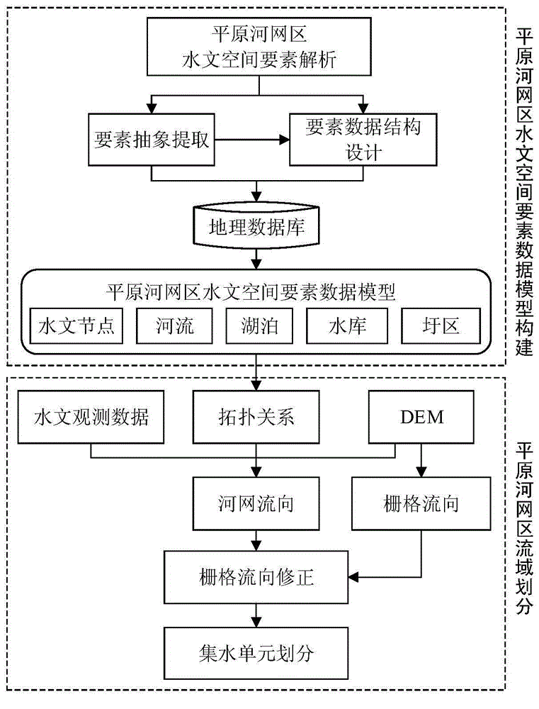
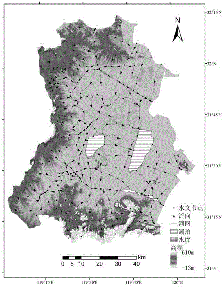
[0030] Combined with the accompanying drawings, the Lake West District (7722km 2 ) as an example, the present invention will be further described in detail.

[0031] (1) Digitize the river and lake network in the west of the lake. The river network, lakes, reservoirs, polders, drainage and irrigation stations, and hydrological stations were extracted respectively through the water system map and thematic map of hydraulic facilities in the west of the lake.

[0032] (2) Extract hydrological nodes. Use the FeatureVerticesToPoints tool of ArcGIS to extract hydrological nodes.

[0033] (3) Define the hydrological node type. Use hydrological data to manually define the types of river basin outlet nodes, lake inlet and outlet nodes, and reservoir inlet and outlet nodes, then automatically identify river source nodes and river channel connection nodes through spatial correlation, and finally supplement irrigation and drainage station nodes and hydrological station nodes.

[0034]...


PUM


Abstract

The invention discloses a digital river-lake network based method for dividing a water collection unit of a river basin of a plain river network region. A traditional method for generating a grid flow direction matrix by a DEM (digital elevation model) to extract a river network is changed, and real digital river-lake networks are directly adopted and used for assisting in division of the water collection unit of the river basin to expectedly obtain a drainage structure really expressing a hydrological topological relation of the plain river network region, and the water collection unit. The method comprises the following steps of: step 1, constructing a hydrological space element data model of the plain river network region; step 2, extracting a hydrological node, defining a vector river network flow direction according to the node type, and establishing a topological relation between the river-lake networks; step 3, generating a grid flow direction by using the DEM, and correcting the grid flow direction by using the river-lake networks with a flow direction relation; and step 4, according to the grid flow direction and the positions of the river-lake networks, dividing the water collection unit of the river basin. The method solves the problem in division of the water collection unit of the plain river network region with a complicated river-lake network structure, and is of great significance on distributed hydrological simulation of the plain river network region.

Description

technical field [0001] The invention relates to a method for dividing watershed water collection units facing plain river network areas, and the technical application field is hydrological analysis and simulation. Background technique [0002] Distributed hydrological models are widely used in the simulation of hydrological processes in river basins, and have become an indispensable tool for scientific understanding and reasonable solutions to water resources and water environment problems. In order to better reflect the spatial variability of geographical elements and geographical processes, distributed hydrological modeling needs to divide the entire watershed into smaller spatial units with relatively single hydrological processes. The reasonable division of spatial units is the basis of distributed hydrological simulation. important basis. [0003] At present, the division of watersheds usually adopts the hydrological analysis method based on the digital elevation model...

Claims


Application Information

Patent Timeline
IPC IPC(8): G06F17/50
Inventor 李硕赖正清
Owner NANJING NORMAL UNIVERSITY
Why Eureka
Try Eureka