Bayesian estimation-based particle filter gravity-assisted inertial navigation matching method

A technology of Bayesian estimation and particle filtering, which is applied in navigation calculation tools, navigation through speed/acceleration measurement, etc., can solve problems such as easy divergence, and achieve the effects of avoiding errors, good real-time performance, and improved matching accuracy

Inactive Publication Date: 2015-12-16
BEIJING INSTITUTE OF TECHNOLOGYGY
View PDF5 Cites 16 Cited by
  • Summary
  • Abstract
  • Description
  • Claims
  • Application Information

AI Technical Summary

Problems solved by technology

[0004] The purpose of the present invention is to overcome the deficiencies in the prior art, and propose a particle filter gravity-assisted inertial navigation matching method based on Bayesian estimation. When solving nonlinear problems, the particle filter avoids the error caused by linearization. Solve the shortcomings of the traditional point matching algorithm Sandia algorithm that is easy to diverge in the matching area where the gravity anomaly changes greatly

Method used


Image

  • Bayesian estimation-based particle filter gravity-assisted inertial navigation matching method
  • Bayesian estimation-based particle filter gravity-assisted inertial navigation matching method
  • Bayesian estimation-based particle filter gravity-assisted inertial navigation matching method

Examples


Embodiment Construction

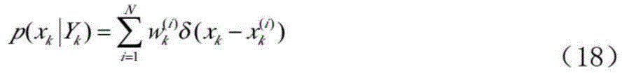
[0019] Step 1: According to the motion law of the underwater vehicle, the longitude and latitude information of the vehicle is used as the state variable, and the gravity anomaly is measured in real time by the gravimeter as the observation value, and the gravity-assisted inertial navigation single-point matching model is established:

[0020] Δx k,k+1 =Δx k-1,k +ΔU k +e k (16)

[0021] the y k = h k (x k )+v k (17)

[0022] In the formula, Δx k,k+1 Indicates the difference in latitude and longitude of the submarine output from time k to k+1, ΔU k Give the inertial navigation system the offset increment at time k, e k INS error, Y k Indicates the gravity anomaly information measured by the gravimeter at time k, h k (x k ) in x k The gravity outlier read on the gravity reference map, v k Indicates gravity anomaly measurement error and gravity reference map error.

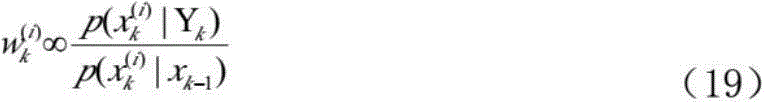
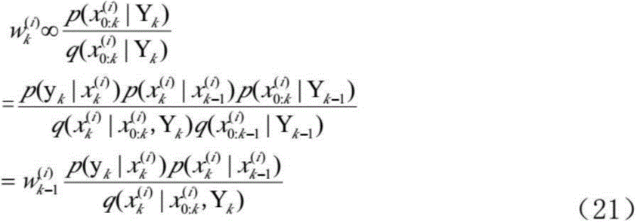
[0023] Step 2: Sequential Importance Sampling

[0024] Bayesian estimation regards state estima...


PUM


Abstract

The invention provides a bayesian estimation-based particle filter gravity-assisted inertial navigation matching method. When solving non-linear problems, particle filter prevents linearization-caused errors and solves the problem that the traditional point matching Sandia algorithm easily produces divergence in a large-gravity anomalous change matching area. Through use of inertial navigation position information as quantity of state, a gravimeter measured value as observed quantity, bayesian estimation-based particle filter, and a random sample average replacing a probability density function conditional mean, inertial navigation system state variable is estimated.

Description

technical field [0001] The invention relates to a gravity-assisted inertial navigation matching method, which belongs to the technical field of gravity-assisted inertial navigation system matching. Background technique [0002] The most commonly used passive navigation method for long-term concealed navigation of underwater vehicles is the inertial navigation system, but inertial navigation errors will accumulate over time. In order to ensure the concealment and autonomy of navigation, passive navigation with geophysical characteristics is used to correct inertial navigation errors. Therefore, researches on terrain matching navigation technology, gravity-assisted navigation technology, and geomagnetic-assisted navigation technology have been carried out. For underwater navigation, the measurement of terrain data is difficult, the earth's magnetic field is not very stable, the gravity field is stable and the gravity data can be retrieved using satellite data, so the applicati...

Claims


Application Information

Patent Timeline
Patent Type & Authority Applications(China)
IPC IPC(8): G01C21/20G01C21/16
CPCG01C21/20G01C21/16
Inventor 王博于力邓志红肖烜
Owner BEIJING INSTITUTE OF TECHNOLOGYGY
Why Eureka
Try Eureka