

Road state identification method based on mobile phone signal
A technology of mobile phone signaling and road status, which can be used in location information-based services, road vehicle traffic control systems, traffic flow detection, etc., and can solve problems such as expensive, easy to damage, and large measurement errors
Inactive Publication Date: 2016-01-13
SOUTH CHINA UNIV OF TECH
View PDF9 Cites 30 Cited by
- Summary
- Abstract
- Description
- Claims
- Application Information
AI Technical Summary
Problems solved by technology
It has the following shortcomings: (1) The collection content is limited and the collection data is incomplete. Generally, the coils are buried at a distance of 1000 meters on expressways, national highways, and provincial highways. Data acquisition is powerless; (2) The investment is very large, and the cost of acquisition is very high. Because the coil is expensive, a large number of laying coils will make the overall investment huge; (3) It is easy to damage and the maintenance cost is high
[0006] (3) In dense urban areas, the measurement error will become larger;
[0007] (4) It is almost impossible to identify the way users travel
Method used
View moreImage
Smart ImageViewing Examples

Examples
Embodiment
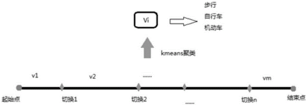
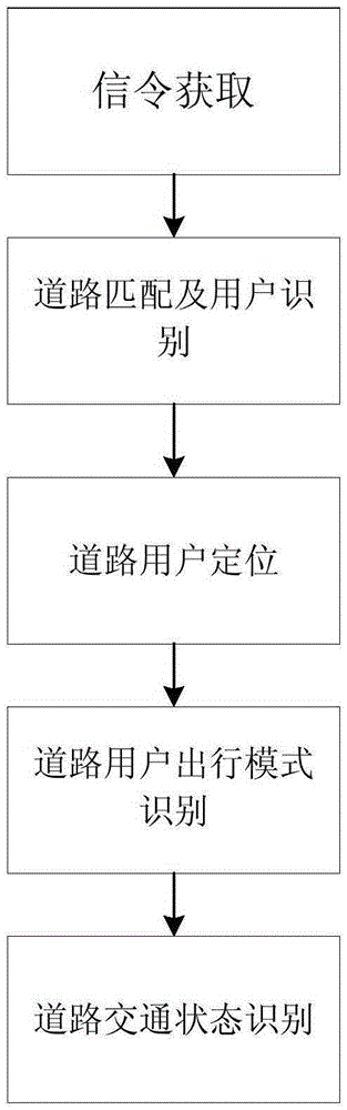
[0042] Such as image 3 Shown, a kind of road state recognition method based on mobile phone signalling, comprises the following steps:
[0043] Step 1. Mobile phone signaling collection. Based on the mobile operator's BSS domain data management system, track mobile phone users in the target city and collect signaling data of mobile phone users within the city. The signaling data mainly includes: IMSI (Unique Identity of Anonymous Encrypted User), CELL_ID (Base Station Cell Number), TIME (Time Stamp), LOCATION (Latitude and Longitude), and EVENT (Event Type).
Login to View More PUM
 Abstract
The invention discloses a road state identification method based on mobile phone signals. The method comprises the following steps: firstly, acquiring mobile phone signals; secondly, matching users with roads, and identifying the users and the roads; thirdly, positioning the users on the roads; fourthly, identifying travel modes of the users on the roads; and fifthly, identifying the traffic state of the roads. The advantages are that the method is convenient to obtain and low in cost, has remarkable popularization values and market development potentials, etc.
Description
technical field [0001] The invention relates to the field of mobile communication technology and GIS technology, in particular to a road state recognition method based on mobile phone signaling. Background technique [0002] With the continuous development of cities and the acceleration of urbanization, the increasing traffic congestion will affect the normal performance of urban functions. In order to alleviate the situation of urban traffic congestion, the construction of intelligent transportation systems is imminent. In the intelligent transportation system, the collection of traffic data is closely related to the identification of traffic status, and is an important part of the system. [0003] At present, the mainstream traffic data acquisition technologies mainly include induction loop detection method and GPS positioning detection method. Among them, the induction coil detection method relies on the electric induction change generated by one or a group of induction ...
Claims
Login to View More Application Information
Patent Timeline
 Patent Type & AuthorityApplications(China)
IPC IPC(8): G08G1/01G08G1/052H04W4/02
Inventor胡斌杰詹益旺李晓欢
OwnerSOUTH CHINA UNIV OF TECH