A Ship Target Detection Method Based on Coastline Data and Spectrum Analysis

A technology of target detection and spectrum analysis, applied in image analysis, image data processing, instruments, etc., can solve the problems of confusion between ship targets and ground objects, inability to effectively remove noise, and high consumption of ship target detection, so as to achieve noise removal. Effect

Active Publication Date: 2017-11-07
HARBIN INST OF TECH
View PDF6 Cites 0 Cited by
  • Summary
  • Abstract
  • Description
  • Claims
  • Application Information

AI Technical Summary

Problems solved by technology

[0005] The purpose of the present invention is to solve the problems in the prior art that the noise cannot be effectively removed and the detection of the ship target in the large-format satellite image consumes large computing resources and time due to the easy confusion of the ship target and the ground object, and the proposed A Ship Target Detection Method Based on Coastline Data and Spectrum Analysis

Method used


Image

  • A Ship Target Detection Method Based on Coastline Data and Spectrum Analysis
  • A Ship Target Detection Method Based on Coastline Data and Spectrum Analysis
  • A Ship Target Detection Method Based on Coastline Data and Spectrum Analysis

Examples


specific Embodiment approach 1

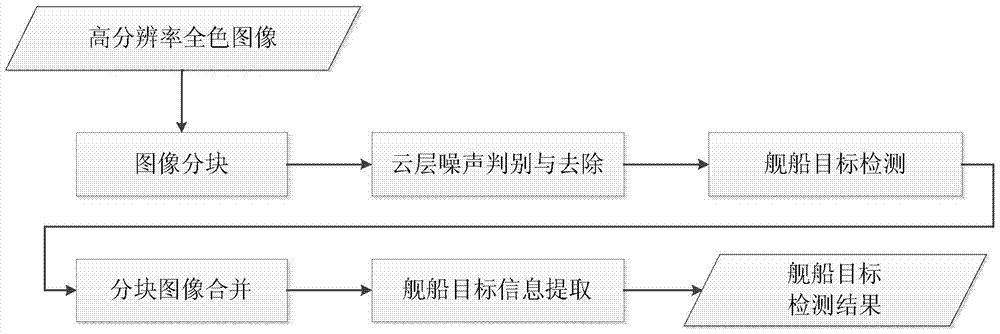
[0046] Specific implementation mode one: a kind of ship target detection method based on coastline data and frequency spectrum analysis of the present implementation mode is specifically prepared according to the following steps:

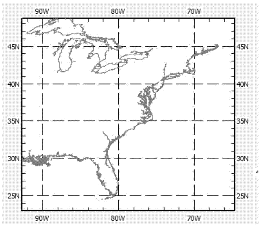
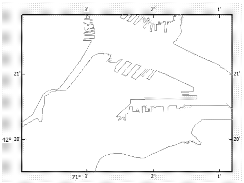
[0047] Step 1. Land noise removal based on coastline data; obtain coastline vector data and high-resolution satellite remote sensing images at the same location, and complete the unification of the two types of data coordinate systems according to the scale of coastline vector data and the resolution of high-resolution satellite remote sensing images ( That is, to complete the determination of the coastline vector data and the origin of the coordinates of the high-resolution satellite remote sensing image), after manually correcting the tiny details, use the land mask to remove the noise of land features in the high-resolution satellite remote sensing image; The image data whose background is all ocean is the image after the mask;

[0048]Step 2, cl...

specific Embodiment approach 2

[0065] Specific embodiment two: the difference between this embodiment and specific embodiment one is: the coastline vector data and high-resolution satellite remote sensing image of the same place are obtained in step one, and the resolution of the coastline vector data scale and high-resolution satellite remote sensing image is completed The unification of the two types of data coordinate systems, after manually correcting tiny details, use land masks to remove land feature noise in high-resolution satellite remote sensing images; the specific process of forming image data with the background of the ocean, that is, the masked image is as follows:

[0066] (1) Data preparation; the metadata carried by a high-resolution remote sensing satellite image records the basic information when the image is acquired; for the land mask method, the image is required to provide the shooting position information, which is generally expressed in latitude and longitude;

[0067] The coastline ...

specific Embodiment approach 3

[0076] Embodiment 3: This embodiment is different from Embodiment 1 or Embodiment 2 in that: the limit range of the scale is 1:10000 to 1:600000. Other steps and parameters are the same as those in Embodiment 1 or Embodiment 2.


PUM


Abstract

A ship target detection method based on coastline data and frequency spectrum analysis, the invention relates to a ship target detection method. The present invention is to solve the problems that the existing technology cannot effectively remove noise and the detection of ship targets in large-format satellite images consumes relatively large computing resources and time, and proposes a ship target detection based on coastline data and spectrum analysis method. The method is to firstly form the image data with the background of the ocean, that is, the image after the mask; secondly, obtain the image after removing the cloud layer noise; thirdly, obtain the binarized image, and detect the seed point or Seed area; grow the ship hull area according to the detected seed point or seed area; 4. Screen through the area and aspect ratio characteristics of the ship hull area to obtain the final high-resolution satellite image ship target detection The results and other steps are achieved. The invention is applied in the field of ship target detection.

Description

technical field [0001] The invention relates to a ship target detection method, in particular to a ship target detection method based on coastline data and frequency spectrum analysis. Background technique [0002] With the development of satellite remote sensing technology, obtaining high-resolution images has become one of the trends. The target details in the high-resolution image are clear and the gray level information is rich, which provides a good data basis for target detection. For the application of high-resolution remote sensing images, target detection is an important application. Ship targets in marine remote sensing images have high economic and military values, and it is meaningful to accurately locate ship targets based on remote sensing images. [0003] The existing detection of ship targets, especially the detection of ship targets in high-resolution images, is often disturbed by more noise. Among them, one kind of noise is the interference introduced by...

Claims


Application Information

Patent Timeline
Patent Type & Authority Patents(China)
IPC IPC(8): G06T5/00G06T7/11G06T7/136
Inventor 张钧萍金天明
Owner HARBIN INST OF TECH
Why Eureka
Try Eureka