Based-on-GIS-analysis system and method for realizing precise project land exploitation addressing

A land and project technology, applied in the field of system based on GIS analysis to realize precise site selection for project land development, can solve problems such as unreasonable traffic accessibility design and infringement

Inactive Publication Date: 2016-03-16
海南图语地理信息技术有限公司
View PDF4 Cites 27 Cited by
  • Summary
  • Abstract
  • Description
  • Claims
  • Application Information

AI Technical Summary

Problems solved by technology

Many investors often only see huge profits, and invest blindly only by analyzing the advantages and disadvantages of the land from a macro perspective, fundamentally ignoring a key link, that is, the scientific location demonstration of the devel...

Method used


Image

  • Based-on-GIS-analysis system and method for realizing precise project land exploitation addressing
  • Based-on-GIS-analysis system and method for realizing precise project land exploitation addressing

Examples


Embodiment Construction

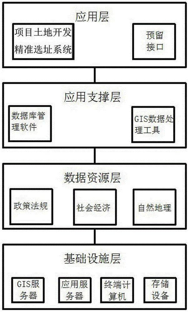
[0052] Combine below figure 1 The present invention will be further described with specific embodiments.

[0053] A system based on GIS analysis to realize precise site selection for project land development, the system includes infrastructure layer, data resource layer, application support layer, and application layer;

[0054]The infrastructure layer provides basic support for the system data resources and software systems, and realizes information circulation and security management between various parts of the system;

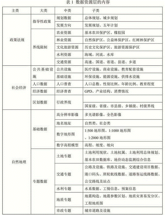
[0055] The data resource layer realizes unified storage and management of spatial data and non-spatial data;

[0056] The application support layer is based on GIS data processing tools to realize the processing and database building of spatial data and thematic data required by the project;

[0057] The application layer is a precise site selection system for project land development based on data resources.

[0058] The infrastructure layer includes GI...


PUM


Abstract

The invention discloses a based-on-GIS-analysis system and a method for realizing precise project land exploitation addressing. The system comprises an infrastructure level, a data resource level, an application supporting level and an application level, wherein the infrastructure level provides basic support for system data resources and a software system and realizes information circulation among various system parts and safety management, the data resource level realizes unified storage and management on space data and non-space data, the application supporting level is based on GIS data processing tools and realizes processing and database establishment for space data and thematic data required by projects, and the application level is a precise project land exploitation addressing system established on the basis of the data resources. According to the system, the GIS technology is utilized, in combination with land demands of investment developers, position-based comprehensive quantitative analysis on policies and regulations, social economy and physical geography is carried out, early-stage land exploitation cost is reduced for the investment developers, program sorting and time control are realized, and thereby scientific decision is provided for project landing feasibility.

Description

technical field [0001] The utility model relates to the field of land use and site selection systems, in particular to a system and method for realizing precise site selection for project land development based on GIS analysis. Background technique [0002] Land is the basis for human survival and various economic and social activities. With the rapid development of industrialization and urbanization, land development and utilization activities are constantly increasing. Many investors often only see huge profits, and invest blindly only by analyzing the advantages and disadvantages of the land from a macro perspective, fundamentally ignoring a key link, that is, the scientific location demonstration of the development project, which leads to many problems for land investment and development. problems, such as violations of red lines such as basic farmland, coastlines, and cultural relics protection areas, and unreasonable design of traffic accessibility. [0003] With the ...

Claims


Application Information

Patent Timeline
IPC IPC(8): G06Q50/16G06F17/30
CPCG06Q50/165G06F16/29
Inventor 谭建姚叶萍周俊李会元李文水毛燕阳王雪娣
Owner 海南图语地理信息技术有限公司
Why Eureka
Try Eureka