Cloud radar and satellite detection data fusion method and cloud radar and satellite detection data fusion system

A technology of satellite detection and data fusion, applied in the field of meteorological detection, can solve the problem that the description of cloud level distribution is not as good as that of satellites

Active Publication Date: 2016-03-30
CMA METEOROLOGICAL OBSERVATION CENT
View PDF3 Cites 15 Cited by
  • Summary
  • Abstract
  • Description
  • Claims
  • Application Information

AI Technical Summary

Problems solved by technology

However, the deployment density of the ground-based millimeter-wave nephelometer determines that the description o

Method used


Image

  • Cloud radar and satellite detection data fusion method and cloud radar and satellite detection data fusion system
  • Cloud radar and satellite detection data fusion method and cloud radar and satellite detection data fusion system
  • Cloud radar and satellite detection data fusion method and cloud radar and satellite detection data fusion system

Examples


Embodiment Construction

[0021] Below, the substantive features and advantages of the present invention will be further described in conjunction with examples, but the present invention is not limited to the listed examples.

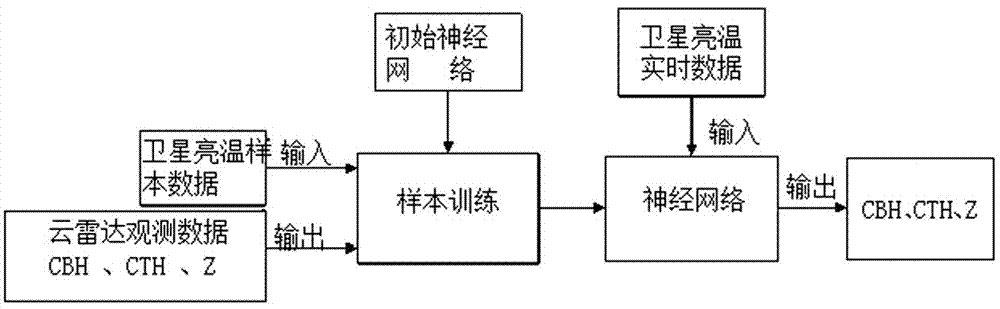
[0022] see figure 1 As shown, a cloud radar and satellite detection data fusion method includes the following steps:

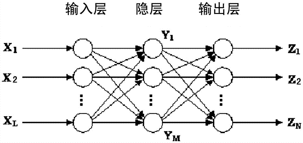
[0023] Establish the neural network of brightness temperature detected by satellite and cloud top height CTH, cloud base height CBH and average reflectivity factor Z detected by millimeter-wave cloud radar;

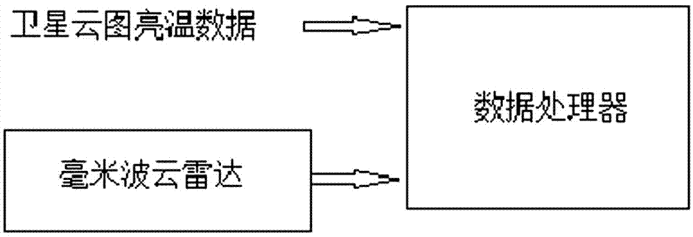
[0024] Obtain the satellite brightness temperature data corresponding to the sky above the millimeter-wave cloud radar and input it into the neural network, and process the real-time satellite brightness temperature data and the cloud top height CTH, cloud base height CBH and average reflectance factor detected by the millimeter-wave cloud radar through the neural network Z data, output the cloud top height CTH, cloud base height CBH, and average reflectiv...


PUM


Abstract

The invention relates to a cloud radar and satellite detection data fusion method and a cloud radar and satellite detection data fusion system. The cloud radar and satellite detection data fusion method is characterized in that cloud top heights, cloud bottom heights, and average reflectivity factors detected by a millimeter-wave cloud radar can be achieved, and the satellite cloud picture brightness temperature data corresponding to the overhead part of the millimeter-wave cloud radar can be achieved; the cloud top heights, the cloud bottom heights, and the average reflectivity factors corresponding to the brightness temperature values of the area covered by the satellite cloud picture can be output in a real-time manner by the processing of the trained neural network of the satellite brightness temperatures, and the cloud top heights, the cloud bottom heights, and the average reflectivity factors detected by the millimeter-wave cloud radar. The horizontal distribution chart of the cloud top heights, the cloud bottom heights, and the average reflectivity factors of the area covered by the satellite cloud picture can be achieved, and then the new cloud information can be provided for the weather forecast analysis, the mathematical forecast, and the atmosphere scientific research.

Description

technical field [0001] The invention belongs to the technical field of meteorological detection, and in particular relates to a cloud radar and satellite detection data fusion method and system. Background technique [0002] Cloud distribution, cloud amount, and cloud shape can be obtained from meteorological satellite cloud images, but the vertical structure distribution of clouds is not given. The cloud top height information can be retrieved from the infrared cloud image. Since the cloud top height information is retrieved using the correlation between infrared radiation and temperature, and the infrared radiation intensity is also related to factors such as cloud structure (density), the error in inversion of cloud top height is relatively large. . In terms of information integrity, meteorological satellite cloud images cannot meet meteorological needs for cloud height information, especially numerical forecasting is very sensitive to cloud height, which directly affect...

Claims


Application Information

Patent Timeline
IPC IPC(8): G01W1/00G06N3/02G06N3/08
CPCG01W1/00G06N3/02G06N3/08Y02A90/10
Inventor 马舒庆唐英杰陶法胡树贞刘聪
Owner CMA METEOROLOGICAL OBSERVATION CENT
Why Eureka
Try Eureka