A method for accurately finding underground facilities using underground electronic markers

An electronic marker and underground facility technology, which is applied in the field of detection and search of underground pipelines, can solve the problems of no damage to the pipeline system, inappropriate search methods, and failure to dig damaged pipelines, etc., so as to reduce manpower and achieve high search efficiency. , Find the effect of accurate positioning

Active Publication Date: 2018-10-23
BEIJING RXG TECH
View PDF14 Cites 0 Cited by
  • Summary
  • Abstract
  • Description
  • Claims
  • Application Information

AI Technical Summary

Problems solved by technology

Although those skilled in the art know that it is necessary to locate underground pipelines by searching for underground electronic markers, the reality is that it often takes a long time to find damaged pipelines due to inappropriate search methods, but during this process, the staff have dug wrongly Many normal working pipelines have caused some damage to the undamaged pipeline system, and there are also some cases where the damaged pipeline cannot be dug at all

Method used


Image

  • A method for accurately finding underground facilities using underground electronic markers
  • A method for accurately finding underground facilities using underground electronic markers
  • A method for accurately finding underground facilities using underground electronic markers

Examples


Embodiment 1

[0028] The present invention requires the aid of a comprehensive management system for pipelines, a mobile device, and a detector. Underground electronic markers are buried near the underground facilities. The underground electronic markers record the attribute information, location information and ground reference maps of the underground facilities. As long as you find the underground electronic markers, you can find the corresponding underground equipment, such as underground pipelines. .

[0029] It should be noted that the underground electronic marker of the present invention refers to an information product developed based on Internet of Things technology.

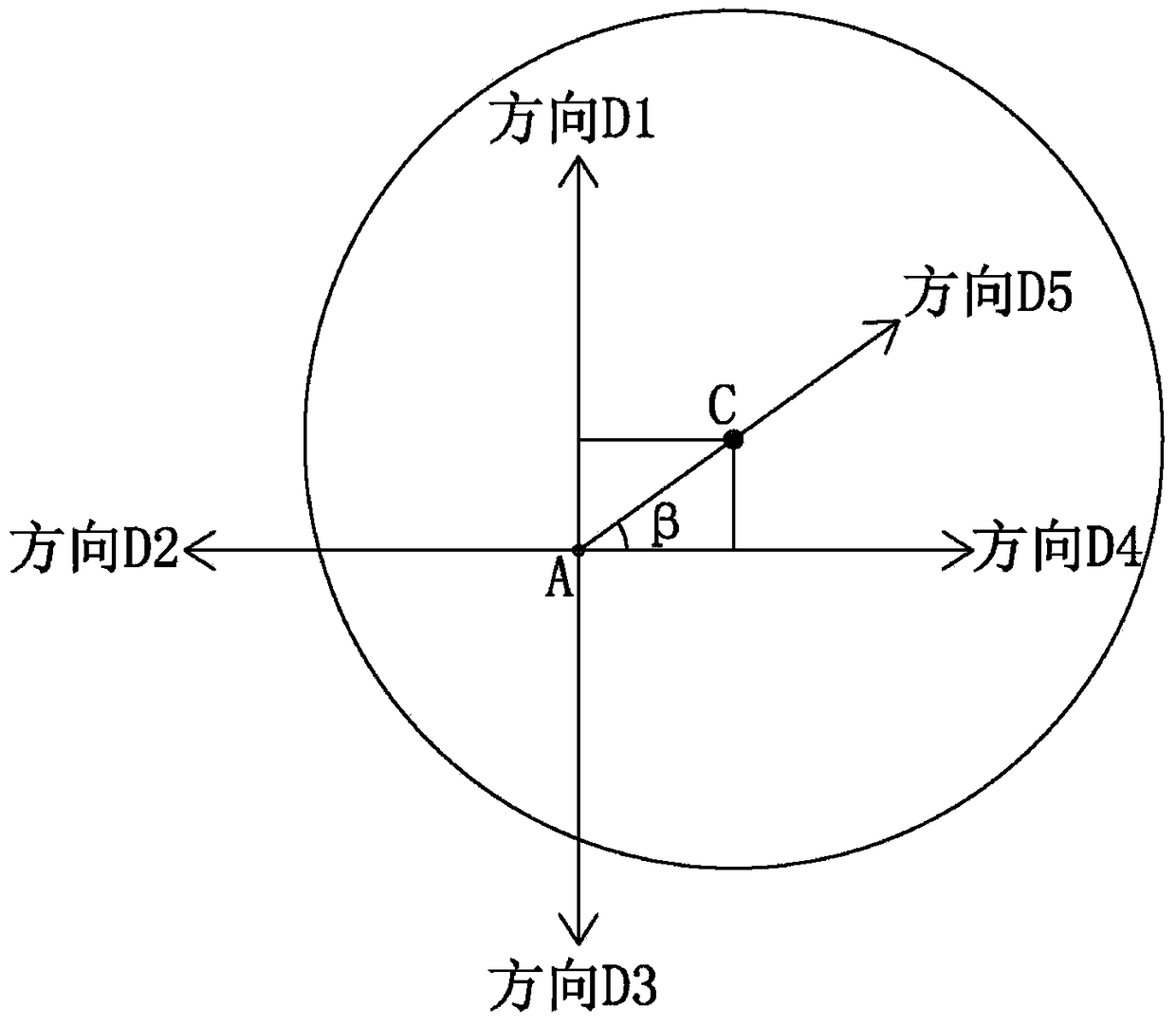
[0030] Such as figure 1 As shown, the present invention uses the satellite navigation system to determine the theoretical position coordinate point A of the underground electronic marker, and the coordinate point A is within the electromagnetic field range of the underground electronic marker to be detected. Specif...

Embodiment 2

[0040] Such as figure 2 , 3 As shown, the method of using the underground electronic marker to accurately search for underground facilities in the second embodiment is basically the same as that in the first embodiment, except that the selection method of the direction D5 is different.

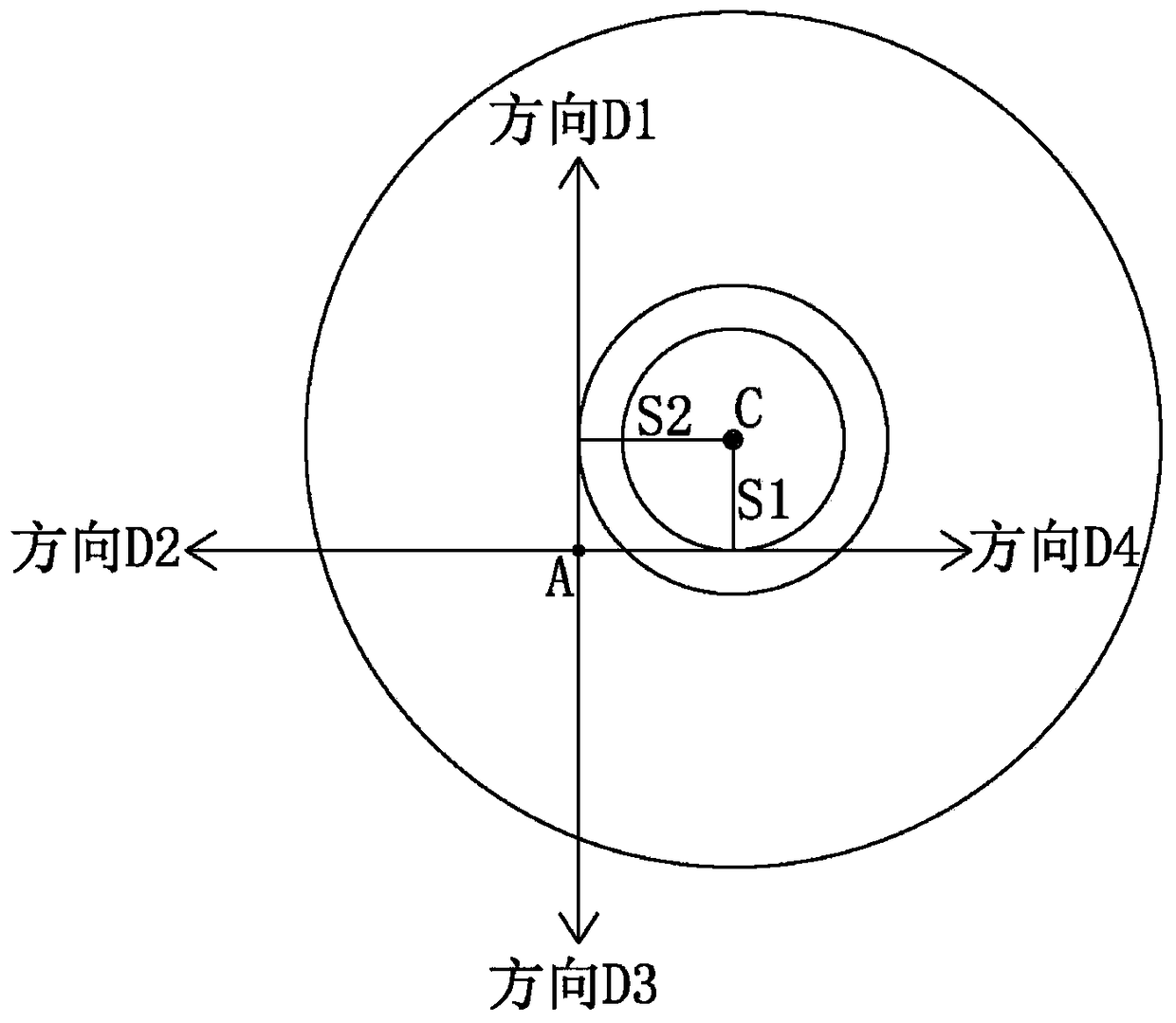
[0041] In step S1 of this embodiment, the distance between the point with the highest magnetic field strength in the D1 direction and A is S1, and the distance between the point with the highest magnetic field strength in the D2 direction and A is S2; then in the S2 step, the search angle β is arctan(S1 / S2) or arctan(S2 / S1). Of course, those skilled in the art can judge whether the value of angle β is arctan (S1 / S2) or arctan (S2 / S1) according to the magnitude of the magnetic field strength trend of D1 and D4, for example, if the magnetic field strength trend along direction D4 is greater than that along direction D1 The magnetic field strength trend, the value of the angle β is arctan(S1 / S...

Embodiment 3

[0044] Such as Figure 4 As shown, when the four directions are not necessarily vertical, the present invention can also find underground electronic markers for underground pipelines in the following manner.

[0045] Using the satellite navigation system to judge the theoretical geographic location coordinate point A of the underground electronic marker; it is characterized in that: it also includes the following steps,

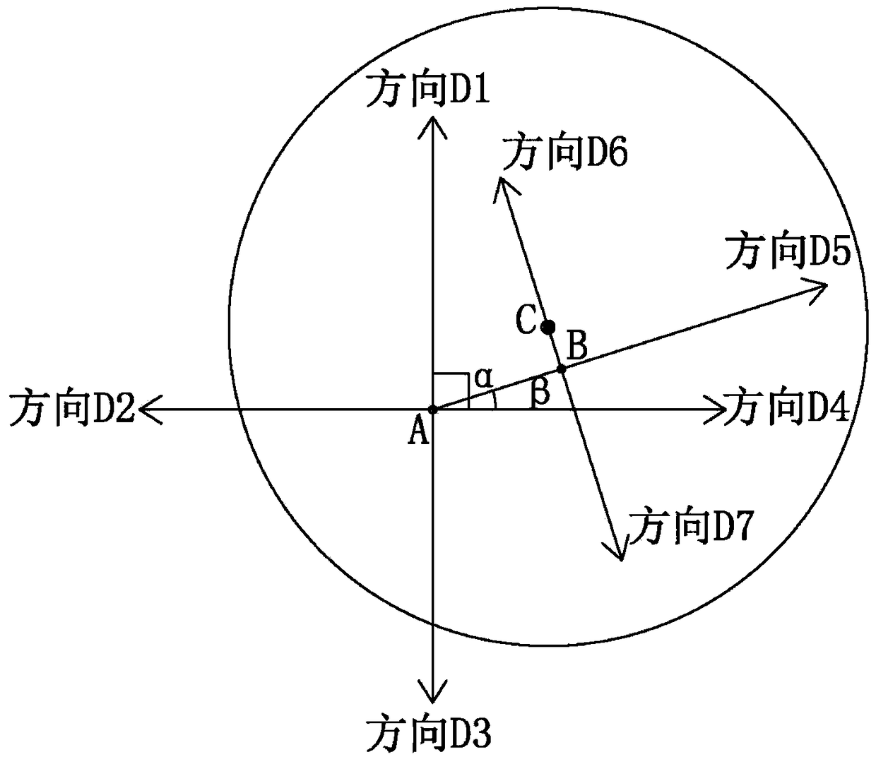
[0046] S1: Taking A as the starting point, use the detector to search in four directions D1, D2, D3, and D4 respectively, and determine the two adjacent directions D1 and D4 with the largest electromagnetic field strength of the underground electronic marker. In the area of ​​angle α between two directions, the angle α is less than 180°;

[0047] S2: Determine the two points A1 and A2 with the largest electromagnetic field strength in the directions D1 and D4 respectively, and in the area of ​​the included angle α, start from A1 and A2 respectively and searc...


PUM


Abstract

The invention relates to a method for searching an underground facility by using an underground electronic identifier precisely. A navigation system is used for determining a coordinate point A of a theoretical geographic position of an underground electronic identifier; a detector carries out searching at multiple directions by using the A as a starting point and two adjacent directions with the highest electromagnetic field intensities of the underground electronic identifier are determined; searching is carried out at one direction in an included angle area of the two directions by using the A as a starting point again, and a coordinate point B with the highest electromagnetic field intensity is determined at the direction; and searching is carried out along two directions perpendicular to the direction by using the B point as a starting point, and the electromagnetic field intensity must be gradually increased at one direction, so that the position with the highest electromagnetic field intensity is a burying point of the underground electronic identifier. According to the invention, the method has characteristics of accurate searching and positioning and high searching efficiency and the like; a target underground electronic identifier can be searched timely and accurately and thus a needed underground pipe can be searched, so that the manpower and materials for searching corresponding pipes can be substantially reduced.

Description

technical field [0001] The invention relates to the technical field of detection and searching of underground pipelines, more specifically, a method for accurately searching underground facilities by using an underground electronic marker. Background technique [0002] The number of urban pipelines is increasing. As time goes by, some pipelines may be damaged due to man-made or natural reasons. At this time, the damaged pipelines need to be repaired. However, due to the time course or other reasons, the equipment buried underground has the characteristics of "invisibility" and cannot be repaired. It is difficult to accurately find the specific location of the damaged pipeline. Even if there are records of buried pipelines, due to crustal movement And other factors, the actual geographical location of the pipeline will also change. Therefore, the geographical location of the pipeline needs to be re-determined. [0003] For the determination of the actual geographical locati...

Claims


Application Information

Patent Timeline
Patent Type & Authority Patents(China)
IPC IPC(8): G01V3/08
CPCG01V3/081
Inventor 黄建华
Owner BEIJING RXG TECH
Why Eureka
Try Eureka