Remote sensing image data processing system and method thereof

A data processing system, remote sensing image technology, applied in image communication, digital video signal modification, electrical components, etc., can solve problems such as inability to meet, and achieve the effect of reducing storage capacity requirements and reducing costs

Inactive Publication Date: 2016-04-06
TIANJIN HANMING TECH DEV CO LTD
View PDF0 Cites 3 Cited by
  • Summary
  • Abstract
  • Description
  • Claims
  • Application Information

AI Technical Summary

Problems solved by technology

However, the traditional remote sensing image data processing system can only process one remote sensing satellite image signal on the same side, which cannot meet the requirements of the remote sensing image data processing system that needs to receive multiple signals.

Method used


Image

  • Remote sensing image data processing system and method thereof

Examples


Embodiment Construction

[0010] The present invention will be further described below in conjunction with drawings and embodiments.

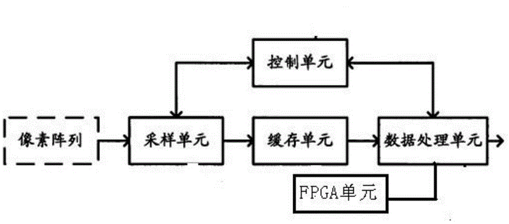
[0011] Such as figure 1 As shown, the present invention provides a remote sensing image data processing system and method thereof, including a sampling unit, a cache unit, a data processing unit, an FPGA unit, and a control unit, and a sampling unit for obtaining image information in a line scanning sampling manner, and The image information is provided to the cache unit; the cache unit is used to cache the image information provided by the sampling unit in units of rows; the data processing unit is used to compress the image information cached in the cache unit and output the compressed image information; The control unit is used to judge whether the predetermined condition is satisfied, and after the predetermined condition is satisfied, send an instruction to the sampling unit to suspend the acquisition of the image information, and send an instruction to the data pr...


PUM


Abstract

The invention provides a remote sensing image data processing system and a method thereof. The system comprises a sampling unit, a buffering unit, a data processing unit, an FPGA unit and a control unit, and is characterized in that the sampling unit is used for acquiring image information in a line scanning sampling mode, and the image information is provided for the buffering unit; the buffering unit is used for buffering the image information provided by the sampling unit with the line as a unit; and the data processing unit is used for compressing the image information buffered in the buffering unit and outputting the image information completing compression. The system and the method of the invention have the beneficial effects that the image information acquired through sampling only needs to be buffered before compression processing, no new image information needs to be buffered when compression processing is carried out, the requirement on the storage capacity of the buffering module is greatly reduced, and the image data processing cost is effectively reduced.

Description

technical field [0001] The invention belongs to the technical field of remote sensing image demodulation and processing, and in particular relates to a remote sensing image data processing system and a method thereof. Background technique [0002] Remote sensing technology integrates the latest technological achievements in space, electronics, optics, computer communication and geosciences, and obtains a large amount of precious image data for human beings to study the earth. Low-orbit high-definition remote sensing images play an important role in national ecological environment control, water resource management, mineral resource management, forest resource management, land resource management, military struggle, national defense security and various scientific researches. The development of many scientific fields is increasingly dependent on the progress of remote sensing technology and the ability to obtain remote sensing data. [0003] High-orbit low-speed remote sensi...

Claims


Application Information

Patent Timeline
Patent Type & Authority Applications(China)
IPC IPC(8): H04N19/426
Inventor 邹燕华
Owner TIANJIN HANMING TECH DEV CO LTD
Why Eureka
Try Eureka