
GIS intelligent display system and method of street lamp resource equipment on mobile terminal

A mobile terminal and display system technology, applied in still image data retrieval, special data processing applications, instruments, etc., can solve the problems of high display density of street light facilities, inability to distinguish street light facilities, affecting viewing effects, etc., to achieve good display effects, Effects that improve loading and display speed

Active Publication Date: 2016-04-20
TAIHUA WISDOM IND GRP CO LTD
View PDF4 Cites 6 Cited by
  • Summary
  • Abstract
  • Description
  • Claims
  • Application Information

AI Technical Summary

Problems solved by technology

[0006] When using GIS to display street light facility information on mobile terminals, due to the influence of mobile terminal screen size, street light facility density, and map scale size, the information display is not well handled in terms of details and appropriateness.
[0007] Traditionally, when the map scale of the mobile terminal is large, the visible range of the map on the mobile terminal is small and the geographical information is detailed. The display method of street light equipment information is as simple as that displayed when the map scale is small, but it should be displayed in more detail at this time. information on street lighting facilities; when the map scale is small, the visible range of the map on the mobile terminal is large, the geographical information is simple, and there are a large number of street lighting facilities within the visible range. , the display density of street lighting facilities within the visible range of the map of the mobile terminal is too high, causing the icons to cover or block each other, making it impossible to distinguish street lighting facilities, affecting the viewing effect
[0008] 3. All types of grid icons are loaded in advance on the mobile terminal, which will take up a lot of space, resulting in bloated and huge street light facility resource management system programs

Method used


Image

  • GIS intelligent display system and method of street lamp resource equipment on mobile terminal

Examples


Embodiment Construction

[0038] The present invention will be further described below in conjunction with the accompanying drawings and embodiments.

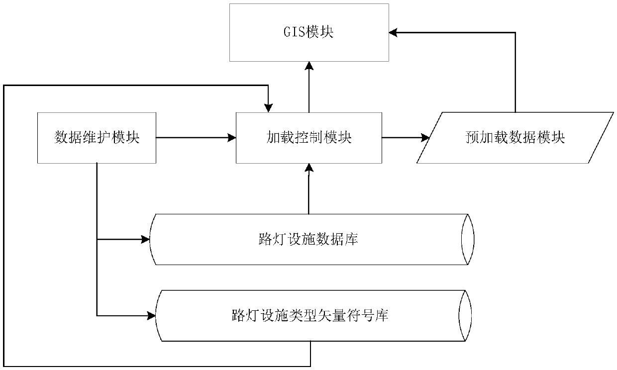
[0039] Such as figure 1 As shown, the GIS module of the mobile terminal: the GIS module of the street lamp management system on the mobile terminal, through which the resource information of the street lamp facility is displayed on the mobile terminal.

[0040] Data maintenance module: realize the unified management of street lamp resource facility information, street lamp resource type vector symbol information, provide a unified external interface, realize functions such as adding, deleting, modifying, querying street lamp facility resource information, street lamp resource type vector symbol information, etc.

[0041] Loading control module: pre-load street light facility data and street light facility type vector symbol data from the street light facility database and street light facility type vector symbol database into the preloaded data cache; ...


PUM


Abstract

The invention discloses a GIS intelligent display system and method of street lamp resource equipment on a mobile terminal. A large number of street lamp facility information can be displayed in real time as needed in the mobile terminal by the use of the GIS intelligent display system and method. Quick loading and display can be achieved via a vector symbol database according to a mobile terminal street lamp facility managing system; direct and reasonably detailed display can be realized via GIS; in the mobile terminal, street lamp facility information display and GIS are combined, so geographic position of the street lamp facilities in reality world can be displayed into icons on a corresponding position of a mobile terminal map; detailed and brief icons of various types of street lamp equipment can be displayed according to a visual range of the mobile terminal screen map and a measuring scale of the visual map in real time; and street lamp facility information can be directly, clearly and reasonably detailedly displayed in real time.

Description

technical field [0001] The invention relates to a GIS intelligent display system and method for street lamp resource equipment on a mobile terminal. Background technique [0002] At present, most street lamp facility resource management systems run on non-mobile terminals, but with the increasing popularity and application of mobile terminals, the application requirements of street lamp facility resource management systems on mobile terminals are becoming increasingly urgent. Due to the characteristics of the mobile terminal itself such as portability, ease of use, small screen, small storage space, and slow operation speed, it is determined that the existing street lighting facility resource management system still has the following defects when applied to the mobile terminal: [0003] 1. The data volume of street lighting facilities is large, and all loading results in slow display [0004] At present, the total number of street lighting equipment in general-scale cities ...

Claims


Application Information

Patent Timeline
Patent Type & Authority Applications(China)
IPC IPC(8): G06F17/30
CPCG06F16/29G06F16/56
Inventor 蒋德民刘思彬徐文鹏杜伟马述杰白生龙庄绪良郝敬全张超曹坤修择
Owner TAIHUA WISDOM IND GRP CO LTD
Learn More