AR navigation method and device, vehicle device, server and medium

A navigation method and equipment technology, applied in the field of Internet of Vehicles, can solve the problem that lane lines cannot be recognized and displayed normally, and achieve the effect of improving accuracy and real-time performance.

Active Publication Date: 2019-06-25
APOLLO INTELLIGENT CONNECTIVITY (BEIJING) TECH CO LTD
View PDF16 Cites 15 Cited by
  • Summary
  • Abstract
  • Description
  • Claims
  • Application Information

AI Technical Summary

Problems solved by technology

[0004] Embodiments of the present invention provide an AR navigation method, device, vehicle-end equipment, server and media to solve the problem that lane lines cannot be normally recognized and displayed in a scene with limited vision

Method used


Image

  • AR navigation method and device, vehicle device, server and medium
  • AR navigation method and device, vehicle device, server and medium
  • AR navigation method and device, vehicle device, server and medium

Examples


Embodiment 1

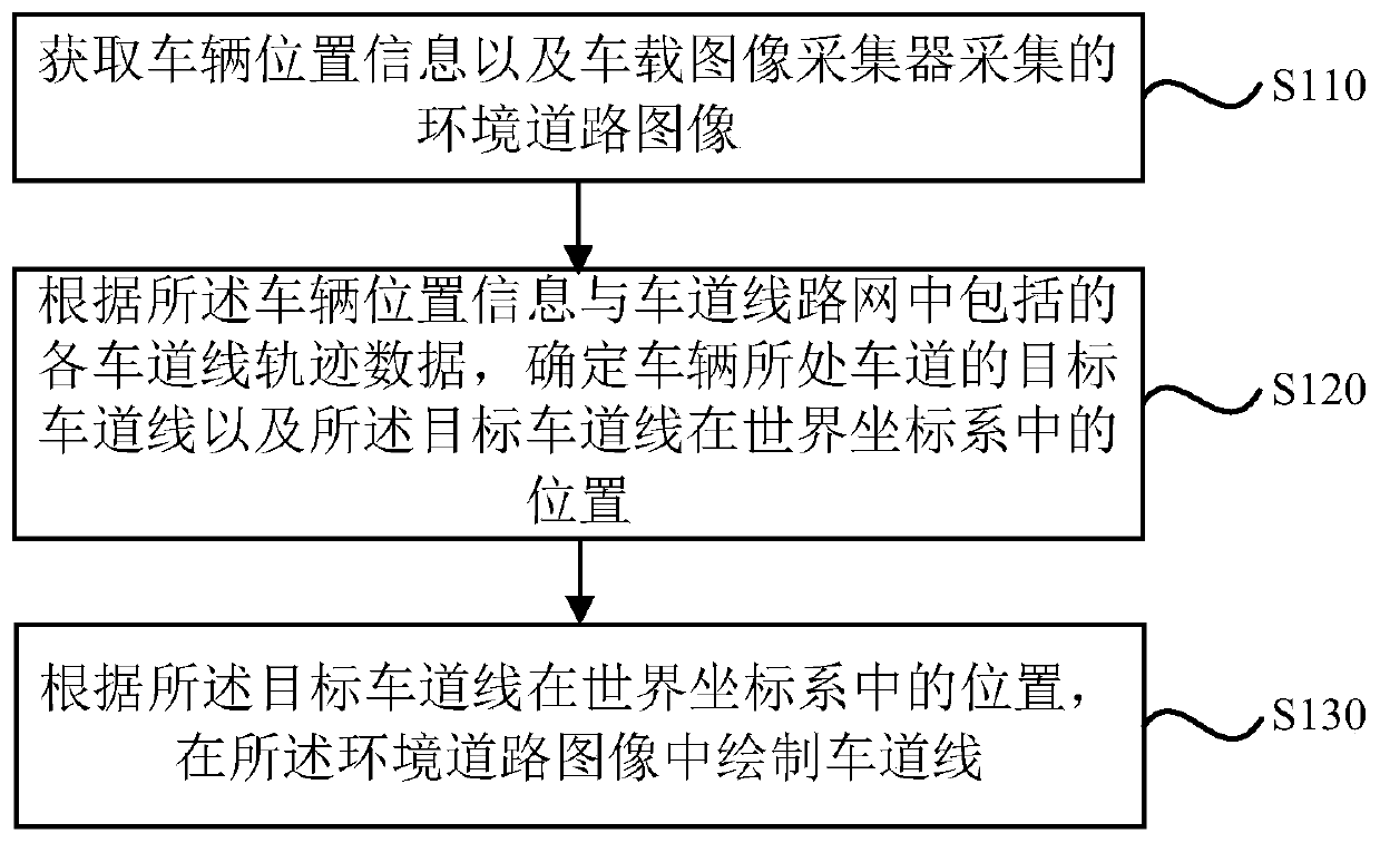
[0039] figure 1 It is a flowchart of an AR navigation method in Embodiment 1 of the present invention. The AR navigation method provided in this embodiment is executed by the vehicle-end device, and is applicable to the situation where the vehicle uses the vehicle-end device for navigation during driving. The method can be performed by an AR navigation device, and the device can be implemented by software and / or hardware. This device can be integrated in the vehicle-end equipment. see figure 1 , the implementation method specifically includes:

[0040] S110. Acquire vehicle location information and environmental road images collected by the vehicle-mounted image collector.

[0041] Specifically, the vehicle is provided with a GPS (Global Positioning System, Global Positioning System), and the location information of the vehicle can be obtained in real time through the GPS. In addition, the vehicle is provided with at least one image collector, which can be installed above ...

Embodiment 2

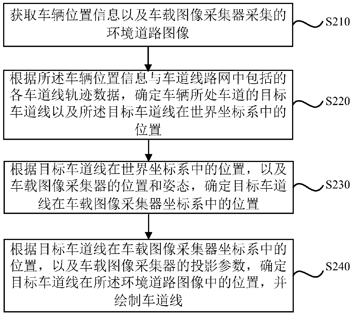
[0049] image 3 It is a flowchart of an AR navigation method in Embodiment 2 of the present invention. This embodiment is optimized on the basis of the above-mentioned embodiments, and details that are not described in this embodiment can be found in the above-mentioned embodiments. see image 3 , the AR navigation method provided in this embodiment includes:

[0050] S210. Acquire the vehicle location information and the environmental road image collected by the vehicle image collector.

[0051] S220. Determine the target lane line of the lane where the vehicle is located and the position of the target lane line in the world coordinate system according to the vehicle position information and the track data of each lane line included in the lane line network.

[0052] Optionally, the lane network is constructed in the following manner: during the vehicle navigation process, according to the vehicle's speed, acceleration, angular velocity, the vehicle's calibrated position i...

Embodiment 3

[0064] Figure 4 It is a flowchart of an AR navigation method in Embodiment 3 of the present invention. The AR navigation method provided in this embodiment is executed by the server, and is applicable to the situation where the vehicle performs AR navigation according to the lane network of the server during driving. The method can be executed by an AR navigation device, which can be implemented by software and / or or hardware, and the device can be integrated in the server. see Figure 4 For details not described in detail in this embodiment, please refer to the above-mentioned embodiment. The method of this implementation specifically includes:

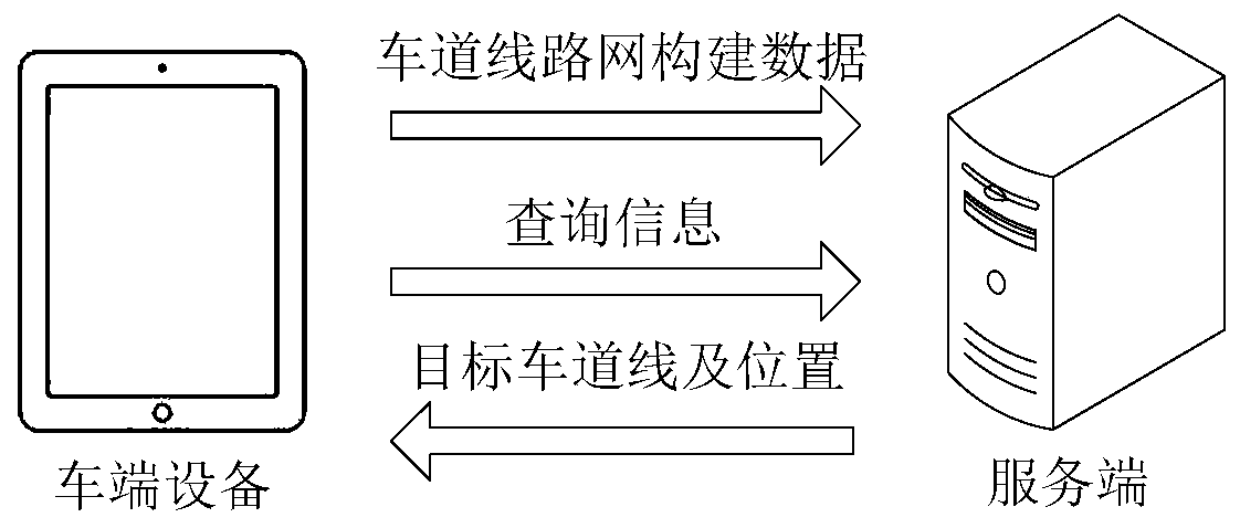
[0065] S310. Obtain the location information of the target vehicle sent by the vehicle-end device.

[0066] Specifically, the server receives the location information of the target vehicle sent by the vehicle-end device.

[0067] S320. Match the position information of the target vehicle with the trajectory data of each lane lin...


PUM


Abstract

The embodiment of the invention discloses an AR navigation method and device, a vehicle device, a server and a medium. The method is executed by the vehicle device. The method comprises the steps of:obtaining vehicle position information; and environment road images collected by a vehicle image collector; according to the vehicle position information and each lane line track data included in a lane line network, determining a target lane line of a lane where the vehicle is located and the position of a target lane line in a world coordinate system; and according to the position of the targetlane line in the world coordinate system, drawing the lane line in the environment road images. According to the vehicle position information and each lane line track data, the target lane line and the position are accurately determined, the target lane line and the position are obtained from the lane line network to achieve timely and accurately obtain the lane line of the current lane in a condition that the lane line cannot be detected in real time, and the lane line is drawn in the environment road images for real-time display so as to improve the accuracy and the timeliness of the AR navigation.

Description

technical field [0001] Embodiments of the present invention relate to the technical field of Internet of Vehicles, and in particular, to an AR navigation method, device, vehicle-end equipment, server and media. Background technique [0002] Currently, users use navigation technology to provide driving guidance while driving a vehicle. Users can know their exact location and road conditions ahead through navigation technology. Among them, lane line recognition is one of the important positioning means in navigation technology. Through lane line recognition, the guide line can be fitted to the current road surface, and the lane condition of the current road surface can be accurately restored. [0003] Lane line detection generally obtains the road image through the image acquisition device during the driving process of the vehicle, and obtains the lane line of the current road through the road image detection. However, in scenes with limited vision, such as nighttime, backli...

Claims


Application Information

Patent Timeline
Patent Type & Authority Applications(China)
IPC IPC(8): G01C21/34G01C21/36G01C21/28
Inventor 李冰周志鹏张丙林李映辉
Owner APOLLO INTELLIGENT CONNECTIVITY (BEIJING) TECH CO LTD
Why Eureka
Try Eureka