Vehicle navigation method and apparatus, electronic map display method and apparatus thereof

A vehicle navigation and electronic map technology, applied in the field of geographic information systems, can solve the problems of inability to quickly find a parking place and inconvenience for drivers to park.

Active Publication Date: 2016-04-27
ALIBABA (CHINA) CO LTD
View PDF4 Cites 23 Cited by
  • Summary
  • Abstract
  • Description
  • Claims
  • Application Information

AI Technical Summary

Problems solved by technology

[0005] Embodiments of the present invention provide a vehicle navigation method and device, and an electronic map display method and device to solve the problem that drivers cannot know in advance whether parking is prohibited on the road section where the destination is located in the prior art, which causes the driver to drive to the destination. It is impossible to find the parking place quickly when it is informed that parking is prohibited on the road section, which causes inconvenience to the driver.

Method used


Image

  • Vehicle navigation method and apparatus, electronic map display method and apparatus thereof
  • Vehicle navigation method and apparatus, electronic map display method and apparatus thereof
  • Vehicle navigation method and apparatus, electronic map display method and apparatus thereof

Examples


Embodiment 1

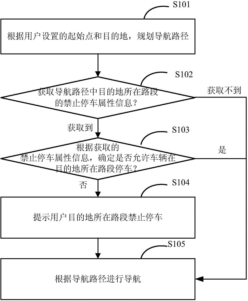
[0045] figure 1 It is a flow chart of the vehicle navigation method provided by Embodiment 1 of the present invention. Such as figure 1 As shown, the method includes:

[0046] S101: Planning a navigation path according to the starting point and destination set by the user;

[0047] S102: From the pre-stored prohibited parking attribute information of the road section, obtain the prohibited parking attribute information of the road section where the destination is located in the navigation route, if it can be obtained, execute step S103, if not, execute step S105;

[0048] S103: Determine whether the vehicle is allowed to park on the road section of the destination according to the prohibited parking attribute information of the road section where the destination is located; if it is determined that parking is not allowed, then execute step S104; if it is determined that parking is allowed, then execute step S105;

[0049] S104: Prompt the user that parking is prohibited on ...

Embodiment 2

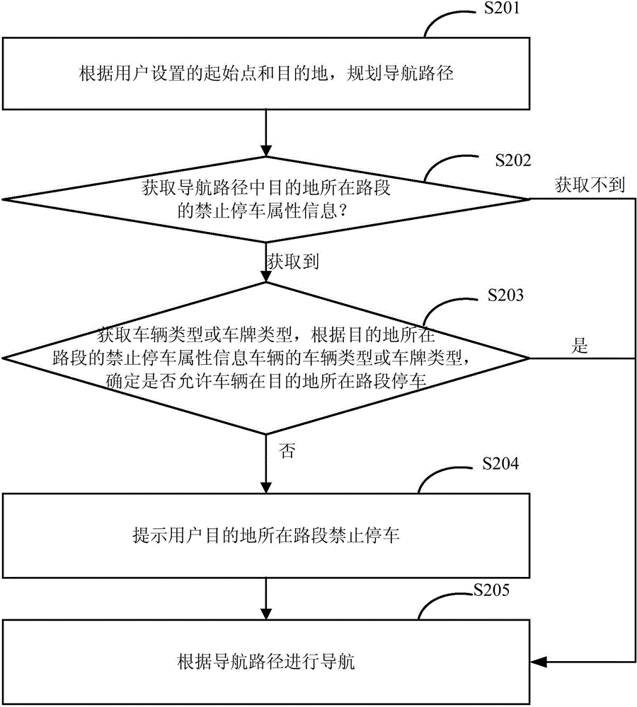
[0069] Embodiment 2 provides a vehicle navigation method, such as figure 2 As shown, the method includes the following steps:

[0070] S201: Planning a navigation path according to the starting point and destination set by the user;

[0071] S202: Obtain the prohibited parking attribute information of the road segment where the destination is located in the navigation route from the pre-stored prohibited parking attribute information; if it can be obtained, execute step S203; if not, execute step 205.

[0072] S203: Obtain the vehicle type or license plate type of the vehicle, and determine whether to allow the vehicle to park on the road segment where the destination is located according to the prohibited parking attribute information of the road segment where the destination is located, and the vehicle type or license plate type of the vehicle; if it is determined that parking is not allowed, execute Step S204; if it is determined that parking is allowed, execute step S205...

Embodiment 3

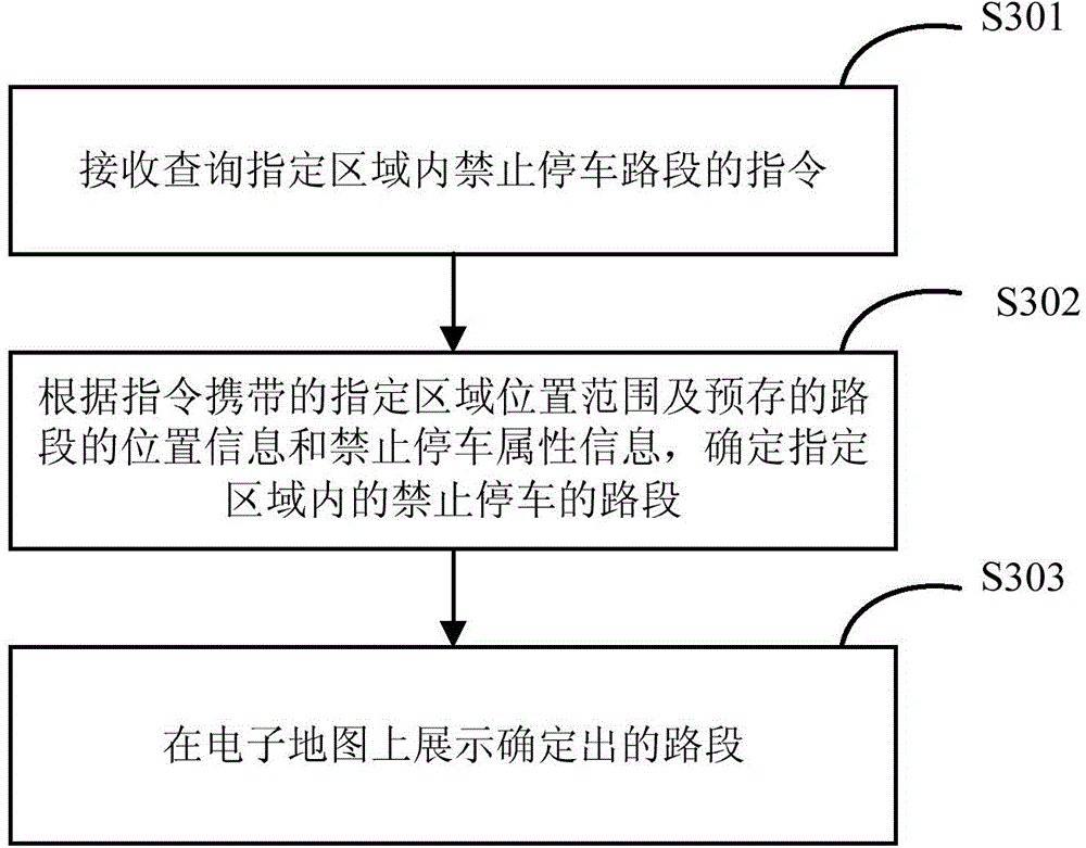
[0100] image 3 It is a flow chart of the electronic map display method provided by Embodiment 3 of the present invention. Such as image 3 As shown, the method includes:

[0101] S301: Receive an instruction to inquire about a road section where parking is prohibited in a designated area;

[0102] S302: Determine the road section where parking is prohibited in the designated area according to the location range of the designated area carried by the instruction, the location information of the pre-stored road section, and the attribute information of the parking prohibition;

[0103] S303: Display the determined road section on the electronic map.

[0104]Wherein, in step S301, the scope of the specified area inquired may be a city, or an administrative district in the city, or a community in the city, or an area defined by the user on the electronic map. This solution Not strictly limited.

[0105] Similar to the first embodiment, in the third embodiment, the parking pro...


PUM


Abstract

The invention provides a vehicle navigation method and an apparatus thereof, an electronic map display method and an apparatus thereof, which solve the problem that drivers do not know whether destination road allows parking or not in advance, and parking place cannot be rapidly found when parking is not allowed on the destination road. In the provided vehicle navigation method, according to start point and destination set by the users, a navigation path is programmed; according to the obtained parking prohibition attribute information on the destination road in the navigation path, parking prohibition of the vehicle on the destination road is determined, parking prohibition on the destination road is prompted to the users, so that the users can determine whether parking on the destination road is forbidden or not while driving.

Description

technical field [0001] The invention relates to the field of geographic information systems, in particular to a vehicle navigation method and device, and an electronic map display method and device. Background technique [0002] At present, reminding users which road sections are prohibited from parking is mainly by setting up traffic signs on the road sections, wherein the traffic signs can be traditional column-type signs (promptly drawing a traffic sign that prohibits parking on the upper end of the column-type signs) ); the traffic sign can also be an electronic sign, which is provided with a sensor. When the sensor senses that the vehicle is passing, the electronic sign will display a traffic sign that prohibits parking on the road section or inform the driver that the current road section is prohibited from opening to traffic by means of voice broadcast. . [0003] Regardless of the aforementioned traffic signs, there are the following problems: [0004] Only when th...

Claims


Application Information

Patent Timeline
Patent Type & Authority Applications(China)
IPC IPC(8): G01C21/34G01C21/36
Inventor 谷更祥
Owner ALIBABA (CHINA) CO LTD
Why Eureka
Try Eureka