
Remote sensing image power transmission line corridor forest region extraction method

A technology for remote sensing images and transmission lines, which is used in instruments, calculations, character and pattern recognition, etc., can solve problems such as inability to achieve discriminative decision-making, and achieve the effect of strengthening completeness and improving accuracy.

Inactive Publication Date: 2016-05-04
WUHAN UNIV
View PDF4 Cites 20 Cited by
  • Summary
  • Abstract
  • Description
  • Claims
  • Application Information

AI Technical Summary

Problems solved by technology

With simple machine learning, such as neural networks with 2 or 3 hidden layers, it is impossible to achieve human-like discriminative decision-making

Method used


Image

  • Remote sensing image power transmission line corridor forest region extraction method
  • Remote sensing image power transmission line corridor forest region extraction method
  • Remote sensing image power transmission line corridor forest region extraction method

Examples


Embodiment Construction

[0031] Specific embodiments of the present invention will be described in detail below in conjunction with the accompanying drawings. The technical solution of the present invention can be automatically operated by computer software.

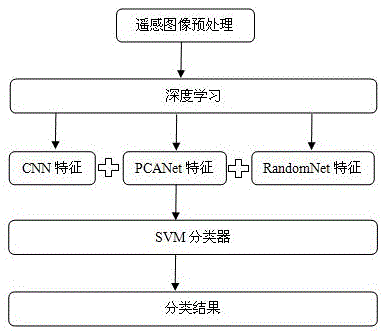
[0032] Step 1, remote sensing image preprocessing.

[0033] This step includes preprocessing of remote sensing image training samples and remote sensing image test data.

[0034] The preprocessing of remote sensing image training samples includes extracting scene units and defining scene categories by artificial vision. First, the large-scale remote sensing image training sample is divided into several image sub-blocks of the same size to obtain the scene unit training sample; then the scene category of each scene unit training sample is defined by artificial visual inspection, and is marked with a label, the scene category in the present invention Only forest and non-forest classes are included. The preprocessing of remote sensing image test...


PUM


Abstract

The present invention discloses a remote sensing image power transmission line corridor forest region extraction method. The method comprises the steps of (1) training an SVM classifier: extracting a scene unit training sample from a remote sensing training sample and using an artificial visual way to define the scene category of each scene unit training sample and carrying marking by using a mark number; extracting the global characteristic of each scene unit training sample; and combining the scene category mark number of the scene unit training sample and the global characteristic to train the SVM classifier, (2) using the trained SVM classifier to classify the remote sensing image test data: extracting a scene unit from the remote sensing image test data; extracting the global characteristic of each scene unit; and using the trained SVM classifier to extract a forest region based on the global characteristic combination of the scene units. According to the method, the completeness of extracted object description can be enhanced, and thus the accuracy of the forest area extraction is improved.

Description

technical field [0001] The invention belongs to the technical field of intelligent analysis of remote sensing images, and in particular relates to a method for extracting forest areas of transmission line corridors of remote sensing images. Background technique [0002] Transmission lines are the lifeblood of power grid operation and the "lifeline" related to the national economy and people's livelihood. With the rapid development of my country's national economy, the construction of my country's power grid has entered a new era. Ultra-high voltage transmission lines have become the main grid frame of my country's power grid, and UHV transmission lines have also been built and put into operation one after another. It is worth noting that when the transmission line passes through forest areas, because there are many trees and weeds in the corridor of the transmission line, it is very easy to cause wildfires during long droughts and no rain, spring plowing and land reclamatio...

Claims


Application Information

Patent Timeline
IPC IPC(8): G06K9/62
CPCG06F18/2411
Inventor 徐侃张校志陈志国李陶
Owner WUHAN UNIV
Features
  • Generate Ideas
  • Intellectual Property
  • Life Sciences
  • Materials
  • Tech Scout
  • Unparalleled Data Quality
  • Higher Quality Content
  • 60% Fewer Hallucinations
Learn More