Multisensor fusion-based nmanned aerial vehicle SLAM (simultaneous localization and mapping) navigation method and system

A multi-sensor fusion and navigation method technology, applied in the field of UAV SLAM navigation method and system, can solve the problems of easy loss of feature point matching, high noise, and low recognition ability of small obstacles

Active Publication Date: 2018-11-16
BEIJING FORESTRY UNIVERSITY
View PDF8 Cites 47 Cited by
  • Summary
  • Abstract
  • Description
  • Claims
  • Application Information

AI Technical Summary

Problems solved by technology

However, existing SLAMs have certain limitations. Existing monocular visual SLAMs, such as LSD-SLAM and ORB-SLAM, have disadvantages such as easy loss of feature point matching and slow matching speed in a single background environment; Visual SLAM has relatively high requirements for algorithms and airborne hardware...

Method used


Image

  • Multisensor fusion-based nmanned aerial vehicle SLAM (simultaneous localization and mapping) navigation method and system
  • Multisensor fusion-based nmanned aerial vehicle SLAM (simultaneous localization and mapping) navigation method and system
  • Multisensor fusion-based nmanned aerial vehicle SLAM (simultaneous localization and mapping) navigation method and system

Examples


Embodiment Construction

[0064] In order to make the object, technical solution and advantages of the present invention clearer, the present invention will be described in further detail below in conjunction with specific embodiments and with reference to the accompanying drawings.

[0065] It should be noted that all expressions using "first" and "second" in the embodiments of the present invention are to distinguish two entities with the same name but different parameters or parameters that are not the same, see "first" and "second" It is only for the convenience of expression, and should not be construed as a limitation on the embodiments of the present invention, which will not be described one by one in the subsequent embodiments.

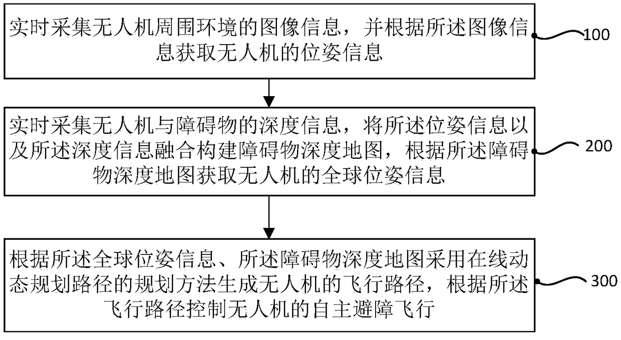
[0066] figure 1 It is a flowchart of a multi-sensor fusion-based SLAM navigation method for an unmanned aerial vehicle according to an embodiment of the present invention.

[0067] In one embodiment of the present invention, the multi-sensor fusion-based unmanned aer...


PUM


Abstract

The invention discloses a multisensor fusion-based unmanned aerial vehicle SLAM (simultaneous localization and mapping) navigation method and a multisensor fusion-based unmanned aerial vehicle SLAM navigation system. The multisensor fusion-based unmanned aerial vehicle SLAM navigation method comprises the following steps: acquiring image information of the surrounding environment of an unmanned aerial vehicle in real time, and acquiring pose information of the unmanned aerial vehicle according to the image information; acquiring depth information of the unmanned aerial vehicle and an obstaclein real time, fusing the pose information and the depth information to construct an obstacle depth map, and acquiring global position information of the unmanned aerial vehicle according to the obstacle depth map; according to the global pose information and the obstacle depth map, generating a flight path of the unmanned aerial vehicle by an online dynamic path planning method, and controlling autonomous obstacle-avoiding flight of the unmanned aerial vehicle according to the flight path. Through the multisensor fusion-based unmanned aerial vehicle SLAM navigation method and the multisensor fusion-based unmanned aerial vehicle SLAM navigation system, real-time localization and mapping of the unmanned aerial vehicle in a complex environment can be achieved; compared with the conventional unmanned aerial vehicle navigation technology, the navigation technology adopted by the invention has the advantages as follows: real-time localization and mapping and autonomous navigation are achieved, and the intelligence degree and the navigation accuracy of the unmanned aerial vehicle are improved.

Description

technical field [0001] The invention relates to the technical field of navigation positioning and control, in particular to a multi-sensor fusion-based SLAM navigation method and system for an unmanned aerial vehicle. Background technique [0002] Unmanned Aerial Vehicle (UAV) is an unmanned aerial vehicle controlled by radio remote control equipment and its own program. In recent years, the wide application of unmanned aerial vehicle (UAV) in many fields has attracted people's attention. For example, it can carry out reconnaissance and attack in the military; A type of unmanned aerial vehicle, which has the characteristics of good maneuverability, simple structure, and stable control, and is suitable for flight operations in complex environments. For drone navigation, the most critical link is how to obtain the pose information of the drone. [0003] Traditional UAV navigation technologies, such as GPS, inertial sensors, ultrasonic sensors and other technologies, are base...

Claims


Application Information

Patent Timeline
IPC IPC(8): G01C21/20
CPCG01C21/20
Inventor 张军国胡春鹤夏雨宋鸣杜科
Owner BEIJING FORESTRY UNIVERSITY
Why Eureka
Try Eureka