Method and device of aero-photography field work

A kind of aerial photography and field technology, applied in the field of aerial photogrammetry, can solve the problems of low design efficiency and poor design precision of aerial photography plan, and achieve the effect of high design efficiency and design precision

Active Publication Date: 2016-05-11
中科卫星山东科技集团有限公司
View PDF2 Cites 18 Cited by
  • Summary
  • Abstract
  • Description
  • Claims
  • Application Information

AI Technical Summary

Problems solved by technology

[0005] The present invention provides a method and device for aerial photography field work, which is used to solve the problem of low design efficiency and poor design accuracy of ae

Method used


Image

  • Method and device of aero-photography field work
  • Method and device of aero-photography field work
  • Method and device of aero-photography field work

Examples


Embodiment Construction

[0027] In order to solve the problems that the prior art aerial photography field design methods all require manual participation, the design efficiency is low, the design accuracy is poor, and there is no aerial photography method that can automatically adjust the aerial photography route and exposure point design, the present invention provides a A method and device for the field of aerial photography, the present invention will be further described in detail below in conjunction with the accompanying drawings and embodiments. It should be understood that the specific embodiments described here are only used to explain the present invention, not to limit the present invention.

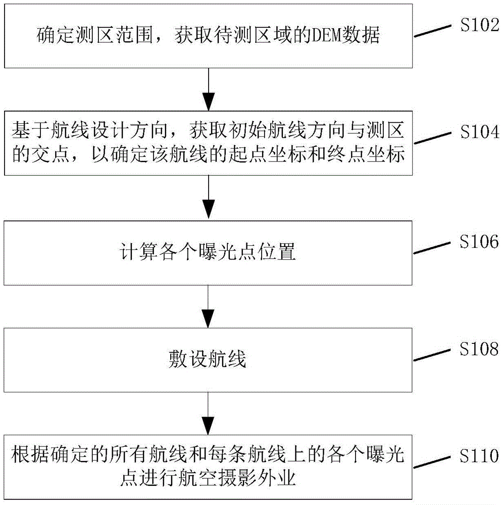
[0028] An embodiment of the present invention provides a field method for aerial photography, the flow of the method is as follows figure 1 As shown, including steps S102 to S110:

[0029] S102, determining the scope of the survey area, and acquiring DEM data of the area to be surveyed;

[0030] S1...


PUM


Abstract

The invention discloses a method and device of aero-photography field work. The method comprises the following steps: according to the range of measuring zone, obtaining the DEM data of a region to be measured; obtaining the intersection point between an initial air line direction and the measuring zone so as to determine the start point coordinate and the end point coordinate of the air line; setting the start point coordinate as the initial exposure point of the air line, according to the DEM data, calculating the coordinates of each exposure point in the air line in sequence until the calculated coordinate of the current exposure point is larger than the coordinate of the end point of the air line, determining the current exposure point as the last exposure point of the air line; taking the air line as the initial air line, laying air lines in sequence by taking the overlapping degree, which is calculated according to the DEM data, as the constraint until the lateral direction coordinate value of the current air line is not in the range of maximal coordinate value and minimal coordinate value of the lateral direction of the measuring zone, and determining the current air line as the last air line in the measuring zone.

Description

technical field [0001] The invention relates to the field of aerial photogrammetry, in particular to a method and device for aerial photogrammetry. Background technique [0002] When designing routes and exposure points for traditional area-scan camera aerial photography, generally one-half of the sum of the average elevations of several representative ground high points and the average elevations of ground low points in the shooting area is used as the datum elevation, or manually estimated Input the datum elevation of this place; based on this datum, according to the ground resolution required in the survey area, the focal length of the camera and the CCD (Charge-coupled Device) pixel size, the size of the CCD area array, and the lateral and heading overlap Determine the relative flight height and absolute flight height, course distance and side distance of the route; design the route based on the fixed side distance, generate the exposure point position based on the fixed...

Claims


Application Information

Patent Timeline
IPC IPC(8): G01C11/00
CPCG01C11/00
Inventor 赵海涛黎东左正立张兵陈正超
Owner 中科卫星山东科技集团有限公司
Why Eureka
Try Eureka