Method for automatic correction of digital ground elevation model for low-altitude aerial photogrammetry

A ground elevation model, aerial photography technology, applied in measurement devices, photo interpretation, image data processing and other directions, can solve problems affecting the interpretation and extraction of target buildings, blur, height discontinuity, etc.

Active Publication Date: 2016-05-25
KUNSHAN DIGITAL CITY INFORMATION TECH
View PDF4 Cites 8 Cited by
  • Summary
  • Abstract
  • Description
  • Claims
  • Application Information

AI Technical Summary

Problems solved by technology

[0008] If the DSM is not processed, the height of the edge of the building is discontinuous, which will lead to obvious jagged deformation and edge blur on the edge of the ge

Method used


Image

  • Method for automatic correction of digital ground elevation model for low-altitude aerial photogrammetry
  • Method for automatic correction of digital ground elevation model for low-altitude aerial photogrammetry
  • Method for automatic correction of digital ground elevation model for low-altitude aerial photogrammetry

Examples


Embodiment Construction

[0032] The present invention will be further described below in conjunction with specific embodiments.

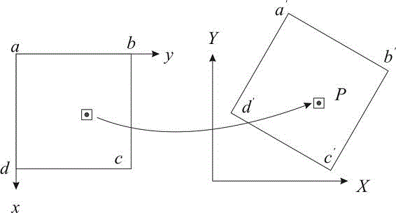
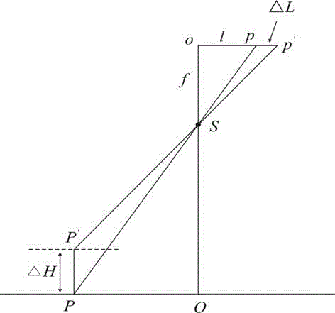
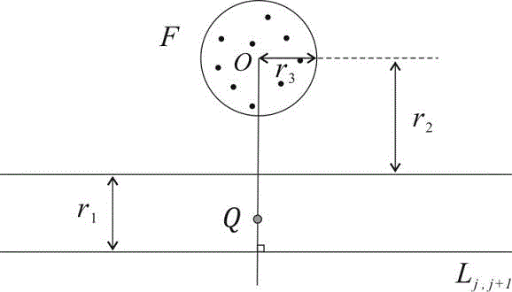
[0033] see Figure 1 to Figure 6 As shown, the present invention provides a kind of method for automatically correcting the digital ground elevation model of low-altitude aerial photogrammetry, comprising the following steps:

[0034] a) Generating a digital surface point cloud model from digital aerial images of targets captured by low-altitude drones;

[0035] b) Extract target points with steep elevation changes in the digital surface point cloud model;

[0036] c) using the target point extracted in step "b)" to extract the edge contour of the target object;

[0037] d) Correcting the elevation value of the object edge contour extracted in step "c)".

[0038] Among them, in step b), the target point is extracted according to the following method: set the target point as several different undetermined points P, the edge point set of the undetermined point P is M, the ...


PUM


Abstract

The invention discloses a method for automatic correction of a digital ground elevation model for low-altitude aerial photogrammetry. The method comprises the steps of: a) generating a digital surface model point cloud by using a digital aerial image of an object captured by a low-altitude UAV; b) extracting target points with elevation abrupt change in the digital surface model point cloud; c) extracting an object edge contour line by using targets point extracted in the step b); and d) correcting the elevation value of the object edge contour line extracted in the step c). The invention utilizes the ground surface height model point cloud data to extract the edge contour line of a building and conduct regularization processing, so as to establish a digital elevation model; and digital differential rectification is carried out on this basis to generate an orthoimage. The method not only can effectively eliminate the jagged distortion at the edge of the abrupt change position of the building elevation in the orthoimage and beautify the orthoimage, but also ensures the plane accuracy of orthoimage and greatly promotes the application of low-altitude UAV aerial photogrammetry technology.

Description

technical field [0001] The invention relates to a method for automatically correcting a digital ground elevation model in low-altitude aerial photogrammetry. Background technique [0002] With the development of science and technology, UAV low-altitude aerial photogrammetry technology is widely used in the surveying and mapping industry due to its advantages of low cost, fast and flexible, high-resolution images, and low requirements for take-off and landing conditions. It is used to measure houses, elevated highways, etc. The shape and location of the building. The low flying height and small base-to-height ratio of the UAV can easily lead to large projection errors in the captured images. For buildings with abrupt elevation changes at the edge points in the vertical direction, the captured image projection errors are even greater. [0003] The principle of solving the pixel value of the digital orthophoto map (Digital OrthophotoMap, DOM for short) in the prior art is as f...

Claims


Application Information

Patent Timeline
IPC IPC(8): G01C25/00G01C11/04G06T5/00
CPCG01C11/04G01C25/00G06T5/002G06T2207/10004
Inventor 朱彩英陈良浩徐昕东徐青蓝朝帧朱杰
Owner KUNSHAN DIGITAL CITY INFORMATION TECH
Why Eureka
Try Eureka