Longitudinal positioning system and method based on city road marking map in automatic driving

A road marking and automatic driving technology, which is applied in satellite radio beacon positioning system, radio wave measurement system, measuring device, etc., can solve the problem of inability to achieve high-precision positioning at the lane level, and achieve good robustness and practical areas broad effect

Active Publication Date: 2016-06-15
WUHAN KOTEI TECH CORP
View PDF7 Cites 42 Cited by
  • Summary
  • Abstract
  • Description
  • Claims
  • Application Information

AI Technical Summary

Problems solved by technology

However, due to factors such as steering, wheels or encoders slipping during driving, the positioning system integrating GNSS and INS still cannot meet the needs of high-precision positioning at the lane level in urban road sections

Method used


Image

  • Longitudinal positioning system and method based on city road marking map in automatic driving
  • Longitudinal positioning system and method based on city road marking map in automatic driving
  • Longitudinal positioning system and method based on city road marking map in automatic driving

Examples


Embodiment Construction

[0040] In order to make the above objectives, features and advantages of the present invention more obvious and understandable, the specific embodiments of the present invention will be described in detail below with reference to the accompanying drawings.

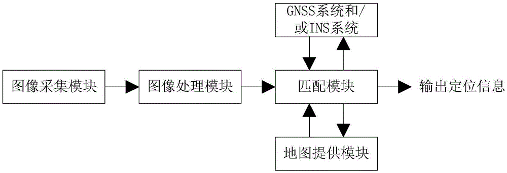
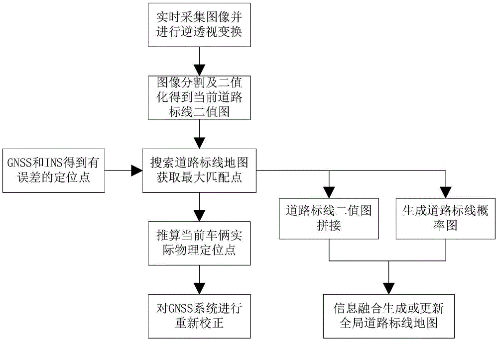
[0041] See figure 1 This figure is a schematic structural diagram of a longitudinal positioning system based on a city road marking map provided by an embodiment of the present invention, and the system includes:

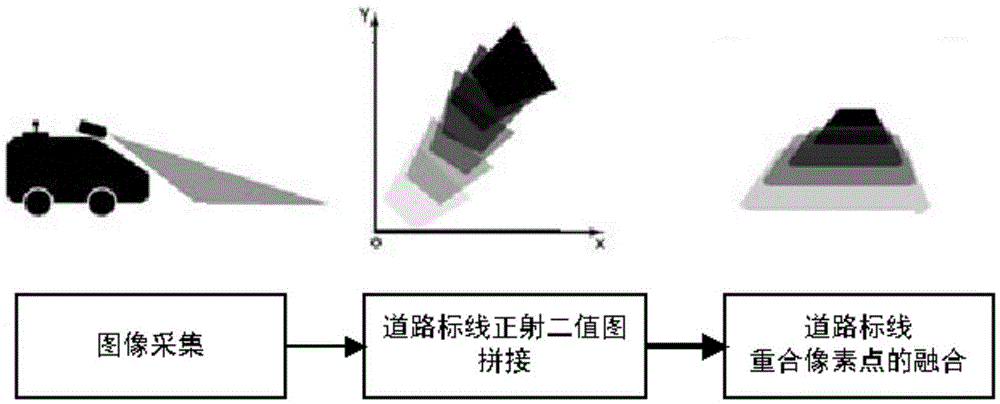
[0042] The image acquisition module is used to collect the image in front of the vehicle. In this module, the height of the camera from the ground h when the camera is installed, and the angle between the camera field of view and the ground is marked by theta, such Figure 5 Shown

[0043] The image processing module is used to process the collected images of the front of the vehicle to obtain a bird's-eye view of the current front of the vehicle and a binary image of the pixel classification of the road markings ahead...


PUM


Abstract

The invention provides a longitudinal positioning system and method based on a city road marking map in automatic driving. Through current road marking information collected by an intelligent driving vehicle, and based on locating point coordinates currently given by a GNSS which have an error, longitudinal positioning of the vehicle based on the road marking map is further performed in the vicinity of the current locating point coordinates, thereby correcting and repositioning the current accurate position of the vehicle, and on a structured road in a complex environment of a city, the absolute position of static road markings can be utilized to perform auxiliary correction of GNSS positioning and eliminate an accumulated error of an INS system.

Description

Technical field [0001] The invention relates to the technical field of intelligent driving, in particular to a longitudinal positioning system and method based on a city road marking map in automatic driving. Background technique [0002] For the field of intelligent driving and assisted safe driving, the vehicle's own navigation and positioning are indispensable basic functions. Vehicle self-navigation can solve how to automatically, economically and conveniently plan the driving route between the origin and destination in intelligent driving; vehicle self-positioning determines whether the route planned by the navigation can be accurately, Complete the driving action of automatic driving safely and quickly. [0003] At this stage, the more widely used navigation technology relies on traditional, low-precision, road-level map data, which is generated by surveying and mapping image data collected by aircraft and satellites. Generally speaking, it is completely impossible to detect...

Claims


Application Information

Patent Timeline
Patent Type & Authority Applications(China)
IPC IPC(8): G01S19/47G01S19/40
CPCG01S19/40G01S19/47
Inventor 苏晓聪陶靖琦朱敦尧
Owner WUHAN KOTEI TECH CORP
Why Eureka
Try Eureka