Non-safety zone automatic identification and automatic drawing method for safe range maps

An automatic identification and automatic drawing technology, applied in the field of safe shooting, can solve the problems of manual completion of the drawing process, unfavorable promotion, and low efficiency.

Inactive Publication Date: 2016-07-27
TIANJIN UNIV
View PDF4 Cites 7 Cited by
  • Summary
  • Abstract
  • Description
  • Claims
  • Application Information

AI Technical Summary

Problems solved by technology

At present, Shandong, Xinjiang and other places have drawn safe shooting boundary maps, but t

Method used


Image

  • Non-safety zone automatic identification and automatic drawing method for safe range maps
  • Non-safety zone automatic identification and automatic drawing method for safe range maps
  • Non-safety zone automatic identification and automatic drawing method for safe range maps

Examples


Embodiment Construction

[0084] For achieving the purpose of the present invention, technical scheme of the present invention is:

[0085] Step 1: Obtaining Google Maps

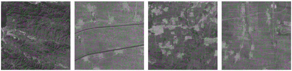
[0086] The area mainly discussed in the present invention is the Tianjin area, so utilize the map downloader to download the Google map tiles in the Tianjin area with the operating point as the center and within a radius of 10 kilometers (the Google map is made up of the resolution size called "tiles" All are 256×256 pictures seamlessly spliced). figure 1 is the downloaded original map tile.

[0087] Step 2: Defog

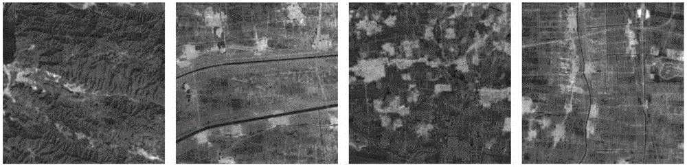
[0088] There are impurities in the air, and the downloaded Google map tiles are not clear. In order to improve the accuracy of recognition, it is necessary to dehaze the obtained Google map tiles first. figure 2 It is the effect picture after removing the fog.

[0089] Step 3: Grayscale

[0090] The Google map after defogging processing is still a color image. In order to identify the location of non-safe areas (po...


PUM


Abstract

The invention relates to the technical field of safe range in mankind's endeavor to influence weather and more particularly, to non-safety zone automatic identification and automatic drawing method for safe range maps. According to the method, it is possible to do automatic identification to the non-safety zones on a Google map and to automatically draw safe range maps at high efficiency and accuracy. There advantages enable the method to be promoted conveniently. The method can be performed through the following steps of accessing a Google map (step 1); de-blurring (step 2), gray processing (step 3), segmentation processing (step 4), de-noising (step 5), tiled maps splicing (step 6) step 2, step 3, step 4, step 5 and step 6 to form the automatic identification process for non-safety zones and automatically drawing safe range maps (step 7). The invention finds applications where mankind endeavors to influence weather.

Description

technical field [0001] The invention relates to the technical field of safe shooting boundaries in artificial weather modification, in particular to an automatic identification of non-safe areas and an automatic drawing method of a safe shooting boundary map. Background technique [0002] my country has a vast territory, complex terrain, and diverse climate types but poor stability, so it is seriously affected by meteorological disasters. Statistics show that in recent years, meteorological disasters have caused hundreds of millions of economic losses to my country every year. In order to reduce the losses caused by meteorological disasters, artificial weather modification is more and more applied to production and life. Artificial weather modification is the use of human factors to intervene in the weather, reduce the adverse effects of meteorological disasters, and use scientific and technological means and climate resources to achieve activities such as artificial rainfa...

Claims


Application Information

Patent Timeline
IPC IPC(8): G06T3/40G06T5/00G06T7/00G06T11/20
CPCG06T3/4038G06T5/003G06T11/206G06T2207/10004G06T2207/10024G06T2207/30181
Inventor 路志英李笑冬
Owner TIANJIN UNIV
Why Eureka
Try Eureka