Functional region dividing method and device based on remote-sensing image

A technology of remote sensing image and functional area, applied in the direction of instruments, character and pattern recognition, computer parts, etc., can solve the problems of single satellite data accuracy, low, limitation, etc., and achieve the effect of significant application value

Inactive Publication Date: 2016-08-03
MIN OF CIVIL AFFAIRS NAT DISASTER REDUCTION CENT +1
View PDF2 Cites 2 Cited by
  • Summary
  • Abstract
  • Description
  • Claims
  • Application Information

AI Technical Summary

Problems solved by technology

[0005] Aiming at the technical problem that the functional area division method in the prior art is only limited to a single satellite data and the accuracy is not high, the present invention provides a functional area division method based on remote sensing images, which is characterized in that the method includes: extracting Scale-invariantfeaturetransform (SIFT) features of the remote sensing image to be id

Method used


Image

  • Functional region dividing method and device based on remote-sensing image
  • Functional region dividing method and device based on remote-sensing image
  • Functional region dividing method and device based on remote-sensing image

Examples


Example Embodiment

[0019] The specific embodiments of the present invention will be described in detail below with reference to the accompanying drawings. It should be understood that the specific embodiments described herein are only used to illustrate and explain the present invention, and not to limit the present invention.

[0020] The following will illustrate the idea of ​​the present invention with examples, but it should be understood that these examples are non-limiting examples, and the protection scope of the present invention is not limited to this:

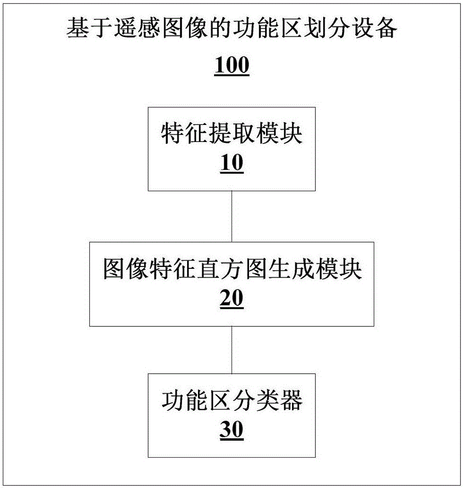
[0021] In order to illustrate the idea of ​​the present invention more clearly, a detailed description will be given by taking a remote sensing image-based functional area dividing device as an example. figure 1 It is a schematic structural diagram of a remote sensing image-based functional area division device according to an embodiment of the present invention, such as figure 1 As shown, the remote sensing image-based functional area dividi...


PUM


Abstract

The invention discloses a functional region dividing method and device based on a remote-sensing image, and relates to the technical field of artificial intelligence. The method comprises that an SIFT (Scale-invariant feature transform) feature is extracted from the remote-sensing image to be identified; according to the SIFT feature of the remote-sensing image to be identified as well as an image feature expression dictionary, an image feature histogram of the remote-sensing image to be identified is generated; and according to the image feature histogram and a functional region classifier, a functional region of the remote-sensing image to be identified is determined. According to the invention, city functional areas of different satellite data can be divided automatically, rapidly, conveniently and accurately, and automatic functional region division has substantial application values in the aspects including city planning, disaster prevention, emergent disaster rescue and business investigation.

Description

technical field [0001] The invention relates to the technical field of artificial intelligence, in particular to a method for dividing functional areas based on remote sensing images and a device for dividing functional areas based on remote sensing images. Background technique [0002] With the vigorous development of high-resolution remote sensing satellites in recent years, the multi-spectral satellite data used in large quantities by environmental remote sensing satellites is being replaced by new data with high resolution and fewer spectra. Many positive changes are taking place in the field of environmental remote sensing . The new high-resolution satellites can provide sub-meter resolution accuracy, which is greatly improved compared with traditional multi-spectral remote sensing satellites. These new data can clearly distinguish the size, shape, and even appearance characteristics of buildings on the ground. It has significant potential in urban planning, disaster ...

Claims


Application Information

Patent Timeline
IPC IPC(8): G06K9/00G06K9/46
CPCG06V20/176G06V10/462
Inventor 汤童刘庆杰范一大李苓苓王蕴红温奇王薇王平张正欣张薇林月冠崔燕黄河
Owner MIN OF CIVIL AFFAIRS NAT DISASTER REDUCTION CENT
Why Eureka
Try Eureka