Method for generating urban space big data map on basis of POI commercial form data

A technology for data generation and large space, which is applied in the fields of electronic digital data processing, structured data retrieval, geographic information database, etc. Guarantee scientific and avoid the effect of data omission

Active Publication Date: 2016-08-24
SOUTHEAST UNIV
View PDF6 Cites 16 Cited by
  • Summary
  • Abstract
  • Description
  • Claims
  • Application Information

AI Technical Summary

Problems solved by technology

[0004] At present, there are many ways to obtain POI. However, due to the complexity of the obtained information, it cannot fully meet the needs...

Method used


Image

  • Method for generating urban space big data map on basis of POI commercial form data
  • Method for generating urban space big data map on basis of POI commercial form data
  • Method for generating urban space big data map on basis of POI commercial form data

Examples


Embodiment Construction

[0034] Below in conjunction with accompanying drawing and specific embodiment, further illustrate the present invention, should be understood that these embodiments are only for illustrating the present invention and are not intended to limit the scope of the present invention, after having read the present invention, those skilled in the art will understand various aspects of the present invention Modifications in equivalent forms all fall within the scope defined by the appended claims of this application.

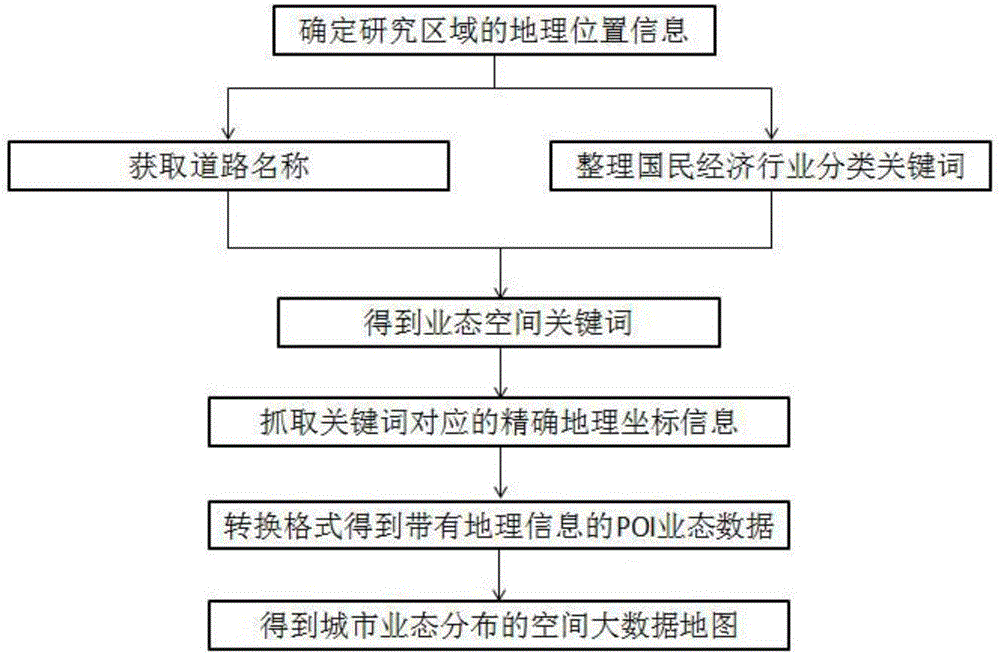
[0035] Aiming at the shortcomings of the current method of using urban big data to generate urban space maps, such as the imprecise selection of keywords, the present invention proposes a method for generating urban space big data maps based on POI format data, which consists of the following steps: determining the scope of the research area According to the geographical location information of the research area, obtain the road names within the research scope; according ...


PUM


Abstract

The invention discloses a method for generating an urban space big data map on the basis of POI commercial form data. The method comprises the steps that names of roads in a study range are firstly acquired; according to national economy industry classification types, keywords corresponding to the types are sorted; commercial form space keywords in the study range are obtained by combining the road names with the industry keywords; the commercial form space keywords are input in a map website, precise geographical coordinate information corresponding to the commercial form space keywords in the map website is captured, and the POI commercial form data with geographical coordinates in the region range is acquired and then converted into a dot format with information; POI information dots and a space digital map of the study region are superposed through ArcGIS software, and the urban commercial form distribution space big data map is obtained. By applying the urban space big data map generated through the method, a simple and visualized model can be obtained, and through classification keyword selection in the method, not only is the systematicness of commercial form space data POI guaranteed, but also data missing is avoided.

Description

technical field [0001] The invention belongs to the technical field of urban planning, and relates to a method for generating urban spatial big data maps based on POI business data. Background technique [0002] With the rapid development of modern information technology in recent years, digital technology and network technology have penetrated into all aspects of urban life, modern urban planning, construction and management have undergone historic changes, and the efficient sharing and operation of spatial big data has realized Co-construction and sharing of spatial data resources. The analysis and mining of big data provides a more scientific and reasonable forecast and reference for the formation and development of urban industries. [0003] POI is the abbreviation of Point of Interest, which is a kind of point data representing real geographic entities. POI generally contains basic information such as name, category, latitude and longitude, and address. The rise of PO...

Claims


Application Information

Patent Timeline
IPC IPC(8): G06F17/30
CPCG06F16/29G06F16/9537
Inventor 杨俊宴李晋
Owner SOUTHEAST UNIV
Why Eureka
Try Eureka