A multi-indicator fusion landslide detection method based on high-resolution remote sensing images

A remote sensing image, high-resolution technology, applied in instrumentation, computing, character and pattern recognition, etc., to achieve the effect of strong applicability

Active Publication Date: 2019-07-05
TONGJI UNIV
View PDF2 Cites 0 Cited by
  • Summary
  • Abstract
  • Description
  • Claims
  • Application Information

AI Technical Summary

Problems solved by technology

However, for complex features such as landslides, only using information such as spectrum and texture for extraction has great limitations.

Method used


Image

  • A multi-indicator fusion landslide detection method based on high-resolution remote sensing images
  • A multi-indicator fusion landslide detection method based on high-resolution remote sensing images
  • A multi-indicator fusion landslide detection method based on high-resolution remote sensing images

Examples


Embodiment Construction

[0035] The present invention will be described in detail below in conjunction with the accompanying drawings and specific embodiments.

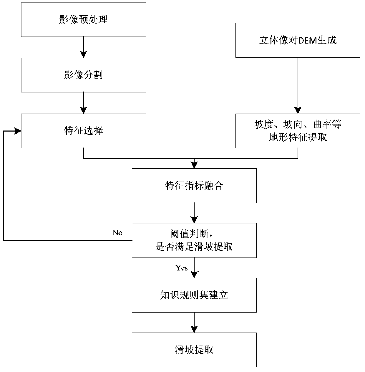
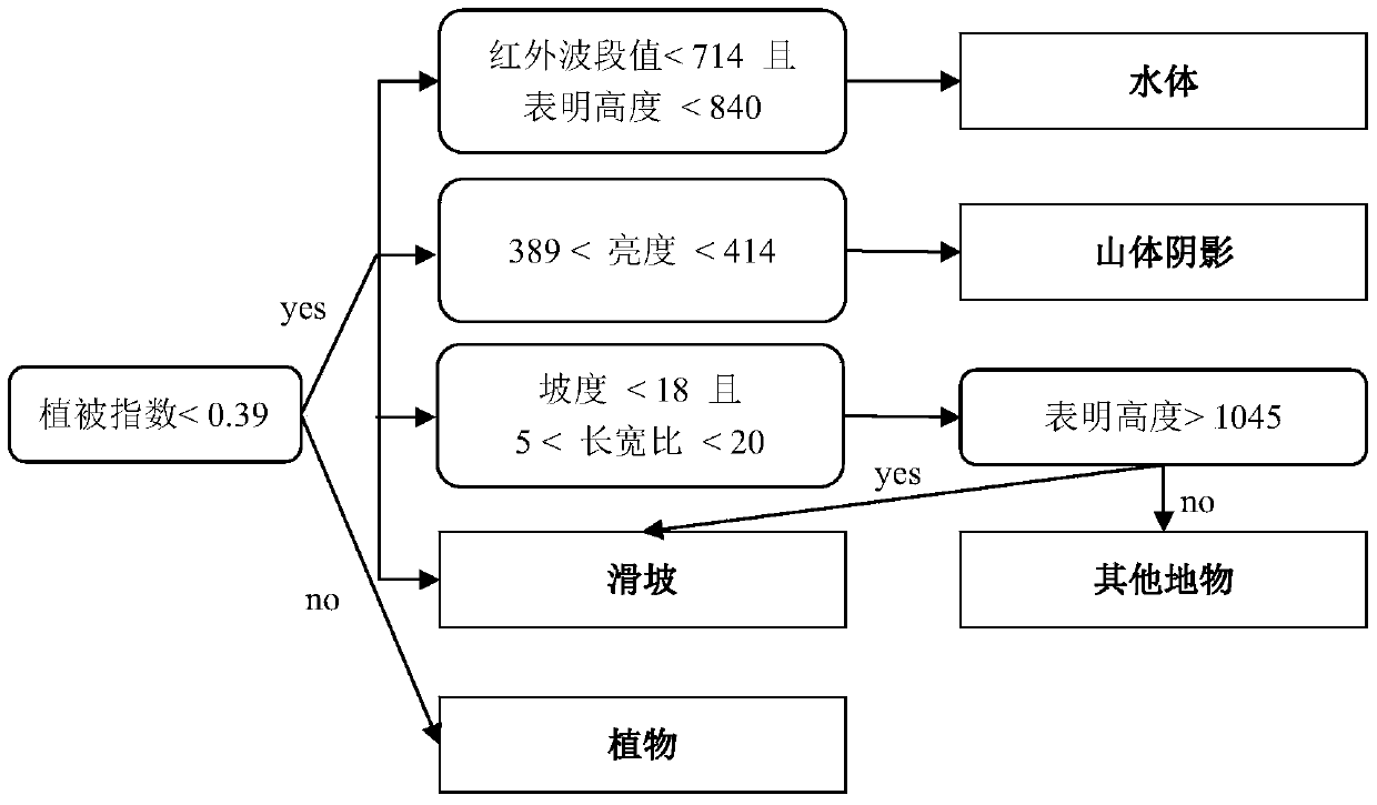
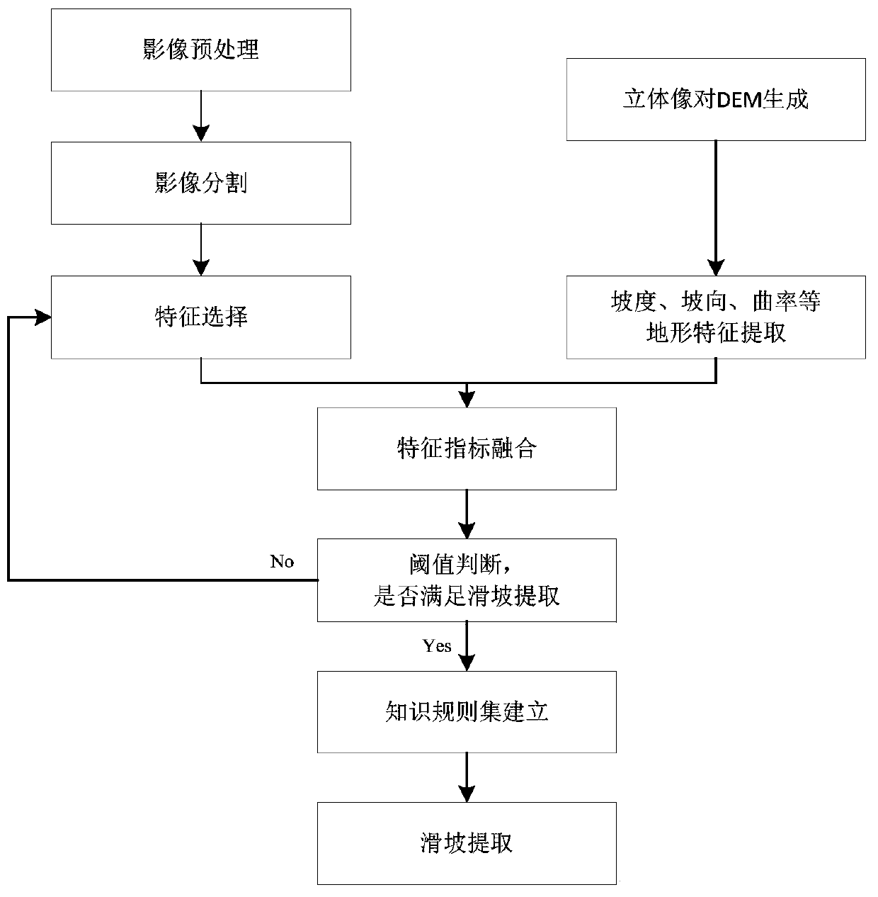
[0036] figure 1 The specific process of this method is shown, and IKONOS images can be used to extract landslides in the research area of ​​Hongkou Township, Dujiangyan City. The detailed steps are described as follows:

[0037] 1. Perform radiation correction on IKONOS images;

[0038] 2. Use the IKONOS stereo image pair to generate a digital elevation model, and generate terrain feature maps such as slope, aspect, and curvature through the digital elevation model;

[0039] 3. Combined with the digital elevation model to perform orthorectification on the IKONOS image after radiation;

[0040] 4. Enhance the IKONOS image, and use the panchromatic band and multi-spectral band for registration and fusion to generate a synthetic image with high resolution and rich spectral information;

[0041] 5. Merge the fused IKONOS image with digital ele...


PUM


Abstract

The present invention relates to a high-resolution remote sensing image-based multi-index fusion landslide detection method, which comprises the steps of (1) acquiring a high-resolution remote sensing image and a stereoscopic image pair; (2) generating a digital elevation model and calculating terrain feature indexes; (3) preprocessing the remote sensing image; (4) conducting the multi-scale image segmentation for the remote sensing image; (5) selecting appropriate terrain feature indexes for different scale layers and obtaining the values of the terrain feature indexes; (6) conducting the fusion processing for terrain feature indexes and ground object feature indexes, and comparing each feature index with a preset rule set to realize the landslide detection. Compared with the prior art, the noise influence caused by the scattered distribution of landslide regions can be avoided, so that the landslide recognition and extraction problem caused by earthquakes or other natural damages can be solved. Therefore, the method provides support for the post-disaster reconstruction and restoration. The above feature indexes can reflect the features of a ground object within a selected region, and a threshold corresponding to the feature indexes is unique. Based on the combination of features and the determination of the threshold, the landslide region can be successfully extracted and studied.

Description

technical field [0001] The invention relates to a landslide detection method, in particular to a multi-index fusion landslide detection method based on high-resolution remote sensing images. Background technique [0002] Using remote sensing technology to extract landslide information is an effective means to quickly detect, analyze and detect landslides. The traditional landslide cataloging work based on earth observation data mainly relies on image visual interpretation and field survey. This method has the disadvantages of time-consuming and expensive, and it is difficult to conduct field surveys in a short time after landslides occur in some areas. It also hinders rapid response after disasters occur. The use of high-resolution satellite images provides a strong foundation for the automatic extraction of geospatial objects, and also greatly improves the extraction accuracy of landslide information. The amount of information is relatively small, and a large amount of im...

Claims


Application Information

Patent Timeline
Patent Type & Authority Patents(China)
IPC IPC(8): G06K9/00
Inventor 童小华陆平曹文
Owner TONGJI UNIV
Why Eureka
Try Eureka