Video eagle-eye map presentation method and device

An eagle-eye image and video technology, applied in the field of video eagle-eye image presentation methods and devices, can solve the problems of unintuitive and convenient analysis, and achieve the effect of fusion presentation

Active Publication Date: 2016-10-12
GUANGDONG VIMICRO +1
View PDF4 Cites 5 Cited by
  • Summary
  • Abstract
  • Description
  • Claims
  • Application Information

AI Technical Summary

Problems solved by technology

[0003] For video analysis and processing in the field of public security, the geographical location information of the video is a very important analysis reference factor, but for the analysis and processing of video in the field of public security, the existing technology is still based on its video factors and geographic location independent analysis of factors, making the analysis less intuitive and convenient

Method used


Image

  • Video eagle-eye map presentation method and device
  • Video eagle-eye map presentation method and device
  • Video eagle-eye map presentation method and device

Examples


Embodiment 1

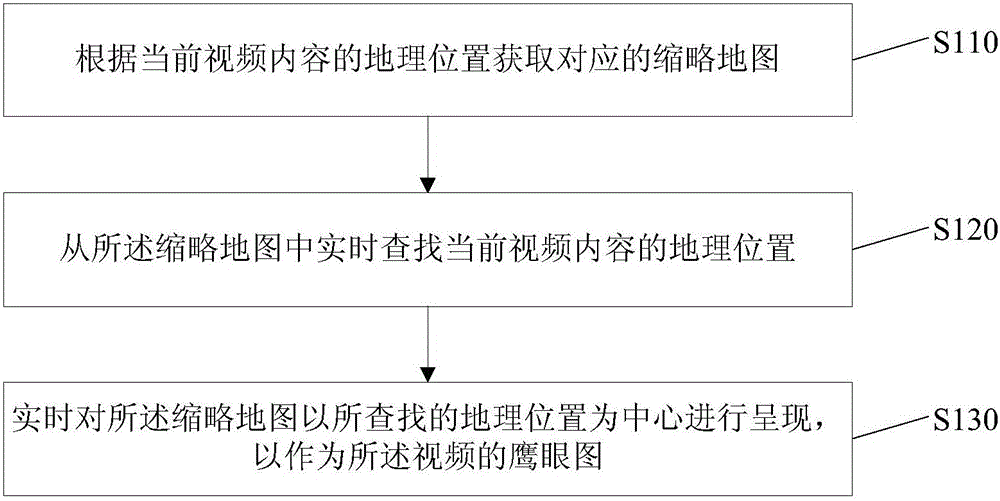
[0033] figure 1 It is a flow chart of the method for presenting a video overview map described in this embodiment. This embodiment is suitable for displaying an overview map of the geographic location of the video during video playback, and realizes the linkage between real-time video playback and the geographic location of the overview map. Case, this method can be executed by a video overview presentation device configured in a computer, such as figure 1 As shown, the method for presenting a video overview diagram in this embodiment includes:

[0034] Step S110: Obtain a corresponding thumbnail map according to the geographic location of the current video content.

[0035] There are many methods for obtaining the corresponding thumbnail map according to the geographic location of the current video content, which is not limited in this embodiment. For example, the geographic location of the video may be obtained according to the attributes of the current video (for example, the fi...

Embodiment 2

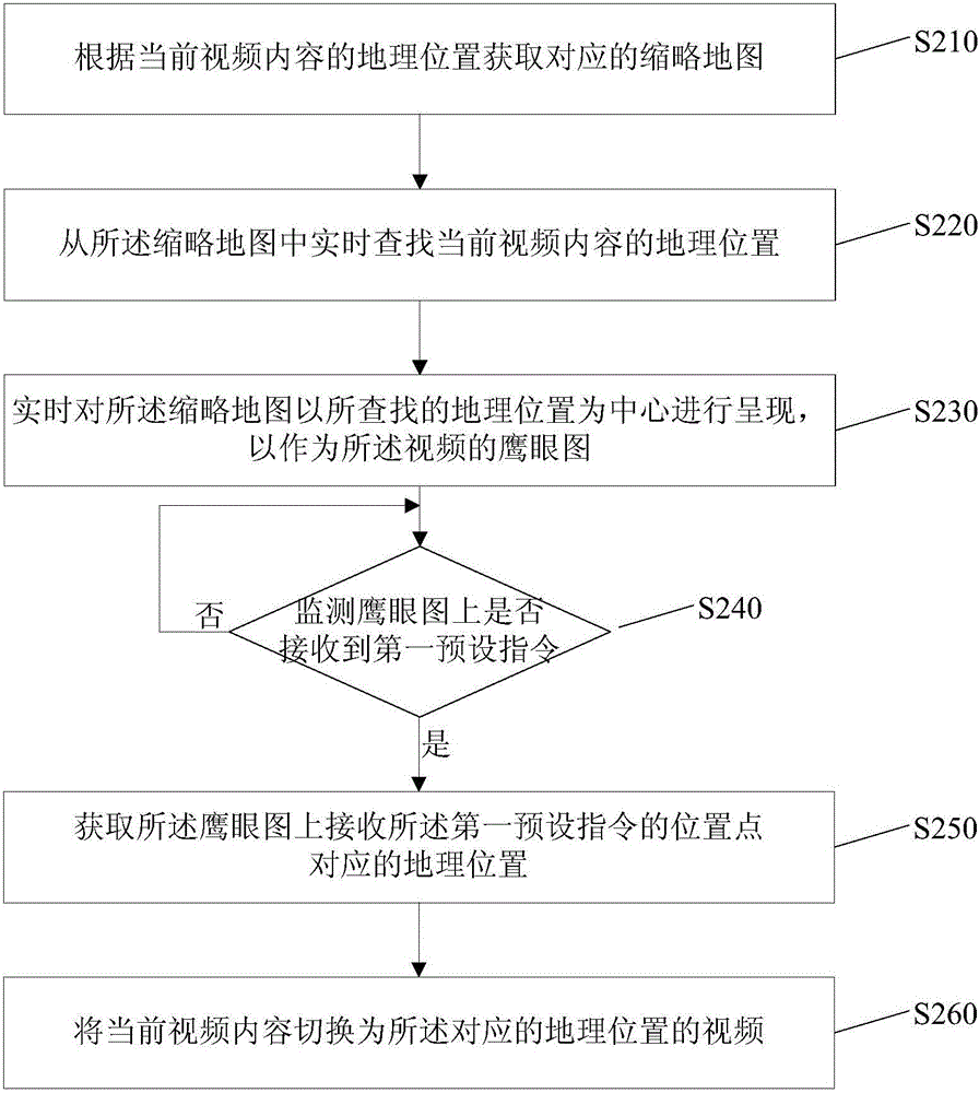
[0046] figure 2 It is the flowchart of the video overview presentation method described in this embodiment, such as figure 2 As shown, the method for presenting a video overview diagram in this embodiment includes:

[0047] Step S210: Obtain a corresponding thumbnail map according to the geographic location of the current video content.

[0048] Step S220: Find the geographic location of the current video content from the thumbnail map in real time.

[0049] Step S230: Present the thumbnail map centering on the searched geographic location in real time as an overview map of the video.

[0050] The above steps S210-S230 are the same as the steps S110-130 in the first embodiment, and will not be repeated here.

[0051] Step S240, monitoring whether the first preset instruction is received on the eagle eye chart, if yes, execute step S250, otherwise return to step S240.

[0052] In this embodiment, the preset instruction for operating the eagle eye diagram refers to a preset instruction f...

Embodiment 3

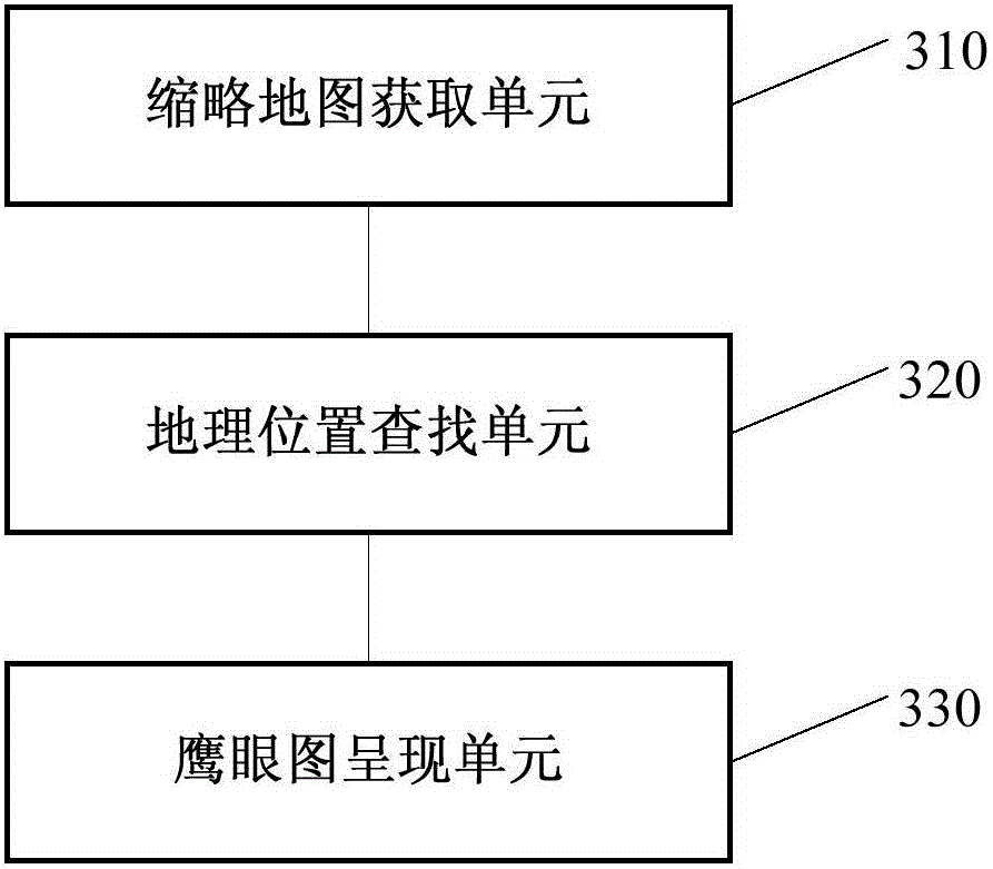
[0061] image 3 It is a structural block diagram of the video eagle-eye diagram presentation device described in this embodiment, such as image 3 As shown, the video eagle-eye diagram presentation device in this embodiment includes:

[0062] The thumbnail map obtaining unit 310 is configured to obtain a corresponding thumbnail map according to the geographic location of the current video content;

[0063] The geographic location searching unit 320 is configured to search for the geographic location of the current video content from the thumbnail map in real time;

[0064] The overview map presentation unit 330 is configured to present the thumbnail map with the searched geographic location as the center in real time as an overview map of the video.

[0065] Further, the eagle eye map presentation unit 330 is configured to display the thumbnail map in reverse color with the searched geographic location as the center in real time.

[0066] Further, the eagle eye diagram presentation unit...


PUM


Abstract

The embodiment of the invention discloses a video eagle-eye map presentation method and device. The method comprises the steps that a corresponding thumbnail map is obtained according to the geographical position of the current video content; the thumbnail map is searched for the geographical position of the current video content in real time; the thumbnail map is presented in real time by using the found geographical position as a center to be used as a video eagle-eye map. According to the technical scheme, fused presentation and rapid linkage of real-time video playing and the GIS geographical position can be achieved.

Description

Technical field [0001] The invention relates to the technical field of information processing, in particular to a method and device for presenting a video eagle eye diagram. Background technique [0002] With the development of modern society, intelligent control technology has penetrated into our lives, work and various fields, especially due to the rapid development of electronic camera technology, has a very extensive research and application in the field of public safety. These are inseparable from video recording and video-based analysis and processing in the field of public safety. [0003] For video analysis and processing in the field of public safety, the geographic location information of the video is a very important analysis reference factor, but for the analysis and processing of video in the field of public safety, the existing technology is still based on its video factors and geographic factors. The independent analysis of factors makes the analysis less intuitive ...

Claims


Application Information

Patent Timeline
Patent Type & Authority Applications(China)
IPC IPC(8): G06F17/30G06K9/00
CPCG06F16/29G06F16/56G06F16/9537G06V20/46
Inventor 宋建军纪宏达贺志刚陈超侯杰韩峻白安平劳健斌陈晋忠李权建陈忠斌张虎贾富桃邓峥郭丹宇施清平赵丽红黄强熊张永吉
Owner GUANGDONG VIMICRO
Why Eureka
Try Eureka