Method and device for collaboratively dispatching tasks among multiple earth observation satellites

A technology of earth observation and coordinated scheduling, applied in the field of earth observation satellite operation and control, can solve the problems of unreasonable utilization of satellite imaging resources, low efficiency of satellite imaging, repeated imaging and other problems, and achieve the reduction of overlapping execution of the same task and optimization Task scheduling, improving imaging efficiency and effectiveness

Inactive Publication Date: 2016-12-14
INST OF RADAR & ELECTRONICS CONFRONTATION ARMY AIR FORCE EQUIP RES INST OF PLA
View PDF2 Cites 27 Cited by
  • Summary
  • Abstract
  • Description
  • Claims
  • Application Information

AI Technical Summary

Problems solved by technology

When multiple earth observation satellites are in orbit at the same time, the imaging coverage strips of different satellites will overlap, and different satellites can take pictures of the imaging requirements in the overlapping area, and the imaging requirements in the intersection area may be allocated to all Satellites that can image them have caused the demand to be imaged repeatedly, and the use of satellite imaging resources is unreasonable
[0006] For the above-mentioned problems of low satellite imaging efficiency and unreasonable utilization of satellite imaging resources, no effective solution has been proposed yet

Method used


Image

  • Method and device for collaboratively dispatching tasks among multiple earth observation satellites
  • Method and device for collaboratively dispatching tasks among multiple earth observation satellites
  • Method and device for collaboratively dispatching tasks among multiple earth observation satellites

Examples


Embodiment 1

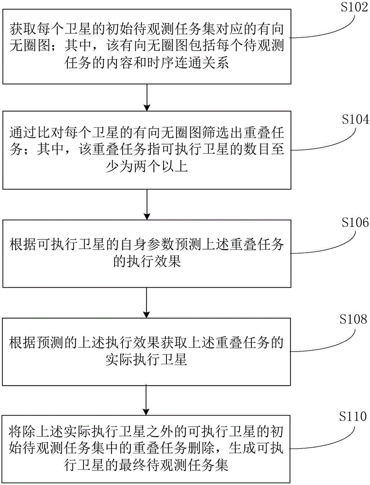
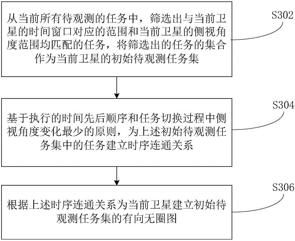
[0035] see figure 1 A flow chart of a collaborative scheduling method for tasks between multiple earth observation satellites shown, the method can be executed on a computer or a terminal, and specifically includes the following steps:

[0036] Step S102, obtaining the directed acyclic graph corresponding to the initial task set to be observed for each satellite; wherein, the directed acyclic graph includes the content and time-series connectivity of each task to be observed;

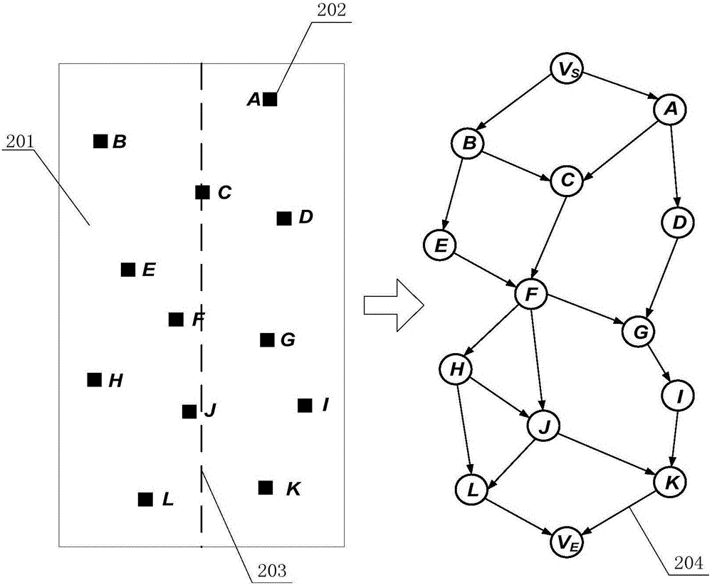
[0037] The above directed acyclic graph is also called a directed acyclic graph. Usually, if a directed graph cannot start from a certain vertex and return to the vertex through several edges, then the directed graph is a directed acyclic graph. ; This directed acyclic graph is often used to represent the driver dependencies between events, or the scheduling between management tasks.

[0038] In the embodiment of the present invention, the directed acyclic graph is used to represent the time-series con...

Embodiment 2

[0076] Corresponding to Embodiment 1 of the above-mentioned method, the embodiment of the present invention provides a coordinated scheduling device for tasks among multiple earth observation satellites. The structural diagram of the device is as follows Figure 5 As shown, the device includes the following modules:

[0077] The directed acyclic graph acquisition module 50 is used to obtain the directed acyclic graph corresponding to the initial task set to be observed of each satellite; wherein, the directed acyclic graph includes the content and time series connectivity of each task to be observed;

[0078] The overlapping task screening module 52 is connected with the above-mentioned directed acyclic graph acquisition module 50, and is used to filter out overlapping tasks by comparing the directed acyclic graph of each satellite; wherein, the overlapping tasks refer to that the number of executable satellites is at least more than two;

[0079] The execution effect predict...


PUM


Abstract

The invention provides a method and a device for collaboratively dispatching tasks among multiple earth observation satellites. The method comprises the steps of acquiring a directed acyclic graph corresponding to an initial to-be-observed task set of each satellite, wherein the directed acyclic graph comprises the content and a time sequence connection relation of each to-be-observed task; screening out overlapping tasks through comparing the directed acyclic graph of each satellite, wherein the overlapping tasks refer to tasks with the number of executable satellites being at least more than two; predicting an execution effect of each overlapping task according to parameters of the executable satellites; acquiring actual execution satellites of each overlapping task according to the predicted execution effect; deleting the overlapping tasks of the executable satellites except for the actual execution satellites in the initial to-be-observed task set, and generating a final to-be-observed task set of the executable satellites. The embodiment of the invention improves the satellite imaging efficiency and the utilization reasonability of satellite imaging resources.

Description

technical field [0001] The invention relates to the technical field of earth observation satellite operation and control technology, in particular to a method and device for cooperative scheduling of tasks among multiple earth observation satellites. Background technique [0002] As one of the most important categories in the spacecraft family, Earth Observing Satellite (EOS) mainly uses space-borne sensors to detect the earth's surface and lower atmosphere to obtain relevant information. Unique advantages such as being limited by airspace and national boundaries. At present, earth observation satellites have played an important role in many fields such as military reconnaissance, disaster prevention and mitigation, meteorological observation, environmental protection, modern agriculture, and land surveying and mapping. [0003] When the earth observation satellite is in orbit, it can image different ground targets according to the needs. The obtained ground image data is ...

Claims


Application Information

Patent Timeline
Patent Type & Authority Applications(China)
IPC IPC(8): G06Q10/04G06Q10/06
CPCG06Q10/04G06Q10/063
Inventor 王冲张海董志强刘铭董相均关礼安邵欣
Owner INST OF RADAR & ELECTRONICS CONFRONTATION ARMY AIR FORCE EQUIP RES INST OF PLA
Why Eureka
Try Eureka