Ground station fusion system and ground station video data fusion method

A ground station and video signal technology, applied in the field of drones, can solve problems such as poor timeliness

Pending Publication Date: 2017-01-04
SHENZHEN SMART DRONE UAV CO LTD
View PDF7 Cites 10 Cited by
  • Summary
  • Abstract
  • Description
  • Claims
  • Application Information

AI Technical Summary

Problems solved by technology

[0003] The main purpose of the present invention is to provide a ground station fusion system, which aims to solve the technical problem that the existing ground stations display video images and UAV control separately, rely on human eyes for identification, and have poor timeliness

Method used


Image

  • Ground station fusion system and ground station video data fusion method
  • Ground station fusion system and ground station video data fusion method

Examples


Embodiment Construction

[0035] The following will clearly and completely describe the technical solutions in the embodiments of the present invention with reference to the accompanying drawings in the embodiments of the present invention. Obviously, the described embodiments are only part of the embodiments of the present invention, not all of them. Based on the embodiments of the present invention, all other embodiments obtained by persons of ordinary skill in the art without making creative efforts belong to the protection scope of the present invention.

[0036] It should be noted that all directional indications (such as up, down, left, right, front, back...) in the embodiments of the present invention are only used to explain the relationship between the components in a certain posture (as shown in the accompanying drawings). Relative positional relationship, movement conditions, etc., if the specific posture changes, the directional indication will also change accordingly.

[0037] In addition,...


PUM


Abstract

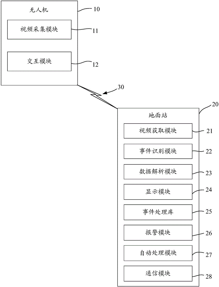
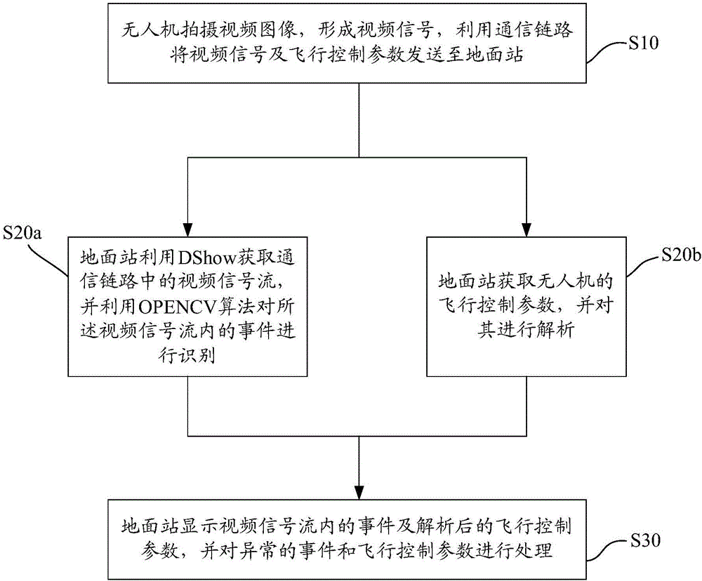
The invention provides a ground station fusion system and a ground station video data fusion method. The ground station fusion system comprises an unmanned aerial vehicle and a ground station; the unmanned aerial vehicle is connected with the ground station through a communication link; the unmanned aerial vehicle comprises a video capturing module which is used for shooting a video image, and transmitting the video image to the ground station through the communication link in the form of a video signal; the ground station comprises a video acquisition module, an event identification module, a data analysis module, a display module and an event processing library; the video acquisition module is used for acquiring a video signal flow in the communication link by utilizing DShow; the event identification module is used for identifying events in the video signal flow by utilizing the OPENCV algorithm; the data analysis module is used for acquiring and analyzing control parameters of the unmanned aerial vehicle; the display module is used for displaying the events in the video signal flow and the analyzed flight control parameters together; the event processing library is used for processing an identified abnormal event and an analyzed abnormal parameter; the time difference of switching independent images is eliminated; the ground station fusion system and the ground station video data fusion method are conductive to assisting in controlling the unmanned aerial vehicle, and are more efficient and convenient; the user experience is improved.

Description

technical field [0001] The invention relates to the technical field of unmanned aerial vehicles, in particular to a ground station fusion system and a ground station video data fusion method. Background technique [0002] In recent years, the drone industry has developed rapidly, and the application fields of drones have become more and more extensive. The UAV ground station is the command and control center of the entire UAV system, because most UAVs fly beyond the visual range, so the ground station is particularly important for UAVs. A complete ground station system can well assist ground station operators to monitor and control the flight status of the UAV in real time. However, the current ground station system has uneven technologies and cannot integrate all functions well. Most ground stations display video images and UAV control systems separately, relying on human eyes to identify relevant color data parameters, time-sensitive The performance is poor, and in terms...

Claims


Application Information

Patent Timeline
Patent Type & Authority Applications(China)
IPC IPC(8): G05D1/12
CPCG05D1/12
Inventor 金良黄长鑫赵久山
Owner SHENZHEN SMART DRONE UAV CO LTD
Why Eureka
Try Eureka