Method for drawing water system network graph in regional water conservancy planning

A network diagram and water system technology, applied in the field of drawing, can solve problems such as lack of intuition and unclear logical relationship, and achieve the effect of improving decision-making efficiency and level, simple processing method and high work efficiency.

Active Publication Date: 2017-01-04
淮安市水利勘测设计研究院有限公司
View PDF5 Cites 5 Cited by
  • Summary
  • Abstract
  • Description
  • Claims
  • Application Information

AI Technical Summary

Problems solved by technology

The current planning methods mainly present the planning results in the form of text, c...

Method used


Image

  • Method for drawing water system network graph in regional water conservancy planning
  • Method for drawing water system network graph in regional water conservancy planning
  • Method for drawing water system network graph in regional water conservancy planning

Examples


Embodiment

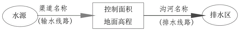
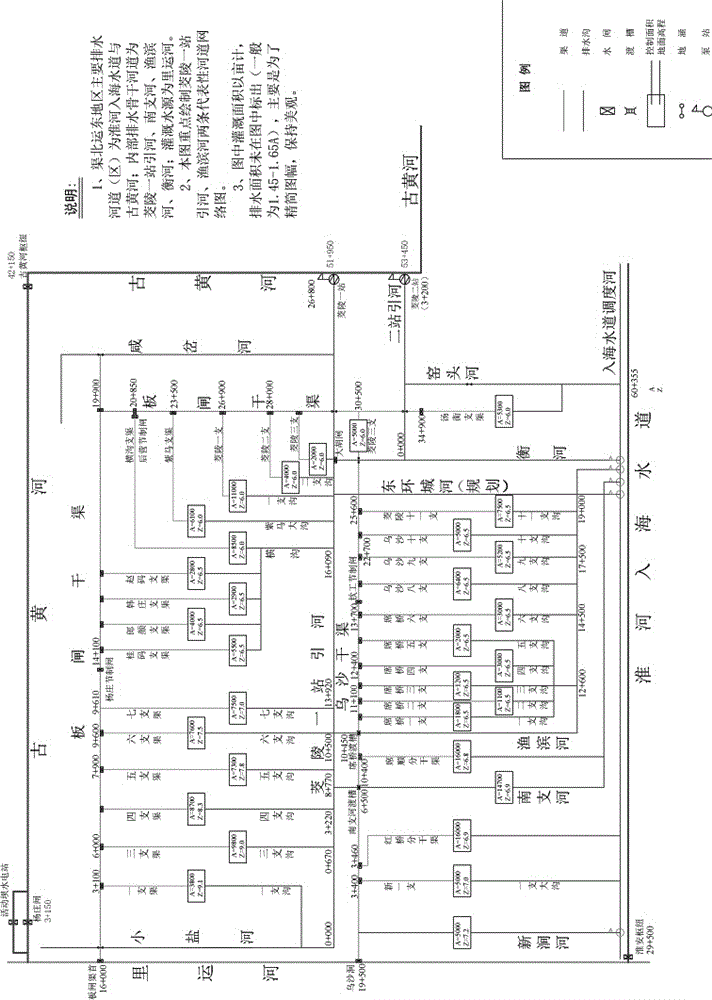
[0023] Embodiment: Draw the water system network diagram of the Yundong piece of water system connection project in Qubei District, Huai'an City according to the following steps

[0024] (1) In-depth field investigation and research to clarify the situation of the drainage system in each control area in the planning area;

[0025] (2) Determine the control area and average ground elevation of each branch canal and branch ditch, the branch number from the head of the branch canal to the water source, the branch number from the branch ditch to the drainage area, and the location of supporting buildings;

[0026] (3) Generalize and process the current water system map, and determine the drawing environment of the map frame, line type and font;

[0027] (4) Draw the water source, main canal head and supporting buildings along the line, drainage ditches, drainage areas and control buildings, and draw sub-main canals, branch canals and their corresponding irrigation areas, ditch riv...


PUM


Abstract

The invention discloses a method for drawing a water system network graph in regional water conservancy planning. The method for drawing a water system network graph comprises the steps of: performing early survey and data analysis, and generalizing current network graphs; inputting parameters, performing analytical calculation, and outputting a planned network graph; and performing rationality analysis and optimization adjustment, thus obtaining the water system network graph. The water system network graph is composed of nodes, connecting lines and graphic examples, wherein the nodes express sites of afflux, outflow, shunt and inflow of water flow; the connecting lines are venations; line segments and arrows express the trends of river and channel water delivery facilities; the graphic examples express reservoirs, lakes, pump stations and sluice project facilities; and the whole graph is like a network. The water system network graph provides intuitive and vivid illustration for water conservancy planning, and is strong in simulation performance and definite in logic relation.

Description

technical field [0001] The invention relates to a drawing method, in particular to a method for drawing a water system network diagram in regional water conservancy planning. Background technique [0002] The planning and layout of irrigation and drainage system is the foundation and core of regional water conservancy planning. The current planning methods mainly present the planning results in the form of text, charts, etc., which are not intuitive enough and the logical relationship is not clear enough. Contents of the invention [0003] The purpose of the present invention is to: design a water system network map drawing method in regional water conservancy planning, obtain a water system network map according to the drawing method, integrate geography, hydrology, water system, and engineering elements into one map, and provide intuitive and vivid images for water conservancy planning Graphical analysis, strong simulation performance, clear logical relationship. [00...

Claims


Application Information

Patent Timeline
IPC IPC(8): G06F17/50
CPCG06F30/18
Inventor 吴昌新王道虎黄苏宁周凤扬朱智兵徐永波王锦工曾庆祝顾正南谢亚军王鑫包钢皇甫全欢吴兵洪伟刘伟
Owner 淮安市水利勘测设计研究院有限公司
Why Eureka
Try Eureka