Three-dimensional image obtaining method based on small unmanned aerial vehicle video recording in engineering geological survey

A small unmanned aerial vehicle, three-dimensional image technology, applied in image communication, control of finding targets, components of color TVs, etc. Non-uniformity and other problems, to reduce the difficulty of splicing, improve the success rate, and achieve the same effect as the effective frame

Active Publication Date: 2017-01-11
长江三峡勘测研究院有限公司(武汉)
View PDF5 Cites 13 Cited by
  • Summary
  • Abstract
  • Description
  • Claims
  • Application Information

AI Technical Summary

Problems solved by technology

Traditional methods face problems such as difficulty in ensuring 70% coincidence of adjacent photos and uneven photo frames in field operations (such as figure 1 ), thus reducing the success rate of 3D image synthesis, resulting in the difficulty of on-site aerial photography and the low efficiency of obtaining 3D images

Method used


Image

  • Three-dimensional image obtaining method based on small unmanned aerial vehicle video recording in engineering geological survey
  • Three-dimensional image obtaining method based on small unmanned aerial vehicle video recording in engineering geological survey
  • Three-dimensional image obtaining method based on small unmanned aerial vehicle video recording in engineering geological survey

Examples


Embodiment Construction

[0038] In order to make the object, technical solution and advantages of the present invention more clear, the present invention will be further described in detail below in conjunction with the examples.

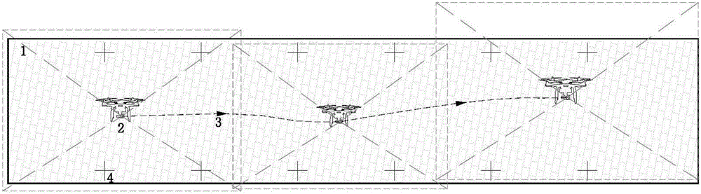
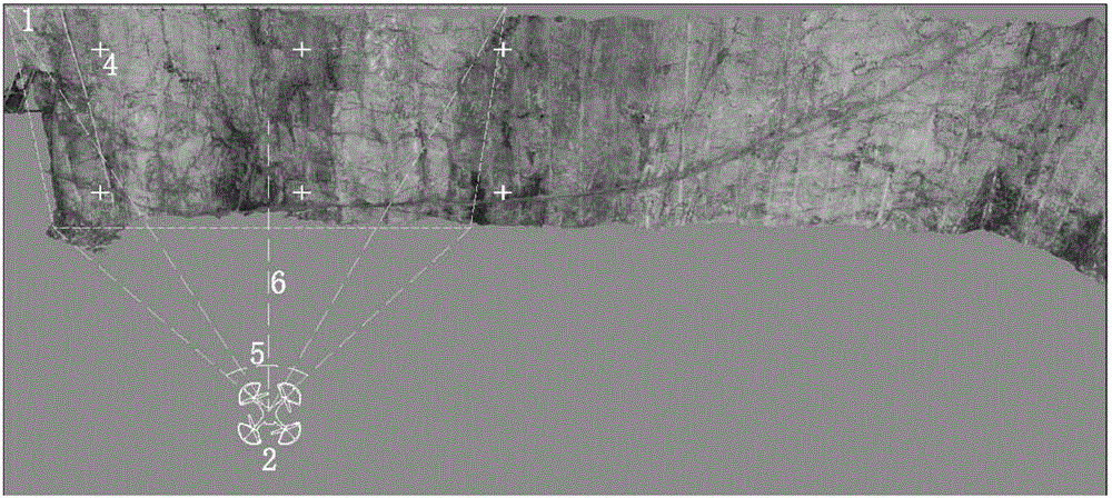
[0039] The dam slope of a water conservancy and hydropower project in southwest China has a height difference of 270m, and the single pre-splitting excavation height of the slope is 5m. The engineering geology is recorded using 3D image visualization. Taking the slope section of the dam abutment project with pile number 0-40~0-95 and elevation 878m~872m as an example, the description is as follows.

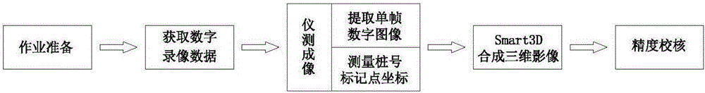
[0040] Such as figure 2 Shown, Step 1: Homework Preparation

[0041] (1) Preparation of special equipment: ① UAV and high-definition pan-tilt camera 1 set (affecting sensor 1 / 2.3 inch CMOS, effective pixel 12.4 million, such as DJI Phantom 3 Professional), ② Prism-free total station (such as Topcon ( GPT-3005LN) 1 set, measuring accuracy ±(10mm+10ppm), ③One 50m tape measure....


PUM


Abstract

The invention discloses a method for obtaining three-dimensional images based on small unmanned aerial vehicle video recording. According to the method, video recording is carried out on a target area by a high-definition camera built in a small unmanned aerial vehicle in a flying process; the images are extracted from the obtained video recording data according to a set fixed time interval; an overlap ratio among the images is ensured; and the extracted images are synthesized by employing Smart3D software, thereby obtaining the three-dimensional images of the target area. Compared with a conventional method of synthesizing the three-dimensional images by photographing the images, the method has the advantages that a success rate is higher and the problem that according to the conventional method, aerial photographing needs to be carried out again due to the fact the three-dimensional images are synthesized unsuccessfully can be avoided.

Description

technical field [0001] The invention relates to the technical field of engineering geological survey, in particular to a three-dimensional image acquisition method based on video recording of a small unmanned aerial vehicle in engineering geological survey. Background technique [0002] With the rapid development of small UAV technology, it is more and more widely used in the civilian field. UAVs have the characteristics of low cost, no risk of casualties, over-the-horizon flight, simple control, and high work efficiency. They are currently widely used in engineering construction, especially in engineering geological surveys, providing important technical support. [0003] As the development and construction of Southwest my country enters a peak period, in the vast alpine and valley areas of Southwest China, engineering construction is faced with a large number of high slope problems with complex geological conditions. High slope problems not only make engineering constructi...

Claims


Application Information

Patent Timeline
Patent Type & Authority Applications(China)
IPC IPC(8): H04N13/02G05D1/12H04N5/232
CPCG05D1/12H04N23/69
Inventor 王吉亮张熊杨静陈又华黄孝泉白伟周质荣宋涛曾立刘冲平郝喜明施炎
Owner 长江三峡勘测研究院有限公司(武汉)
Why Eureka
Try Eureka