Method, device and system for acquiring and sharing aircraft restricted area information

A technology of regional information and acquisition method, applied in three-dimensional position/channel control and other directions, can solve problems such as discrepancies in actual conditions and unreasonable flight route settings, and achieve the effect of ensuring real-time and accuracy

Active Publication Date: 2017-02-01
SHENZHEN AUTEL INTELLIGENT AVIATION TECH CO LTD
View PDF7 Cites 18 Cited by
  • Summary
  • Abstract
  • Description
  • Claims
  • Application Information

AI Technical Summary

Problems solved by technology

[0004] For this reason, the technical problem to be solved by the present invention is that in the prior art, aircraft players obtain various flight-restricted area information related to the aircraft according to the areas marked in advance on the map, which may be inconsistent with the actual situation, resulting in flight routes Unreasonable settings

Method used


Image

  • Method, device and system for acquiring and sharing aircraft restricted area information
  • Method, device and system for acquiring and sharing aircraft restricted area information
  • Method, device and system for acquiring and sharing aircraft restricted area information

Examples


Embodiment 1

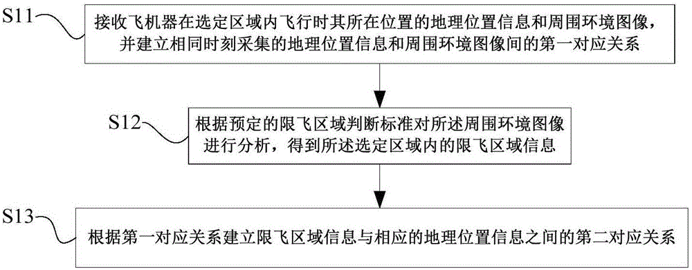
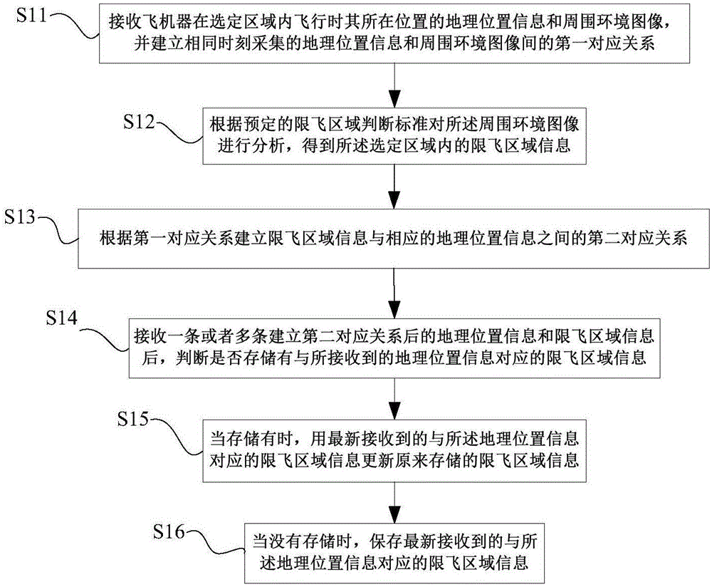
[0055] This embodiment provides a method for obtaining the information of the flight-restricted area of ​​the aircraft, such as figure 1 , figure 2 shown, including:

[0056] S11. Receive geographic location information and surrounding environment images of the location of the aircraft when flying in the selected area, and establish a first correspondence between the geographic location information and the surrounding environment images collected at the same time.

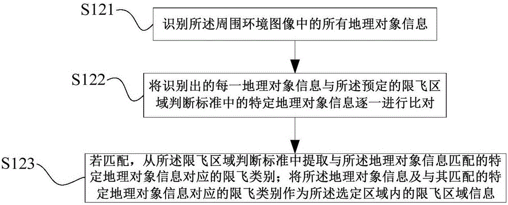
[0057] S12. Analyzing the surrounding environment image according to a predetermined criterion for judging the restricted-flying region, to obtain information about the restricted-flying region in the selected region.

[0058] S13. Establish a second correspondence between the fly-restricted area information and corresponding geographic location information according to the first correspondence.

[0059] S14. After receiving one or more pieces of geographic location information and flight-restricted area informa...

Embodiment 2

[0074] This implementation provides a method for sharing information on aircraft restricted areas, such as Figure 4 shown, including:

[0075] S21. Acquire the second correspondence between the restricted-fly area information and the corresponding geographic location information according to the acquisition method in Embodiment 1.

[0076] S22. Determine whether a sharing request is received.

[0077] S23. If yes, confirm the geographic location information corresponding to the sending area of ​​the sharing request.

[0078] S24. Query and feed back the flight-restricted area information corresponding to the geographic location information.

[0079] Specifically, the sharing request can be performed by an APP built in the smart phone, and steps S21-S24 can be performed by a server.

[0080] The method for sharing the flight-restricted area information of the aircraft described in this embodiment collects the correspondence between multiple pieces of restricted-fly area inf...

Embodiment 3

[0082] This embodiment provides a device for obtaining information on restricted flight areas of aircraft, which is applied to user terminals or server ends, such as Figure 5 As shown, can include:

[0083] The acquisition unit 11 is configured to receive the geographical position information and the surrounding environment image of the position where the aircraft is flying in the selected area, and establish a first correspondence between the geographical position information and the surrounding environment image collected at the same time relation.

[0084]The analysis unit 12 is configured to analyze the surrounding environment image according to a predetermined criterion for judging the restricted-flying region, and obtain information about the restricted-flying region in the selected region.

[0085] The associating unit 13 is configured to establish a second correspondence between the restricted-fly area information and corresponding geographic location information acc...


PUM


Abstract

The invention provides a method, a device and a system for acquiring and sharing aircraft restricted area information. The acquiring method is characterized by comprising steps: the geographical position information of the aircraft flying in a selected area and a surrounding environment image are received firstly, and a first corresponding relation between the geographical position information and the surrounding environment image which are acquired at the same moment is built; the surrounding environment image is analyzed according to a predetermined restricted area judgment standard, and the restricted area information in the selected area is obtained; and a second corresponding relation between the restricted area information and the corresponding geographical position information is built according to the first corresponding relation. According to the method, the device and the system for acquiring and sharing the aircraft restricted area information, the safe flight path of the aircraft can be acquired in real time, a restricted area is avoided, the restricted area information is shared, and a reliable basis is provided for setting an accurate flight path for the aircraft user.

Description

technical field [0001] The present invention relates to the technical field of aircraft, in particular to a method, device and system for acquiring and sharing information of restricted flight areas of aircraft. Background technique [0002] Aircraft such as unmanned aircraft are referred to as "UAV" for short, and "UAV" for English abbreviation. It first appeared in the 1920s, when it was used as a target drone for training. [0003] The human dream of flying has never stopped. Although drones have existed for a long time, they were basically used in military and commercial fields before. With the popularity of smart phones, people combine smart phones with drone technology It turns UAVs into consumer-grade UAVs (mobile phone remote control toys), which can realize various application forms such as aerial photography and virtual reality games, and the product types are gradually enriched, making consumer-grade UAVs more and more into the player's field of vision. However...

Claims


Application Information

Patent Timeline
Patent Type & Authority Applications(China)
IPC IPC(8): G05D1/10
Inventor 冯银华
Owner SHENZHEN AUTEL INTELLIGENT AVIATION TECH CO LTD
Why Eureka
Try Eureka