Enterprise geographic information display method based on asynchronous loading

An asynchronous loading, geographic information technology, applied in geographic information database, digital data processing, special data processing applications, etc., can solve the problem of unintuitive display method, inapplicability, increase user operation steps, etc., to avoid screen freezes , improve efficiency, display the effect of improving the effect

Inactive Publication Date: 2017-03-01
成都数联铭品科技有限公司
View PDF6 Cites 5 Cited by
  • Summary
  • Abstract
  • Description
  • Claims
  • Application Information

AI Technical Summary

Problems solved by technology

However, this display method requires the user to click on the target to display the detailed information, which increases the user's operation steps, and the display method is not intuitive enough, and it has a better display effect only on the premise that there is no need to intuitively display the detailed information of the data at one time
When it is necessary to display a large amount of information based on geographic location on the map tool at one time, including image information, the existing technical solutions cannot be applied

Method used


Image

  • Enterprise geographic information display method based on asynchronous loading
  • Enterprise geographic information display method based on asynchronous loading

Examples


Embodiment 1

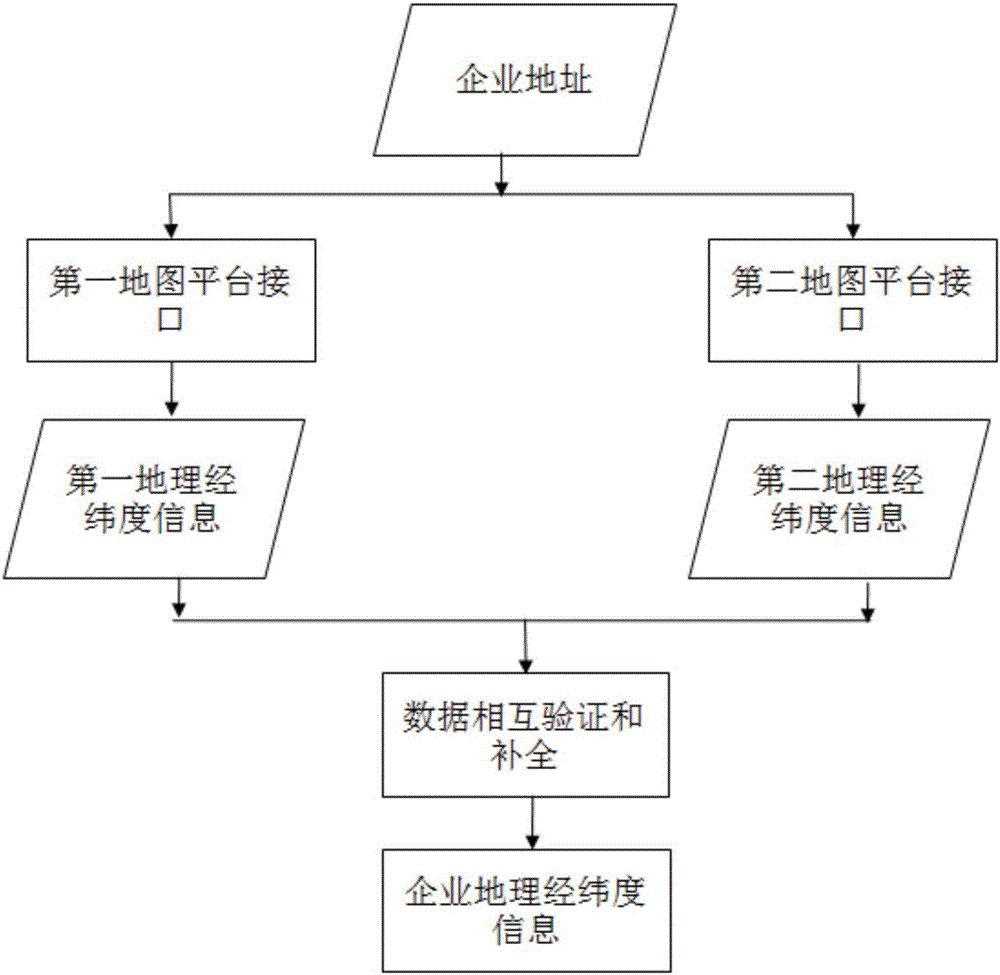
[0042] Such as figure 2 As shown, the company name and corresponding address information and picture information are crawled from the network according to the field settings. For example, the name is Chengdu ABCD Technology Co., Ltd., and the address is: No. xx, the middle section of Tianfu Avenue, Chengdu. Call the first map according to the address information The geographic latitude and longitude information corresponding to the enterprise address obtained by the platform interface is:

[0043] {"status": 0, "result": {"location": {"lng": 105.07392899855, "lat": 36.555138880016}, "precise": 1, "confidence": 80, "level": "\u5546\ u52a1\u5927\u53a6″}} From the returned information, it can be obtained that the credibility is: 80, the longitude is 105.07392899855, and the latitude is 36.555138880016.

[0044] The geographic latitude and longitude information corresponding to the enterprise address obtained by calling the second map platform interface is: {"status": "1", "info...


PUM


Abstract

The invention relates to the field of Internet information processing, in particular to an enterprise geographic information display method based on asynchronous loading. When a user enters a target enterprise map information display page, default map information is displayed, and then geographic coordinate information, text information and picture information of a target enterprise are read through a thread; the position of the enterprise and text and picture description corresponding to the enterprise are drawn on a displayed basic map page according to coordinates of the target enterprise. The problems that during synchronous display, the memory occupancy rate is too high, page refreshing efficiency is low and images slack are solved. Smoothness of image switching is guaranteed, and user experience is improved. The enterprise serves as an analysis object, display of the geographic information of the enterprise is achieved on a client, and technical support is provided for geographic region analysis of related enterprises, business analysis of related regions and the like.

Description

technical field [0001] The invention relates to the field of Internet information processing, in particular to a method for displaying enterprise geographic information based on asynchronous loading. Background technique [0002] With the social progress represented by the development of information technology, the accumulation of data and information has grown exponentially. The development of network technology has promoted the dissemination and accumulation of information. Network information data covers society, economy, politics, industries, enterprises, organizations, individuals In all aspects of activities, the large amount of data and low value density are the problems that plague the mining and utilization of such massive data information. In the massive data, how to accurately obtain the information that people care about has become an urgent problem to be solved. In the face of huge market demand, the Internet Search and big data analysis have become popular in t...

Claims


Application Information

Patent Timeline
IPC IPC(8): G06F17/30
CPCG06F16/9537G06F16/29G06F16/9574
Inventor 谢懿盛云范从俊
Owner 成都数联铭品科技有限公司
Why Eureka
Try Eureka