
Geological structural plane attitude measurement method

A technology of geological structure and measurement method, applied in the direction of measurement device, measurement angle, mapping and navigation, etc., can solve the problems of expensive, bulky equipment, and large interference by mineral magnetism, and achieve the effect of overcoming errors and improving efficiency.

Inactive Publication Date: 2017-04-26
YELLOW RIVER ENG CONSULTING
View PDF7 Cites 16 Cited by
  • Summary
  • Abstract
  • Description
  • Claims
  • Application Information

AI Technical Summary

Problems solved by technology

[0003] The traditional occurrence measurement of geological structural planes uses a mechanical geological compass. The traditional geological compass measurement method is contact measurement, which is greatly disturbed by mineral magnetism. For geological structural planes under complex conditions, such as cliffs, river blocks, It is difficult for surveyors to directly contact the roof of the high-altitude structure of the mine. The method of virtual extension of the structural surface is seriously affected by the measurement distance factor, and it is difficult to avoid a large deviation between the measured value and the objective true value.
[0004] In order to overcome the limitation of contact measurement with mechanical geological compass, William C.Haneberg established a three-dimensional model of rock slope by using digital close-range photogrammetry technology and carried out geological structural surface mapping work. Liu Zixia carried out digital close-range photogrammetry based Research on the application of rapid acquisition of rock mass structural plane information. Zhang Wen proposed a rock mass structural information processing method based on 3D laser scanning technology and carried out engineering applications. S.Slob studied the measurement of rock mass structural plane based on 3D laser scanning technology. Berger et al. used the SPOT satellite stereo image to extract the occurrence of surface formations. Liu Huaguo et al. carried out research on the extraction of near-surface formations using remote sensing image technology. Wang Biao applied GPS technology to near-surface formations. In the accurate measurement of horizontal formation occurrence, these technologies have greatly improved the measurement accuracy and speed, but the operation process of the instrument is complicated, or the equipment is bulky or expensive, and it is difficult to apply it on a large scale
Ma Qingxun invented a geological compass based on the principle of laser linear transmission, but the compass is still contact-type, and it is difficult to avoid the interference of mineral magnetism, and the special occurrence structure plane is not considered

Method used


Image

  • Geological structural plane attitude measurement method
  • Geological structural plane attitude measurement method
  • Geological structural plane attitude measurement method

Examples


Embodiment Construction

[0055] The embodiments of the present invention will be described in detail below in conjunction with the accompanying drawings. This embodiment is implemented on the premise of the technical solution of the present invention, and detailed implementation methods and specific operating procedures are provided, but the scope of protection of the present invention is not limited to the following Described embodiment.

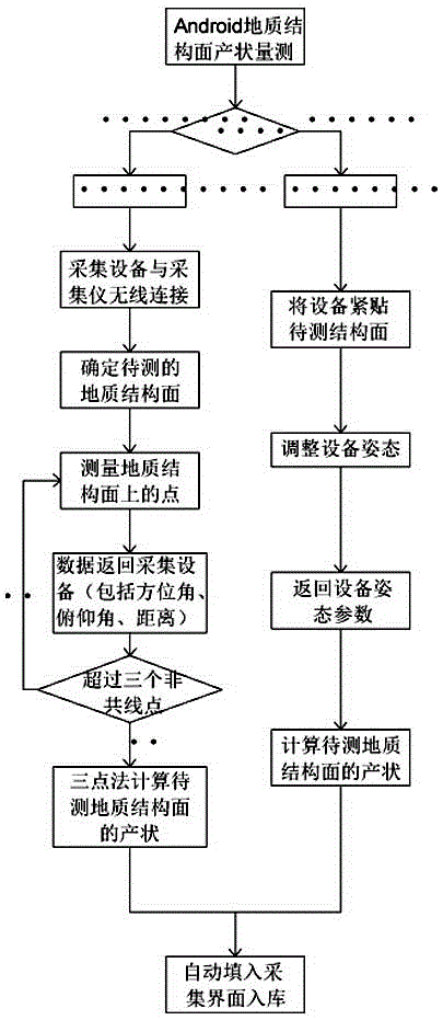
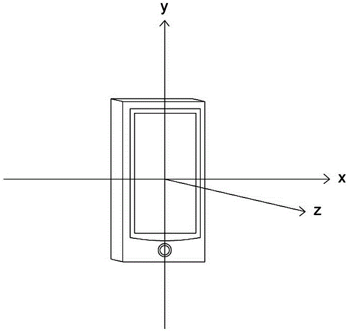
[0056] Such as figure 1 , 2As shown, the occurrence measurement method of the geological structural surface of the present invention selects a non-contact measurement method and a contact-type handheld Android acquisition device measurement method according to field conditions; the contact-type handheld Android acquisition device includes a mobile phone, a tablet computer ,

[0057] The non-contact measurement method is carried out according to the following steps:

[0058] The first step is to select the location of the station according to the situation of the...


PUM


Abstract

The invention discloses a geological structural plane attitude measurement method; according to on-site conditions, a non-contact type measurement method and a contact type handheld Android acquisition device measurement method are selected. The non-contact type measurement method comprises the following steps: one, according to measurement on-site conditions, selecting a measurement station relocation site; two, placing a range finder at the measurement station site; three, carrying out wireless transmission connection of an acquisition device and the range finder; four, starting an attitude measurement interface of the acquisition device, rotating the range finder to make a measurement beam shoot to three non-collinear points of a structural plane, and sending the measurement data to the acquisition device through a wireless transmission way; and five, calculating the attitude of the geological structural plane, wherein the attitude comprises a moving direction gamma, a tendency beta, and a dip angle alpha. The method has the advantages that limit of a traditional compass contact type measurement method is broken through, and the attitude measurement is performed on a long-distance or difficult-to-contact structural plane; the errors of attitude measurement brought by mineral magnetism are effectively overcome, and the efficiency is improved.

Description

technical field [0001] The invention relates to a geological survey and measurement method, in particular to a method for measuring the occurrence of a geological structure plane. Background technique [0002] The occurrence of geological structural plane includes three elements: strike, dip and dip. The strike is the extension direction of the intersection line between the geological object layer and the horizontal plane. The dip is the direction of the projection of the inclined line on the horizontal plane on the surface of the geological object. The inclination is the angle between the inclined line and the horizontal plane. [0003] The traditional occurrence measurement of geological structural planes uses a mechanical geological compass. The traditional geological compass measurement method is contact measurement, which is greatly disturbed by mineral magnetism. For geological structural planes under complex conditions, such as cliffs, river blocks, The high-altitu...

Claims


Application Information

Patent Timeline
Patent Type & Authority Applications(China)
IPC IPC(8): G01C1/00
CPCG01C1/00
Inventor 侯清波刘灏裴丽娜李清波刘振红齐菊梅王学潮温秋生罗延婷王耀邦娄国川王耀军闫思泉
Owner YELLOW RIVER ENG CONSULTING
Learn More