Method for automatically extracting paddy rice growing region based on MODIS

A technology of automatic extraction and planting area, applied in the direction of instruments, character and pattern recognition, computer parts, etc., can solve problems such as limiting the scope of research, and achieve the effect of changing trend assessment

Inactive Publication Date: 2017-04-26
NANJING INST OF GEOGRAPHY & LIMNOLOGY
View PDF3 Cites 21 Cited by
  • Summary
  • Abstract
  • Description
  • Claims
  • Application Information

AI Technical Summary

Problems solved by technology

However, most of the current technical means are aimed at a specific research area within a certain range. It is usually ass

Method used


Image

  • Method for automatically extracting paddy rice growing region based on MODIS
  • Method for automatically extracting paddy rice growing region based on MODIS
  • Method for automatically extracting paddy rice growing region based on MODIS

Examples


Embodiment Construction

[0057] The technical solution of the present invention is described in further detail below through specific examples, but it is necessary to point out that the following experiments are only used to describe the content of the invention, and do not constitute limitations to the protection scope of the present invention.

[0058] The present invention gives MODIS sensor MOD09A1 data to realize the extraction of rice area in Jiangxi Province in 2010, and the steps are as follows:

[0059] 1. Preprocessing of MOD09A1 data;

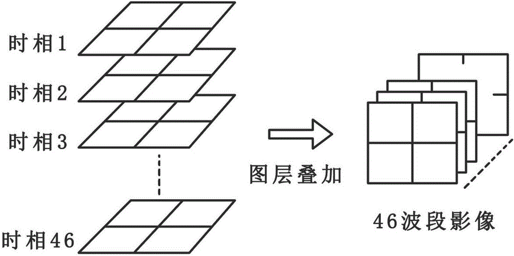
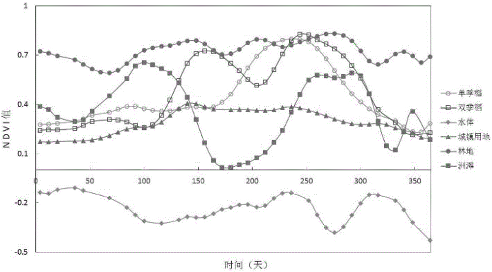
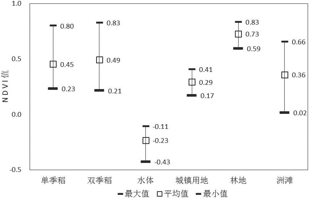
[0060] Remote sensing index calculation and index image time series synthesis: calculation of NDVI and LSWI at each time phase 2 Index, its calculation formula is as follows:

[0061]

[0062]

[0063] where ρ nir is the reflectivity in the near-infrared band, ρ red is the red band reflectance, ρ swir2 It is the reflectivity of MODIS second short-wave infrared band (band: 2105-2155nm).

[0064] Cloud mask: The pixels with blue band reflectivity gr...


PUM


Abstract

The invention discloses a method for automatically extracting a paddy rice growing region based on a MODIS. The method is characterized by subjecting MODIS data to preprocessing such as index calculation, cloud mask, time series synthesis and the filtering; eliminating different types of typical ground features by using a threshold value method based on a normalized difference vegetation index; detecting a normalized difference vegetation index curve of a pixel element by using an extremum detection method to find out pixel elements likely to be the paddy rice, and performing paddy rice heading stage inversion; and finally extracting the paddy rice pixel elements by using a relationship between a land surface water index and the normalized difference vegetation index during a paddy rice transplanting period. The method can extract the paddy rice pixel elements accurately, has strong applicability in different regions, and can distinguish single-cropping rice and multi-cropping rice, and can provide fast and accurate paddy rice spatial distribution for land, mapping, and agriculture departments, and provides support for the scientific decision of different departments.

Description

technical field [0001] The invention relates to a method for automatically extracting rice planting areas based on a MODIS sensor. Background technique [0002] Rice is the second largest food crop in my country and is related to national food security issues. The investigation of rice area and spatial distribution has always been the focus of land and resources investigation (Peng et al.2014; Zhang et al.2015; Deng Rui et al.2010). In recent years, with the development of satellite platform technology, the use of remote sensing to conduct large-scale surveys of land resources has become a technical hotspot, and the use of multi-temporal remote sensing for automatic extraction of rice is one of them. In actual use, the MODIS (Moderate-resolution Imaging spectroradiometer) sensor mounted on the Terra / Auqa satellite has the characteristics of multi-band (36 bands), high time phase (1 day), and medium spatial resolution (250-1000m). is widely used. [0003] Rice is an annual ...

Claims


Application Information

Patent Timeline
IPC IPC(8): G06K9/00G06K9/46
CPCG06V20/188G06V10/443
Inventor 何隆华姚飞
Owner NANJING INST OF GEOGRAPHY & LIMNOLOGY
Why Eureka
Try Eureka