
A GPS position time series noise model building method
A time series and noise model technology, applied in the field of satellite navigation, can solve the problem of not simply selecting the optimal noise model of the model with a larger MLE value, etc.
- Summary
- Abstract
- Description
- Claims
- Application Information
AI Technical Summary
Problems solved by technology
Method used
Image

Examples
Embodiment Construction
[0027] In order to make the purpose, technical solutions and beneficial effects of the present invention more clear, the present invention will be further described below in conjunction with the accompanying drawings and specific implementation methods. It should be understood that the collective embodiments described below are only used to explain the present invention, not to limit the present invention.
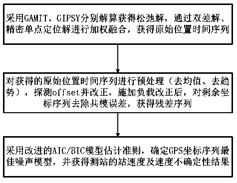
[0028] please see figure 1 A method for establishing a GPS position time series noise model provided by the invention comprises the following steps:
[0029] Step 1: For GPS observations and related files (ephemeris files, table files, etc.), use a variety of calculation algorithms to solve, obtain the single-day relaxation solutions of GPS stations respectively, and use different solution weights for joint solutions through public base stations Calculate and obtain the GPS station coordinate position time series;
[0030] To obtain the GPS station coordinate position ti...
PUM
 Abstract
Description
Claims
Application Information