The Digitization Method of 2D Equidistant Projection

A technique of equidistant and projected images, which is applied in image data processing, 2D image generation, instruments, etc., can solve the problems of difficulty in data acquisition, inconvenience of scientific research work, difficulty in obtaining original data, etc.

Inactive Publication Date: 2019-10-18
THE FIRST INST OF OCEANOGRAPHY SOA
View PDF4 Cites 0 Cited by
  • Summary
  • Abstract
  • Description
  • Claims
  • Application Information

AI Technical Summary

Problems solved by technology

Many types of marine data can be obtained directly through the Internet or other means, but at the same time, some data are only released in the form of images, and it is difficult to directly obtain original data, such as images retrieved by satellites with undisclosed algorithms, artificially drawn historical imagery etc.
Most of these images have very important research value, but because of the difficulty of data acquisition, it brings great inconvenience to scientific research. Therefore, it is necessary to develop a method for image digitization, especially for difficult two-dimensional images. extra important

Method used


Image

  • The Digitization Method of 2D Equidistant Projection
  • The Digitization Method of 2D Equidistant Projection
  • The Digitization Method of 2D Equidistant Projection

Examples


Embodiment Construction

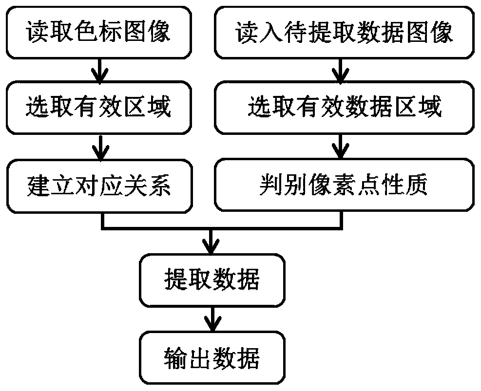
[0039] 1 Image Digitization Method

[0040] The procedure of this method is as follows figure 1 shown.

[0041] 1.1 Data introduction

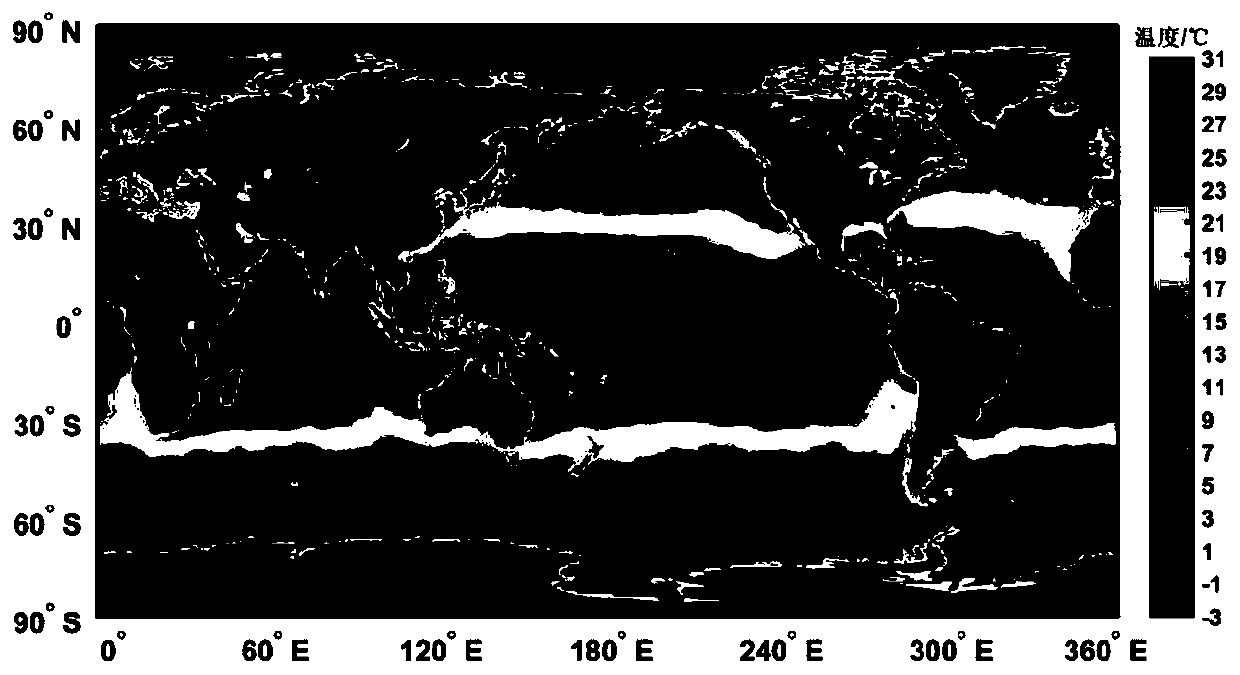
[0042] Levitus is the climatic ocean data produced by the Marine Climatology Laboratory of the National Oceanographic Data Center (NODC). It has three different time scales: annual average, seasonal average and monthly average, with a spatial resolution of 1°, a longitude range from 0.5°E to 0.5°W, a latitude range from 89.5°S to 89.5°N, and 33 vertical layers . Such as figure 2 is the monthly mean global sea surface temperature data for January.

[0043] 1.2 Method Introduction

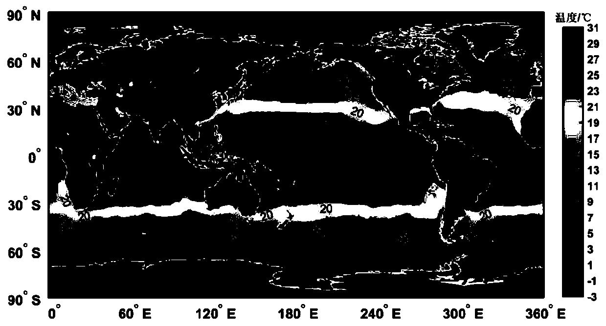
[0044] Read the image, you can directly get the RGB value of the image, but if you want to get the data value corresponding to each RGB value, you should determine the corresponding relationship between the RGB color value and the data value, usually these relationships are included in the content of the color scale. This part takes the global sea surface tem...


PUM


Abstract

The invention discloses a method for digitalizing a two-dimensional equally-spaced projection image. The method comprises five steps such as color code determination, processing for an image with the data to be extracted, data extraction, data extraction optimization and coordinate determination. By applying the method, a great amount data which is difficult to be acquired originally but has very high practical values can be acquired, and vast application space still exists according to different specialties. Therefore, implementation of the method has extremely great application values.

Description

technical field [0001] The invention relates to a digitization method of a two-dimensional equidistant projection map. Background technique [0002] In recent decades, ocean observation technology has developed rapidly, especially with the maturity of satellite technology, ocean data has increased greatly, which has greatly promoted the progress of research work. Many types of marine data can be obtained directly through the Internet or other means, but at the same time, some data are only released in the form of images, and it is difficult to directly obtain original data, such as images retrieved by satellites with undisclosed algorithms, artificially drawn historical images, etc. Most of these images have very important research value, but because of the difficulty of data acquisition, it brings great inconvenience to scientific research. Therefore, it is necessary to develop a method for image digitization, especially for difficult two-dimensional images. Extra importa...

Claims


Application Information

Patent Timeline
Patent Type & Authority Patents(China)
IPC IPC(8): G06T11/00
Inventor 郁诚成孙宝楠杨永增连展
Owner THE FIRST INST OF OCEANOGRAPHY SOA
Why Eureka
Try Eureka