Supercharge Your Innovation With Domain-Expert AI Agents!

A method for making a three-dimensional visualization remote sensing image surface classification model

A technology of remote sensing images and classification models, applied in image analysis, image enhancement, 3D modeling, etc., can solve problems such as inconvenience in describing two-dimensional information, trouble for people, and illusions

Active Publication Date: 2019-04-02
GEOVIS CO LTD
View PDF8 Cites 0 Cited by
  • Summary
  • Abstract
  • Description
  • Claims
  • Application Information

AI Technical Summary

Problems solved by technology

However, traditional remote sensing image maps often cause illusions in visual interpretation, especially people without remote sensing background knowledge often regard rivers as mountain ridges and mountain ridges as rivers, which cause great trouble to people when they are applied
Although the 3D remote sensing image with the digital elevation model (DEM) as the elevation has great advantages, it is very inconvenient to describe the 2D information.

Method used


Image

  • A method for making a three-dimensional visualization remote sensing image surface classification model
  • A method for making a three-dimensional visualization remote sensing image surface classification model
  • A method for making a three-dimensional visualization remote sensing image surface classification model

Examples


Embodiment Construction

[0027] In order to better understand the present invention, the method of the present invention will be further described below with reference to the description of the embodiments in conjunction with the accompanying drawings.

[0028] In the following detailed description, numerous specific details are set forth in order to provide a thorough understanding of the present invention. However, it will be understood by those skilled in the art that the present invention may be practiced without these specific details. In the embodiments, well-known methods, procedures, components have not been described in detail so as not to unnecessarily obscure the embodiments.

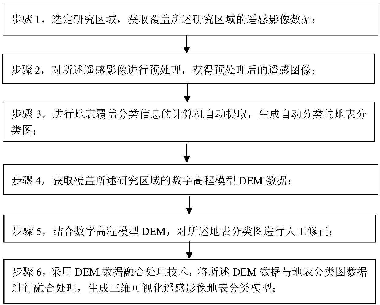
[0029] see figure 1 As shown, a method for making a three-dimensional visualization remote sensing image surface classification model of the present invention is characterized in that it includes the following steps:

[0030] Step 1, select a research area, and obtain remote sensing image data covering the research...


PUM


Abstract

A method for making a three-dimensional visual remote sensing image land surface classification model: selecting a research area, obtaining remote sensing image data covering the research area; performing preprocessing on the remote sensing image to obtain a preprocessed remote sensing image; performing land cover classification The computer automatically extracts the information to generate an automatically classified surface classification map; obtains the digital elevation model DEM data covering the research area; combines the digital elevation model DEM to manually correct the surface classification map; adopts DEM data fusion processing technology, The DEM data is fused with the surface classification map data to generate a three-dimensional visual remote sensing image surface classification model; the present invention combines the planar remote sensing image with the DEM, high-precision multi-source data fusion, and establishes a surface classification identification and interpretation expert With participation, based on accurate classification and recognition methods, a three-dimensional visual remote sensing image surface classification model was established to achieve fast and accurate classification and achieve three-dimensional visualization effects.

Description

technical field [0001] The technology is applicable to the field of geographic information system mapping, specifically a method for making a three-dimensional visualized remote sensing image surface classification model. Background technique [0002] With the implementation and development of a series of geographic information systems such as digital city, digital land, and digital earth, remote sensing images provide a new method for humans to understand the earth from multiple perspectives and scales with its rich information and intuitive expression. With new means, Landsat TM images have high spatial resolution, spectral resolution, extremely rich information and high positioning accuracy, which can meet the needs of agriculture, forestry, water, soil, geology, geography, surveying and mapping, regional planning, environmental Monitoring and other thematic analysis and compilation of 1:100,000 or larger scale thematic maps, and the requirements for repairing and measuri...

Claims


Application Information

Patent Timeline
Patent Type & Authority Patents(China)
IPC IPC(8): G06T17/05G06T7/11G06K9/62
CPCG06T17/05G06T2207/10032G06T2207/20221G06T2207/30184G06F18/24
Inventor 胡煜王一李宇光
Owner GEOVIS CO LTD
Features
  • R&D
  • Intellectual Property
  • Life Sciences
  • Materials
  • Tech Scout
  • Unparalleled Data Quality
  • Higher Quality Content
  • 60% Fewer Hallucinations
Learn More