Inertial navigation cooperative localization method and localization equipment

A collaborative positioning and equipment technology, applied in road network navigators, navigation through speed/acceleration measurement, etc., can solve the problems of inconsistent inertial navigation positions and insufficient positioning accuracy.

Active Publication Date: 2017-06-23
HUAWEI TECH CO LTD
View PDF6 Cites 1 Cited by
  • Summary
  • Abstract
  • Description
  • Claims
  • Application Information

AI Technical Summary

Problems solved by technology

[0004] However, when a business requires high positioning accuracy and the inertial navigation error of device B cannot meet the business requirements, the posit...

Method used


Image

  • Inertial navigation cooperative localization method and localization equipment
  • Inertial navigation cooperative localization method and localization equipment
  • Inertial navigation cooperative localization method and localization equipment

Examples


Embodiment Construction

[0070] For ease of understanding, the following first introduces the inertial navigation equipment and the basic calculation method of inertial navigation positioning in this application:

[0071] Inertial navigation equipment refers to mobile equipment with inertial navigation components that can realize inertial navigation positioning.

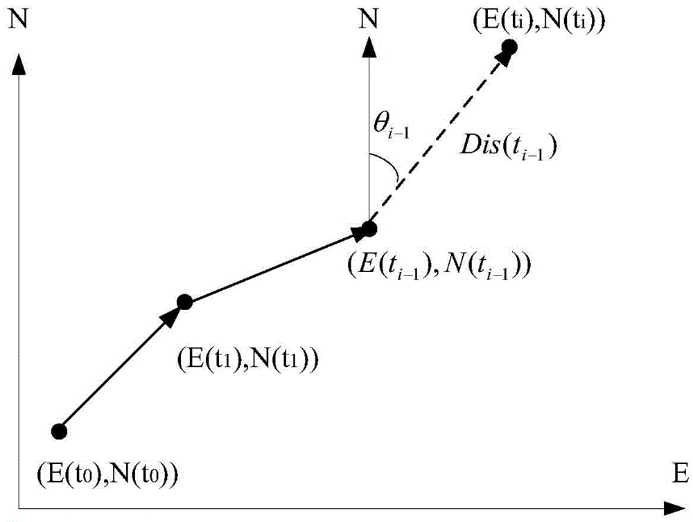
[0072] The basic calculation method of inertial navigation positioning is human dead reckoning method, please refer to figure 2 :

[0073] Taking N as the true north direction, E as the true east direction, and θ as the direction angle of the pedestrian track (obtainable through the gyroscope), it is assumed that the initial position of the mobile device is (E(t0), N(t0)), and the pedestrian steps The step distance is Dis (the walking speed and walking time are obtained by integrating the accelerometer), then the inertial navigation position at time i can be obtained as (E(ti), N(ti)), and the calculation formula is as follows:

[0074] ...


PUM


Abstract

The invention discloses an inertial navigation cooperative localization method and localization equipment, which can improve localization precision. The method comprises the following steps of step 1, acquiring a first location parameter, a second location parameter and a distance vector from first equipment to second equipment; step 2, according to the current first location parameter, the current second location parameter and the distance vector, calculating a first target location parameter by a first preset algorithm, if a target inertial navigation error of the first equipment is not smaller than a preset error threshold, performing step 3, and if the target inertial navigation error of the first equipment is smaller than the preset error threshold, performing step 4; step 3, according to the first target location parameter, the current second location parameter and the distance vector, calculating a second target location parameter by a second preset algorithm, taking the first target location parameter as a new first location parameter, taking the second target location parameter as a new second location parameter, and performing the step 2; and step 4, outputting a target inertial navigation location of the first equipment.

Description

technical field [0001] The invention relates to the field of positioning, in particular to an inertial navigation cooperative positioning method and positioning equipment. Background technique [0002] Inertial Navigation System (INS for short) refers to the use of inertial components (accelerometers and gyroscopes) to measure the acceleration and navigation attitude angle of the equipment carrying the inertial components, and to obtain the speed and position of the equipment through integration and calculation for navigation. positioning technology. Inertial navigation systems are widely used in many navigation fields such as guided weapons, rockets, aircraft, ships and navigation. The application of inertial navigation system in the field of positioning can realize passive and autonomous positioning without relying on positioning signals or systems other than inertial components. However, inertial components will cause error accumulation during long-term operation, thereb...

Claims


Application Information

Patent Timeline
IPC IPC(8): G01C21/16
CPCG01C21/16G01C21/26
Inventor 余西西
Owner HUAWEI TECH CO LTD
Why Eureka
Try Eureka