A construction method of urban spatial holographic map based on multi-source big data fusion

A construction method and big data technology, applied in the construction and visualization of urban spatial holographic maps, can solve the problems of backward display field, lack of urban geospatial coordinates, and less attention to the interaction relationship of building spatial layout, so as to achieve rapid acquisition and intuitiveness. Query display, reduce manual repetitive labor, and facilitate the effect of data input and output

Active Publication Date: 2019-04-09
SOUTHEAST UNIV
View PDF5 Cites 2 Cited by
  • Summary
  • Abstract
  • Description
  • Claims
  • Application Information

AI Technical Summary

Problems solved by technology

[0004] At present, research on urban multi-source big data at home and abroad mainly focuses on data collection and visualization, which are mostly displayed in the form of charts and animations, and less attention is paid to the mutual influence between various urban data systems and large-scale urban spatial forms and architectural spatial layouts. , lacking the production and dynamic display technology of a holographic digital map system based on the full coverage of urban space
At present, in the production technology of urban spatial holographic maps, there is a lack of urban geographic spatial coordinates, data processing in a single dimension, and lagging behind in the field of urban spatial holographic map production and display of large-scale composite data

Method used


Image

  • A construction method of urban spatial holographic map based on multi-source big data fusion
  • A construction method of urban spatial holographic map based on multi-source big data fusion
  • A construction method of urban spatial holographic map based on multi-source big data fusion

Examples


Embodiment Construction

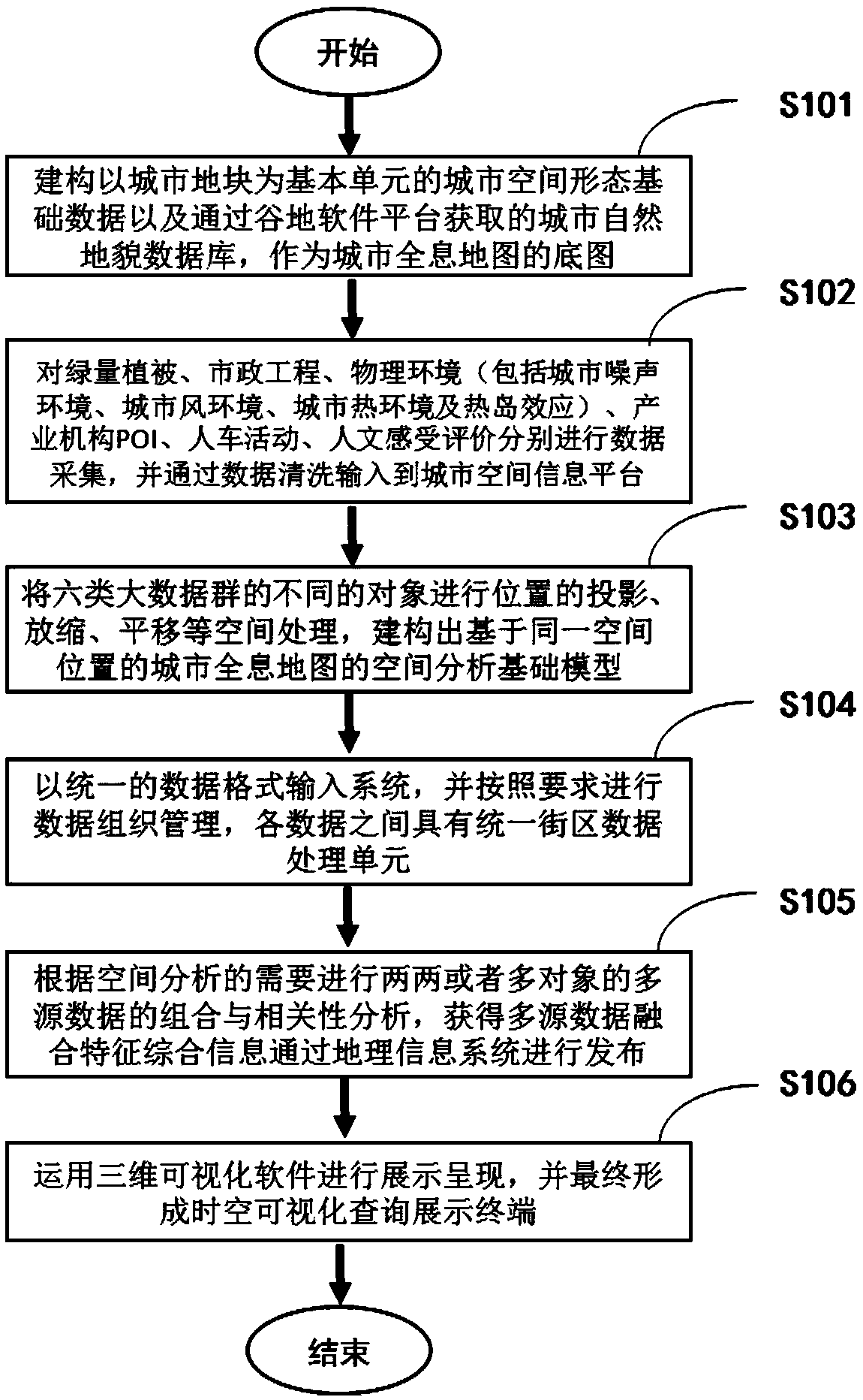
[0054] The present invention will be further described below in conjunction with the accompanying drawings.

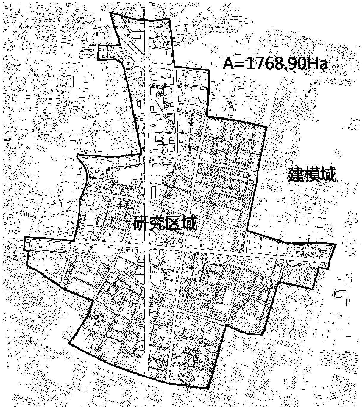
[0055] The following will combine Nanjing Xinjiekou central area (with an area of ​​about 5.7 square kilometers, a distance of about 3.9 kilometers between the north and south ends, and about 3.2 kilometers between the east and west ends. The construction of the urban space holographic map based on multi-source big data fusion and the visualization method case and accompanying drawings illustrate the technical solution of the present invention in detail (such as figure 2 ), the present invention comprises the steps of:

[0056] A. Through the detection of satellite remote sensing and UAV technology combined with the background data of openstreet map, the spatial elements of buildings, roads and blocks in the central area of ​​Xinjiekou were extracted and electronically vectorized, and the street view pictures of Baidu online map platform were used for real-time correc...


PUM


Abstract

The invention discloses a method for constructing a holographic map of urban space based on the fusion of multi-source big data. environment and heat island effect), POI of industrial organizations, human and vehicle activities, and evaluation of humanistic feelings are mapped to the cloud database through different layers, and combined with the urban spatial form, the spatial characteristics of different types of data can be intuitively and dynamically displayed and output, which can be used by various urban systems in real time Detection is beneficial to the practice of urban planning and design engineering. Based on the cloud data terminal, the present invention can cope with the processing of massive data and perform real-time fast query and display; by superimposing multi-source big data and urban spatial form data under the same digital map system, the multi-source based urban coordinate system can be realized The seamless collection of data interfaces and the simulated dynamic display of spatial characteristics.

Description

technical field [0001] The present invention relates to a construction and visualization technology of a holographic map of urban space, and more particularly to a construction method of a holographic map of urban space based on multi-source big data fusion. Background technique [0002] With the development of information technology, informatization and intelligence have become the mainstream of contemporary development, which leads to an extremely large amount of information generated in daily life, forming a holographic digital map of the city. Compared with traditional paper maps that only indicate streets, place names, and distances, holographic digital maps have the characteristics of positioning, visualization, and real-time monitoring. More importantly, the urban holographic digital map will carry out comprehensive and comprehensive information expression and analysis of various systems and units of the city from the surface to the depth, from the real to the virtual...

Claims


Application Information

Patent Timeline
Patent Type & Authority Patents(China)
IPC IPC(8): G06F16/29
CPCG06F16/29Y02A30/60
Inventor 杨俊宴熊伟婷
Owner SOUTHEAST UNIV
Why Eureka
Try Eureka