GPS-RTK-combined forest highway measurement system and measurement method

A GPS-RTK, measurement system technology, applied in the directions of radio wave measurement system, measurement device, satellite radio beacon positioning system, etc., can solve the problems of difficult measurement, low measurement accuracy, low measurement accuracy in forest areas, etc.

Inactive Publication Date: 2017-07-14
CCCC FIRST HARBOR ENG +1
View PDF8 Cites 17 Cited by
  • Summary
  • Abstract
  • Description
  • Claims
  • Application Information

AI Technical Summary

Problems solved by technology

[0004] The present invention provides a forest area road measurement system and measurement method based on GPS-RTK combination, which is used to solve the problem of low measurement accuracy and relatively low measurement accuracy of forest area road measurement system based on GPS-RTK combination in the prior art. Difficult and less accurate measurements

Method used


Image

  • GPS-RTK-combined forest highway measurement system and measurement method
  • GPS-RTK-combined forest highway measurement system and measurement method
  • GPS-RTK-combined forest highway measurement system and measurement method

Examples


Embodiment Construction

[0025] The following will clearly and completely describe the technical solutions in the embodiments of the present invention with reference to the accompanying drawings in the embodiments of the present invention. Obviously, the described embodiments are only some, not all, embodiments of the present invention. Based on the embodiments of the present invention, all other embodiments obtained by persons of ordinary skill in the art without making creative efforts belong to the protection scope of the present invention.

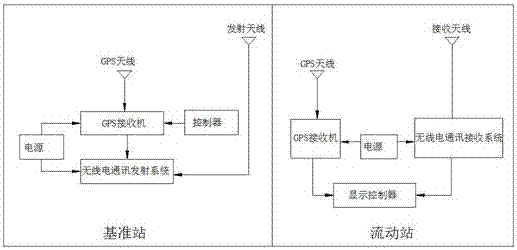
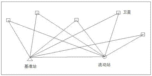
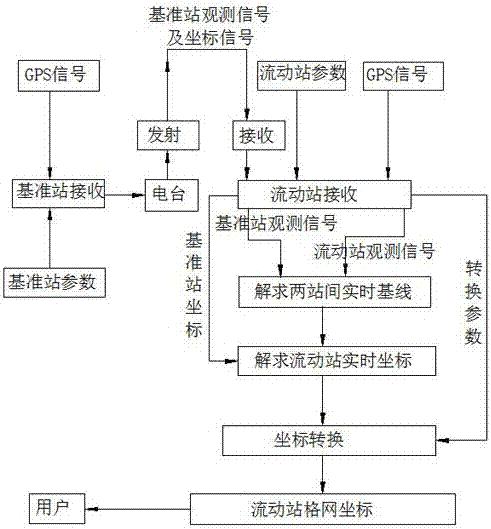
[0026] Such as Figure 1 to Figure 4 As shown, the embodiment of the present invention provides a kind of combined forest area road measurement system based on GPS-RTK, comprising: GPS-RTK system, GPS-RTK system is made up of base station, several rover stations and radio communication system three parts; The station includes GPS receiver, GPS antenna, transmitting antenna, radio communication transmitting system, power supply and controller; GPS receiver and ...


PUM


Abstract

The invention discloses a GPS-RTK-combined forest highway measurement system and a measurement method. The system of the invention includes a GPS-RTK system. The GPS-RTK system includes a base station, a plurality of mobile stations and a radio communication system. The base station includes a GPS receiver, a GPS antenna, a transmitting antenna, a radio communication transmission system, a power supply and a controller. The GPS receiver and the radio communication transmission system are electrically connected to the power supply, separately. The controller is electrically connected to the GPS receiver. Each mobile station includes a GPS receiver, a GPS antenna, a receiving antenna, a radio communication receiving system, a power supply and a display controller. For each mobile station, the GPS receiver and the radio communication receiving system are electrically connected to the power supply, separately, and the GPS receiver and the radio communication receiving system are electrically connected to the display controller, separately. The GPS-RTK-combined forest highway measurement system enables accurate measurement of forest highways and simple transmission and reception of measurement data.

Description

technical field [0001] The present invention relates to the technical field of forest area road measurement system, and more specifically relates to a forest area road measurement system and measurement method based on GPS-RTK combination. Background technique [0002] The measurement of forest areas has always been a difficult point in the field of measurement, and many problems often occur in the measurement of forest areas by measuring instruments. In the face of complex terrain, we are not helpless. Many applicable methods for forest area measurement and countermeasures for reducing the impact on forest canopy and mountains have been studied at home and abroad. However, many studies are limited to theoretical analysis and experimental subjects. It is difficult for general units to reach the technical level. How to make use of limited resources and improve the technology and management measures to do a good job in forest area measurement is the goal we want to achieve. ...

Claims


Application Information

Patent Timeline
Patent Type & Authority Applications(China)
IPC IPC(8): G01S19/43
CPCG01S19/43
Inventor 武建华李永明辛红芳杜景超王志国崔迎武娟
Owner CCCC FIRST HARBOR ENG
Why Eureka
Try Eureka