Method, device and system for quality judgment of geographic information library building charting data

A mapping data and geographic information technology, applied in the field of surveying and mapping, can solve the problems that the fairness of the judgment results cannot be guaranteed, the acquisition speed of the competition results is slow, and the work complexity of the referees is high, so as to reduce the work complexity and improve the judgment efficiency. , the effect of avoiding bias

Pending Publication Date: 2017-08-04
SICHUAN SURVEYING & MAPPING PROD QUALITY SUPERVISION & INSPECTION STATION OF THE MINIST OF NATURAL RESOURCES SICHUAN SURVEYING & MAPPING PROD QUALITY SUPERVISION & INSPECTION STATION
View PDF4 Cites 6 Cited by
  • Summary
  • Abstract
  • Description
  • Claims
  • Application Information

AI Technical Summary

Problems solved by technology

With the continuous enrichment of competition content, continuous improvement of quality, and continuous integration of new knowledge, new technology, and new skills, the traditional people-centered, simple grouping, single referee overall evaluation as the main working mode, production technology standards and The simple c

Method used


Image

  • Method, device and system for quality judgment of geographic information library building charting data
  • Method, device and system for quality judgment of geographic information library building charting data
  • Method, device and system for quality judgment of geographic information library building charting data

Examples


no. 1 example

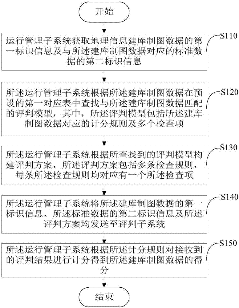
[0027] figure 2 A flow chart showing the quality evaluation method for geographic information database construction and mapping data provided by the first embodiment of the present invention, please refer to figure 2 , this embodiment describes the method flow of the quality evaluation of the geographical information database construction and mapping data executed in the operation management subsystem 100, and the method includes:

[0028] Step S110, the operation management subsystem acquires the first identification information of the geographic information database construction and mapping data and the second identification information of the standard data corresponding to the database construction and mapping data;

[0029] Wherein, the first identification information may be the storage address of the geographic information library building mapping data, and the second identification information may be the storage address of the standard data. For example, the geograph...

no. 2 example

[0056] Figure 4 Shows the flow chart of the method for evaluating the quality of geographic information database construction and mapping data provided by the second embodiment of the present invention, please refer to Figure 4 , this embodiment describes the method flow of the method for evaluating the quality of geographic information database construction and mapping data executed in the evaluation subsystem 200, and the method includes:

[0057] Step S210, the evaluation subsystem receives the evaluation plan sent by the operation management subsystem, the first identification information of the database building and mapping data, and the second identification information of the standard data corresponding to the database building and mapping data;

[0058] Wherein, the judging scheme includes a plurality of checking rules, and each checking rule corresponds to a checking item. The check items can be set according to the specific scoring items and scoring sub-items of t...

no. 3 example

[0082] The third embodiment of the present invention provides a quality evaluation device for geographic information database construction and mapping data, which runs in the operation management subsystem 100 and is used to implement the quality evaluation method for geographic information database construction and mapping data proposed in the first embodiment. see Figure 6 , the quality evaluation device 20 for geographic information database construction and mapping data in this embodiment includes: a first acquisition module 21 , a model matching module 22 , a scheme construction module 23 , a first sending module 24 and a scoring module 25 .

[0083] Wherein, the first obtaining module 21 is used to obtain the first identification information of the geographic information database construction and mapping data and the second identification information of the standard data corresponding to the database construction and mapping data;

[0084] A model matching module 22, co...


PUM


Abstract

The invention provides a method, device and system for quality judgment of geographic information library building charting data, and belongs to the technical field of surveying and mapping. The method includes the following steps: an operation management subsystem obtains first identification information of geographic information library building charting data and second identification information of standard data corresponding to the data; a judgment model matched with the library building charting data is searched in a preset first corresponding table according to the library building charting data; a judgment scheme is built according to the judgment model that is found; the first identification information of the library building charting data, the second identification information of the standard data and the judgment scheme are sent to a judgment subsystem; and scoring is performed on a received judgment result according to a scoring rule to obtain the score of the library building charting data. Compared with a traditional judgment method, the fairness of the judgment result is effectively guaranteed, the judgment efficiency is improved, the work complexity of judgment personnel is greatly reduced, and rapid obtaining of the judgment result of the geographic information library building charting data is facilitated.

Description

technical field [0001] The present invention relates to the technical field of surveying and mapping, in particular, to a method, device and system for evaluating the quality of geographic information database construction and mapping data. Background technique [0002] The National Surveying, Mapping and Geographic Information Industry Vocational Skills Competition is a national-level competition jointly organized by the National Bureau of Surveying, Mapping and Geoinformation, the Ministry of Human Resources and Social Security, the All-China Federation of Trade Unions, the Central Committee of the Communist Youth League, and the All-China Women's Federation. The most extensive and influential skill competition. With the continuous enrichment of competition content, continuous improvement of quality, and continuous integration of new knowledge, new technology, and new skills, the traditional people-centered, simple grouping, single referee overall evaluation as the main wo...

Claims


Application Information

Patent Timeline
IPC IPC(8): G06Q50/00
Inventor 李冲邓智文阳建逸陈琰如
Owner SICHUAN SURVEYING & MAPPING PROD QUALITY SUPERVISION & INSPECTION STATION OF THE MINIST OF NATURAL RESOURCES SICHUAN SURVEYING & MAPPING PROD QUALITY SUPERVISION & INSPECTION STATION
Why Eureka
Try Eureka