Radio Map classified locating method based on UE speed

A positioning method and speed technology, applied in the direction of instruments, character and pattern recognition, electrical components, etc., can solve the problems of low positioning accuracy, short signal fingerprints, fingerprint mismatch, etc., and achieve the effect of improving positioning accuracy

Inactive Publication Date: 2017-08-08
HARBIN INST OF TECH
View PDF5 Cites 7 Cited by
  • Summary
  • Abstract
  • Description
  • Claims
  • Application Information

AI Technical Summary

Problems solved by technology

[0012] The purpose of the present invention is to solve the problem of low positioning accuracy due to short signal fingerprints when the UE is moving at low speed and serious fingerprint mismatch when the UE is moving at high speed under the background of LTE positioning of a large number of users. Radio Map classification positioning method

Method used


Image

  • Radio Map classified locating method based on UE speed
  • Radio Map classified locating method based on UE speed
  • Radio Map classified locating method based on UE speed

Examples


specific Embodiment approach 1

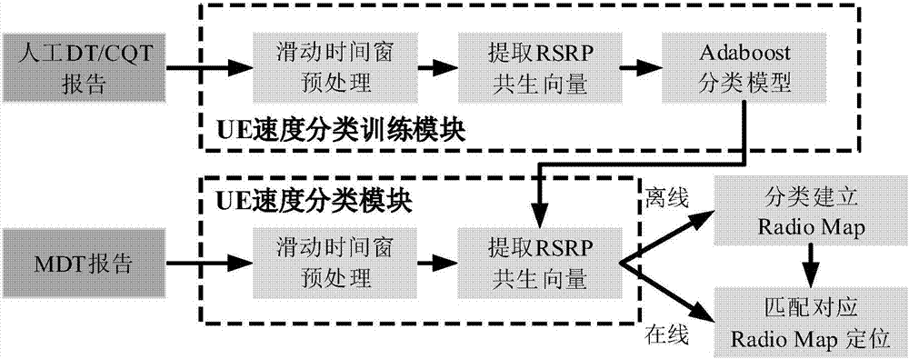
[0030] Specific implementation mode 1: The specific process of a UE speed-based Radio Map classification and positioning method in this implementation mode is as follows:

[0031] Step 1, obtaining DT, CQT and MDT sampling points;

[0032] The DT is a drive test; the CQT is a call quality test, and the MDT is a minimum drive test;

[0033] Step 2. Extract RSRP co-occurrence vectors from the DT / CQT / MDT sampling points obtained in Step 1;

[0034] The RSRP is a reference signal received power;

[0035] Step 3, design a strong classification function based on the Adaboost classification algorithm according to step 2;

[0036] Step 4: Use the strong classification function trained in step 3 to construct an offline Radio Map;

[0037] The Radio Map is a location fingerprint map;

[0038] Step 5. Use the strong classification function trained in step 3 and the offline Radio Map obtained in step 4 to perform online positioning.

specific Embodiment approach 2

[0039] Embodiment 2: The difference between this embodiment and Embodiment 1 is that the DT / CQT / MDT sampling points are obtained in the step 1; the specific process is:

[0040] Step 11: Obtain DT / CQT / MDT sampling point data packets from LTE network optimization data, mark DT sampling points as high-speed moving UEs, CQT sampling points as low-speed moving UEs or static UEs, and MDT sampling points without motion tags; UE is a user terminal equipment (User Equipment);

[0041] UE speed greater than or equal to 30km / h is high speed, UE speed less than 30km / h is low speed;

[0042] Step 1 and 2: Set the latitude and longitude of DT, CQT and MDT sampling points with location Carry out position gridding, and fix the sampling point position at the nearest grid node. In order to match the effective digits of longitude and latitude with the positioning accuracy of GPS, set the grid interval to 1 meter; calculated by formula (3) The longitude difference and latitude difference corr...

specific Embodiment approach 3

[0058] Specific embodiment three: the difference between this embodiment and specific embodiment one or two is: in the step two, extract the RSRP co-occurrence vector from the DT / CQT / MDT sampling point obtained in step one; the specific process is:

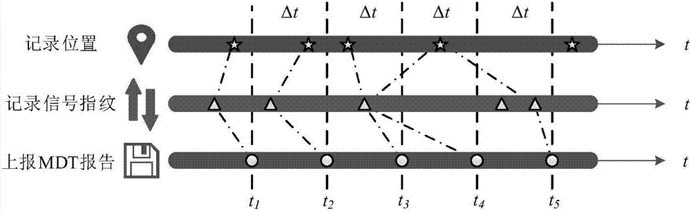
[0059] Step 21: Filter the sampling points of the same IMSI from the DT / CQT / MDT sampling points obtained in step 1, that is, the sampling points reported by the same terminal; arrange the sampling points of the same IMSI in ascending order of Timestamp; at the sampling points of the same IMSI A sliding time window is added to the sequence, the window length is 60s, and the sliding interval is 12s;

[0060] The IMSI is an International Mobile Subscriber Identity;

[0061] Timestamp measures the timestamp for the current test sampling point;

[0062] Step 22: Within a time window, select the cell c with the highest detection ratio from multiple main cells or neighboring cells detected by the UE, and extract its RSRP vector R c , ...


PUM


Abstract

The invention relates to a Radio Map classified locating method based on a UE speed. The invention aims at solving the problems of relatively short signal fingerprint in the case of low-speed UE motion and serious mismatch phenomenon in the case of high-speed UE motion under massive user LTE locating background, resulting in low locating precision. The specific process is as follows: 1, obtaining DT / CQT / MDT sampling points; 2, extracting an RSRP co-occurrence vector from the obtained DT / CQT / MDT sampling points; 3, designing a strong classification function based on an Adaboost classification algorithm according to step 2; 4, constructing an offline Radio Map by using the strong classification function trained in step 3; and 5, performing online locating by using the strong classification function trained in step 3 and the offline Radio Map obtained in step 4. The Radio Map classified locating method provided by the invention is applied to the field of locating.

Description

technical field [0001] The invention relates to a Radio Map classification and positioning method based on UE speed. Background technique [0002] In recent years, with the rapid development of communication technology and information technology and the rapid popularization of various smart devices, location-based services have attracted more and more attention. 80% of the information in daily life is related to location, which is enough to show the importance of location. On the other hand, 5G revolutionizes the concept of "Internet of Everything". For the Internet of Things and the Internet of Vehicles, the most basic characteristic of an object is "moving." important. Therefore, high-precision positioning, especially high-precision outdoor positioning, has become the focus of more and more researchers. GNSS (Global Navigation Satellite System) is the most widely used outdoor positioning technology. Although it can achieve high positioning accuracy, it is sensitive to o...

Claims


Application Information

Patent Timeline
Patent Type & Authority Applications(China)
IPC IPC(8): H04W24/10H04W64/00G06K9/62
CPCH04W24/10H04W64/006G06F18/24147
Inventor 马琳金宁迪徐玉滨
Owner HARBIN INST OF TECH
Why Eureka
Try Eureka