GIS road black spot map generation method for advanced driving assistant system application

A driving assistance system and map generation technology, applied in traffic control systems, special data processing applications, traffic control systems of road vehicles, etc., can solve problems such as different, difficult to deal with, and difficult to define black spots of accidents

Inactive Publication Date: 2017-08-18
叶昊
View PDF6 Cites 10 Cited by
  • Summary
  • Abstract
  • Description
  • Claims
  • Application Information

AI Technical Summary

Problems solved by technology

Although this method is more feasible than the accident blackspot statistical method, there are still some disadvantages, such as the specification of road connections in the navigation map may vary, and road segments may range from a few meters to hundreds of met...

Method used


Image

  • GIS road black spot map generation method for advanced driving assistant system application
  • GIS road black spot map generation method for advanced driving assistant system application
  • GIS road black spot map generation method for advanced driving assistant system application

Examples


Embodiment 1

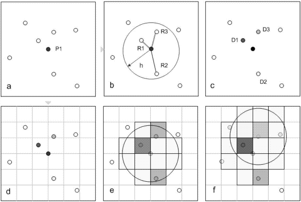
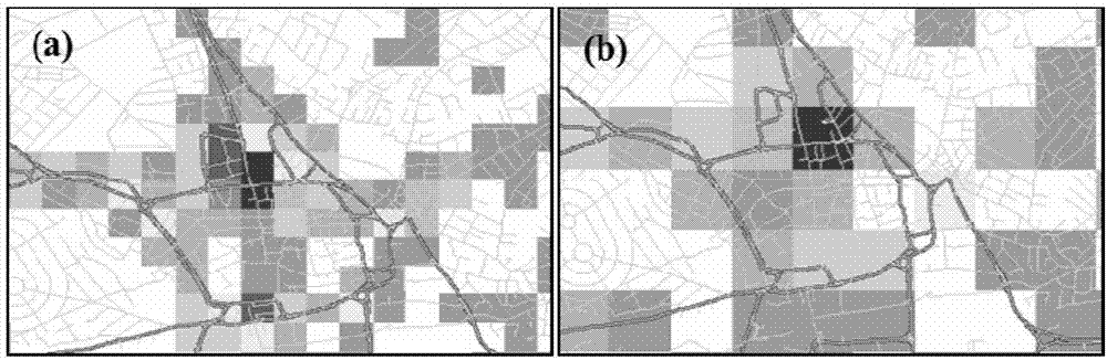
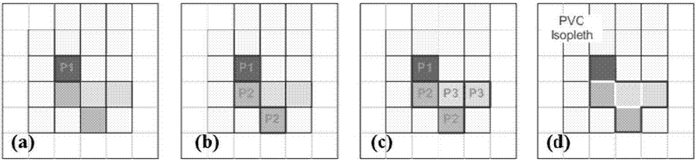
[0053] like Figure 4 As shown, the whole process of the method for generating the GIS road blackspot map in this embodiment is divided into three stages and nine steps. Among them, the data preparation stage is mainly used for the pre-data preparation and standardization work of the accident black spot extraction program. The main steps include: (1) collecting historical accident data; (2) standardizing historical accident data; (3) organizing accident data format. The analysis and extraction stage is mainly used for the specific implementation of accident black spot generation. The implementation principle is based on the method and principle shown above. The main steps include: (4) implement kernel density estimation; (5) implement volume contour extraction; (6) implement Black spot risk assessment. The data integration stage is mainly used for the specific implementation of the data blackspot extraction program. The main steps include: (7) implement blackspot data format ...


PUM


Abstract

The invention discloses a GIS road black spot map generation method for an advanced driving assistant system application, and belongs to the technical field of advanced driving assistant technologies. According to the invention, various GIS based spatial analysis and extraction methods are combined, a local dynamic map database is formed in a map layer overlapping mode with a navigation map through performing data analysis and extracting a road black spot map under the premise of being based on historical accidents, and the local dynamic map database is used for supporting various real-time ADAS applications. According to the invention, accident black spot databases required by various ADAS security applications can be acquired efficiently at a low cost. Meanwhile, back spot data can be combined with the existing navigation map according to the method so as to generate a black spot database, thereby providing effective data support for various types of road real-time black spot security applications.

Description

technical field [0001] The invention relates to the technical field of advanced driving assistance, and more specifically, relates to a method for generating a GIS road black-spot map for application of an advanced driving assistance system. Background technique [0002] In order to improve the safety of road traffic, Advanced Driver Assistance System (ADAS) and its related vehicle technologies have received extensive attention from the automotive industry. So far, many advanced driver assistance systems have been developed and applied, such as lane departure warning systems, adaptive cruise control systems, and so on. With the research and development of related systems, various ADAS system applications have put forward higher requirements for the recognition of the driving environment and its corresponding digital map database. [0003] To develop ADAS applications, more details and data about roads need to be integrated into digital maps. Therefore, it is particularly i...

Claims


Application Information

Patent Timeline
IPC IPC(8): G08G1/0967G06F17/30
CPCG06F16/29G08G1/0967
Inventor 叶昊
Owner 叶昊
Why Eureka
Try Eureka