Unmanned aerial vehicle trajectory planning method based on EB-RRT

A technology of EB-RRT and track planning, applied in navigation calculation tools, three-dimensional position/course control, complex mathematical operations, etc., can solve problems such as poor practicability, low operating efficiency, and slow convergence speed

Inactive Publication Date: 2017-08-22
ZHEJIANG UNIV OF TECH
View PDF5 Cites 64 Cited by
  • Summary
  • Abstract
  • Description
  • Claims
  • Application Information

AI Technical Summary

Problems solved by technology

[0009] In order to overcome the disadvantages of the existing unmanned aerial vehicle track planning method, such as slow convergence speed, poor flexibility, low operating efficiency, and poor practicability, the present invention provides a fast convergence speed, good flexibility, EB-RRT-based UAV track planning method with high operating efficiency and good practicability

Method used


Image

  • Unmanned aerial vehicle trajectory planning method based on EB-RRT
  • Unmanned aerial vehicle trajectory planning method based on EB-RRT
  • Unmanned aerial vehicle trajectory planning method based on EB-RRT

Examples


Embodiment Construction

[0047] The present invention will be further described below in conjunction with the accompanying drawings.

[0048] The present invention will be further described below in conjunction with the accompanying drawings.

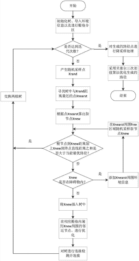
[0049] refer to figure 1 , a UAV track planning method based on EB-RRT, including the following steps:

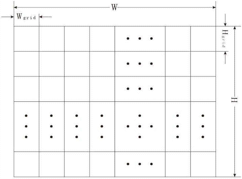
[0050] Step1: Import environmental information, and perform grid partition processing on the map environment, in preparation for the subsequent search for nearby node sets.

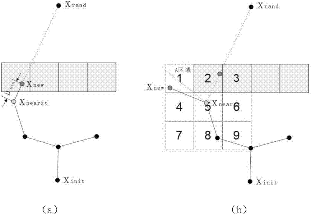
[0051] Step2: Generate a random point x rand , find the node x closest to the random point among the existing nodes nearst .

[0052] Step3: Calculate the insertion point x according to the step size new . If the root node to x new distance from x new If the sum of the Euclidean distances to the end point is greater than the length of the current optimal path, skip this iteration; otherwise, enter Step4.

[0053] Step4: to x new Whether the point is detected within the obstacl...


PUM


Abstract

The invention provides an unmanned aerial vehicle trajectory planning method based on EB-RRT. The method comprises the steps that grid partitioning is carried out on a map environment; a node xnearst nearest to a random point in existing nodes is found; an insertion point xnew is calculated according to the step length; if the sum of the distance between a root node to xnew and the Euclidean distance between xnew and the end is not greater than the length of the current optimal path, whether the xnew point is in an obstacle is detected; if not, the surrounding environment information of xnearst is collected, and a new insertion point xnew is randomly sampled in the surrounding free area; xnew is inserted into a tree; the nearby node set of xnew is traversed and found in the corresponding grid, and the path of the nearby nodes is optimized; connection detection is carried out on two trees into which the xnew point is inserted; if not, two trees are exchanged, and random points continue to be sampled; if so, a feasible path is found, and downsampling is carried out; and a Bessel cubic interpolation algorithm is used to optimize the new path. The unmanned aerial vehicle trajectory planning method provided by the invention has the advantages of high convergence speed, good flexibility, high running efficiency and good practicability.

Description

technical field [0001] The invention belongs to the field of unmanned aerial vehicle motion planning, in particular to a method for autonomous track planning of an unmanned aerial vehicle. Background technique [0002] Trajectory planning is an important problem in UAV navigation and robotics. Its basic definition is: given an initial state and a target state, find a feasible trajectory to make the UAV run from the initial state to the target state without collision. . Trajectory planning has a wide range of application scenarios: GPS navigation, driverless cars, computer animation, routing problems, robotic arm motion in the manufacturing industry and life, and many aspects of the industrial field. Therefore, the research on trajectory planning has become a research hotspot in recent years. [0003] UAV track planning algorithm can be divided into local track planning and global track planning according to its perception ability. The global track planning is to plan in th...

Claims


Application Information

Patent Timeline
Patent Type & Authority Applications(China)
IPC IPC(8): G05D1/10G01C21/20G06F17/11
CPCG05D1/101G01C21/20G06F17/11
Inventor 陈晋音李玉玮
Owner ZHEJIANG UNIV OF TECH
Why Eureka
Try Eureka