UAV (unmanned aerial vehicle) base station location and patrol path optimization method and device

A path optimization and unmanned aerial vehicle technology, applied in the field of unmanned aerial vehicles, can solve the problems of difficulty in finding small-scale criminal acts and low patrol precision, and achieve the effect of optimal location path planning scheme and reduced patrol cost

Active Publication Date: 2017-10-27
NAT UNIV OF DEFENSE TECH
View PDF5 Cites 21 Cited by
  • Summary
  • Abstract
  • Description
  • Claims
  • Application Information

AI Technical Summary

Problems solved by technology

However, as a large UAV, "Predator B" is more used for high-altitude monitoring. On the one hand, its flight route needs to be controlled and dispatched. On the other hand, in areas covered by leaves or other objects such as woods, high-altitude monitoring Difficult to detect small-scale crimes, low patrol accuracy

Method used


Image

  • UAV (unmanned aerial vehicle) base station location and patrol path optimization method and device
  • UAV (unmanned aerial vehicle) base station location and patrol path optimization method and device
  • UAV (unmanned aerial vehicle) base station location and patrol path optimization method and device

Examples


Embodiment Construction

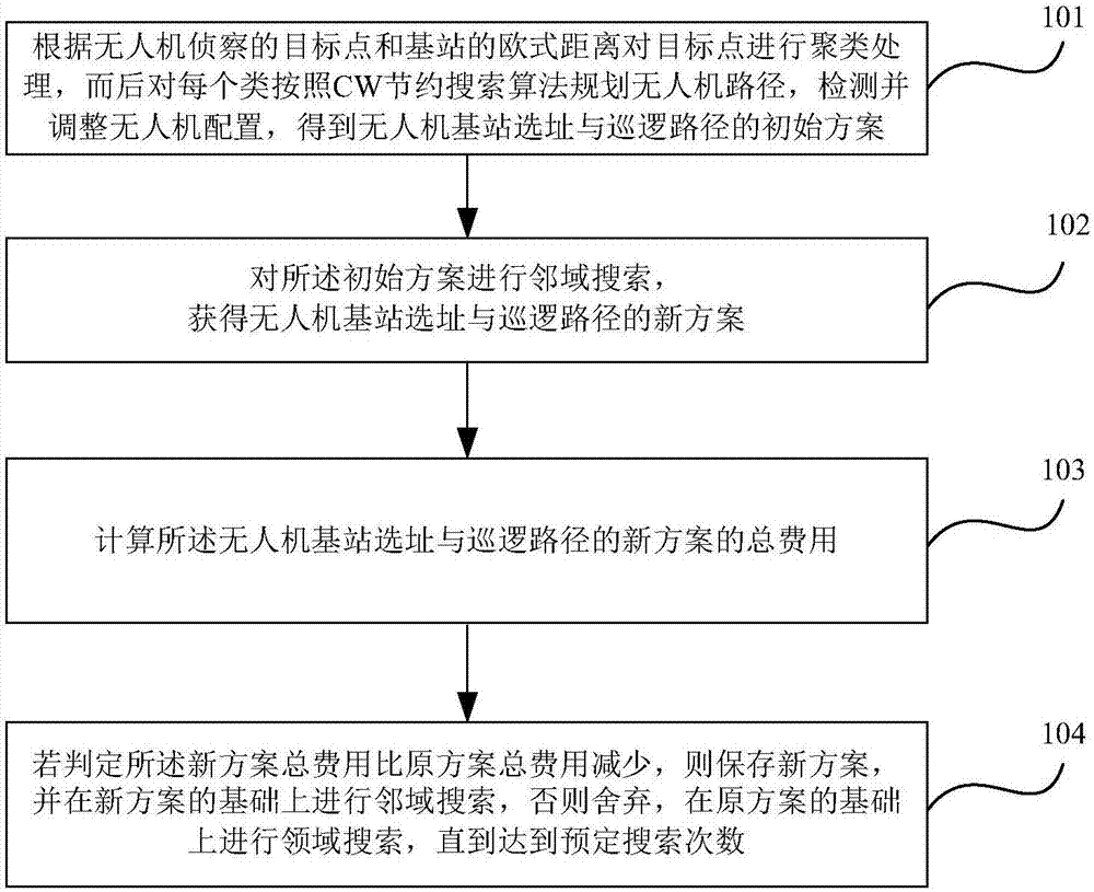
[0030] The following will clearly and completely describe the technical solutions in the embodiments of the present invention with reference to the accompanying drawings in the embodiments of the present invention. Obviously, the described embodiments are only some, not all, embodiments of the present invention. Based on the embodiments of the present invention, all other embodiments obtained by persons of ordinary skill in the art without making creative efforts belong to the protection scope of the present invention.

[0031] The embodiment of the present invention conducts research on the site selection of deployment base stations and patrol route planning in UAV border patrols. Relying on the existing border defense force facilities, border guard posts are used as candidate base stations for deploying UAVs, and important border patrol areas For patrol and reconnaissance targets, establish a mathematical programming model for the integrated optimization of UAV base station s...


PUM


Abstract

The invention provides an UAV (unmanned aerial vehicle) base station location and patrol path optimization method and device. The method comprises the following steps: carrying out clustering processing on target points according to Euclidean distance between the target points detected by a UAV and each base station, then, for each class, planning UAV paths according to a CW saving search algorithm, and with UAV patrol paths being constrained by UAV endurance time, detecting and adjusting UAV configuration to obtain an UAV base station location and patrol path initial scheme; carrying out neighborhood search based on the initial scheme to obtain an UAV base station location and patrol path new scheme obtained after neighborhood adjustment; calculating total cost of the UAV base station location and patrol path new scheme; if judging that the total cost of the new scheme is smaller than the total cost of the initial scheme, keeping the new scheme and carrying out neighborhood search based on the new scheme; or otherwise, rejecting the new scheme and carrying out neighborhood search again until reaching preset neighborhood search times. According to the technical scheme above, cost in UAV (unmanned aerial vehicle) base station location and patrol path is allowed to be minimum.

Description

technical field [0001] The invention relates to the technical field of unmanned aerial vehicles, in particular to a method and device for site selection and patrol path optimization of unmanned aerial vehicle base stations. Background technique [0002] In recent years, crimes such as smuggling, smuggling, and terrorist activities in border areas have become increasingly serious, and the forms of crime have shown a trend of diversification, intelligence, and concealment, which put forward higher requirements for the monitoring capabilities and response speed of border guards. Moreover, most of my country's land borders are high mountains and desert areas, with complex geographical locations and harsh environments. Traditional border monitoring methods such as guards and manual patrols are inefficient, dangerous, and slow to respond, and cannot meet the needs of the current border situation. The monitoring method of installing cameras cannot be widely used because of its high...

Claims


Application Information

Patent Timeline
Patent Type & Authority Applications(China)
IPC IPC(8): G05D1/10
CPCG05D1/101
Inventor 刘忠刘瑶石建迈陈超罗志浩张家铭王玥周天任
Owner NAT UNIV OF DEFENSE TECH
Why Eureka
Try Eureka