Road network hot spot region mining method

A technology of hotspot area and road network, applied in the fields of structured data retrieval, instruments, electronic digital data processing, etc., can solve the problem of clustering results, large response time, and inability to accurately express the distance between two trajectories in the road network. and other problems, to achieve the effect of fast response time, best effect, and saving storage space overhead.

Active Publication Date: 2017-10-27
UNIV OF ELECTRONIC SCI & TECH OF CHINA
View PDF4 Cites 34 Cited by
  • Summary
  • Abstract
  • Description
  • Claims
  • Application Information

AI Technical Summary

Problems solved by technology

[0004] The purpose of the present invention is to solve the problem that in the prior art, when trajectory clustering is performed using trajectory spatiotemporal similarity measure and clustering calculation, when the amount of trajectory data is large, the response time of the spatiotemporal similarity measure is relatively large; European coordinates cannot be accurately expressed The distance b

Method used


Image

  • Road network hot spot region mining method
  • Road network hot spot region mining method
  • Road network hot spot region mining method

Examples


Embodiment Construction

[0067] In order to make the object, technical solution and advantages of the present invention clearer, the present invention will be further described in detail below in conjunction with the accompanying drawings and embodiments. It should be understood that the specific embodiments described here are only used to explain the present invention, not to limit the present invention.

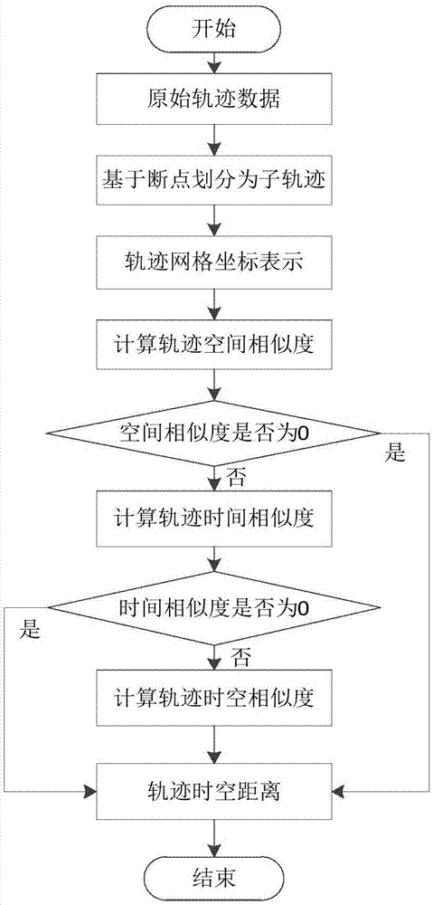
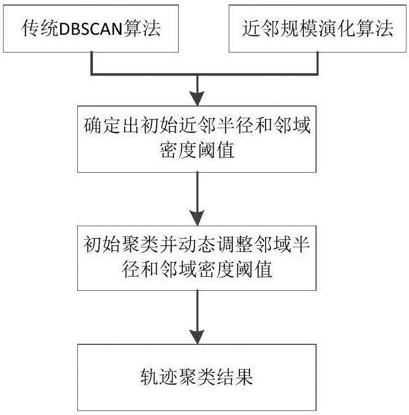
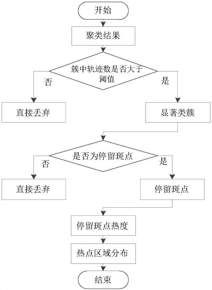
[0068] The invention provides a road hotspot region mining method. By performing dynamic nearest neighbor optimization DBSCAN clustering on vehicle trajectories and calculating the heat of staying spots, the mining effect of road hotspot areas can be accurately and effectively improved. The disadvantage that the clustering results are greatly affected by the artificially input parameter values ​​is overcome by the DBSCAN clustering algorithm based on dynamic nearest neighbors. By calculating the heat information of the stay spots, the distribution of hot spots can be described more accurately.

...


PUM


Abstract

The invention discloses a road network hot spot region mining method, belongs to the technical field of data mining and solves the problem when trajectory spatial-temporal similarity measurement and clustering calculation is adopted for trajectory clustering in the prior art. The method includes: step 1, performing trajectory segmentation on all trajectory sections, and calculating spatial-temporal similarity and spatial-temporal distance between two sub trajectory sections acquired after segmentation; step 2, performing clustering calculation on all trajectory section data in a grid space according to the spatial-temporal similarity and the spatial-temporal distance of the sub trajectories and a DBSCAN algorithm based on dynamic neighbor; step 3, selecting a remarkable class cluster set from class clusters of clustering calculation, and extracting stay spots from the remarkable class cluster set; step 4, according to the number of trajectory sections carried by the stay spots, acquiring hot regions of the stay spots, and acquiring hot spot regions in a road network from the regions where the stay spots are positioned. The method is used for spatial position locating.

Description

technical field [0001] A road network hotspot area mining method is used for spatial location positioning and belongs to the technical field of data mining. Background technique [0002] In recent years, the rapid development and application of spatial location positioning technology, along with the rapid popularization of these technologies, we can easily track the location information of almost any moving object, thus forming a huge trajectory database in the form of trajectory, these massive trajectory The data contains a large amount of deep information that can reflect certain motion behaviors of moving objects. As a kind of spatiotemporal data, spatiotemporal trajectory data mainly records the trend of the spatial position of moving objects over time, while vehicle spatiotemporal trajectory data is more special because it is limited to the road network. Therefore, the commonly used data mining methods Many of them cannot be directly applied to spatio-temporal trajecto...

Claims


Application Information

Patent Timeline
IPC IPC(8): G06F17/30G06K9/46G06K9/62
CPCG06F16/2462G06F16/285G06F16/9537G06V10/462G06F18/2321
Inventor 田玲罗光春殷光强陈爱国
Owner UNIV OF ELECTRONIC SCI & TECH OF CHINA
Why Eureka
Try Eureka