Unmanned aerial vehicle-based data acquisition method and system for individual building modeling

A technology for data acquisition and unmanned aerial vehicles, which is applied in control/regulation systems, measuring devices, instruments, etc., and can solve the problems of incomplete side texture information and low degree of refinement of modeling results.

Active Publication Date: 2017-12-26
TONGJI UNIV +1
View PDF4 Cites 25 Cited by
  • Summary
  • Abstract
  • Description
  • Claims
  • Application Information

AI Technical Summary

Problems solved by technology

[0005] The technical problem to be solved by the present invention is to overcome the incomplete side texture information of a single building captured by a measuring drone when modeling a single building in the prior art, which ultimately leads to a low degree of refi

Method used


Image

  • Unmanned aerial vehicle-based data acquisition method and system for individual building modeling
  • Unmanned aerial vehicle-based data acquisition method and system for individual building modeling
  • Unmanned aerial vehicle-based data acquisition method and system for individual building modeling

Examples


Embodiment 1

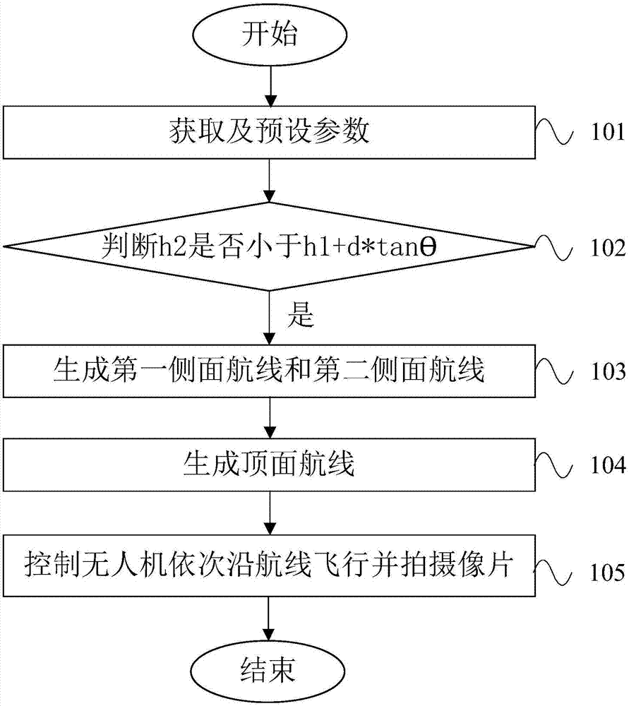
[0108] Such as figure 1 As shown, a UAV-based data acquisition method for single building modeling, the single building includes a top surface, several sides and the joint between surfaces, the UAV carries a camera, and the The data collection method includes the following steps:

[0109] Step 101, obtaining the building height h of the single building 1 , the safe height h of the UAV 2 , the default lateral overlap P 1 and heading overlap P 2 , the initial distance d between the preset camera and the shooting surface, the value of the preset shooting angle θ, fov 1 / 21 Indicates the vertical field of view of the camera;

[0110] Step 102, judge h 2 Is it less than h 1 +d*tanθ, if so, execute step 103;

[0111] Step 103, the height for the side is greater than or equal to the safety height h 2 The part of generates a number of first side routes surrounding the side, the distance between the first side route and the side to be photographed is equal to d, the first side...

Embodiment 2

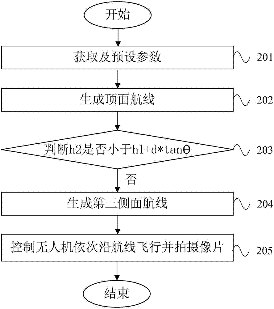
[0128] Such as figure 2 As shown, the difference from Example 1 is that in this example h 2 greater than h 1 +d*tanθ, the data collection method comprises the following steps:

[0129] Step 201, obtain the building height h of the single building 1 , the safe height h of the UAV 2 , the default lateral overlap P 1 , preset heading overlap P 2 , the initial distance d between the preset camera and the shooting surface, the value of the preset shooting angle θ, fov 1 / 21 Indicates the vertical field of view of the camera;

[0130] Step 202, using the route planning method of aerial photogrammetry on the top surface to generate the top surface route;

[0131] Step 203, judge h 2 Is it less than h 1 +d*tanθ, otherwise execute step 204;

[0132] Step 204, generate a number of third side routes around the side, the height of the third side routes is h 2 , the third side routes are distributed at intervals along the horizontal direction, and the third side routes are para...

Embodiment 3

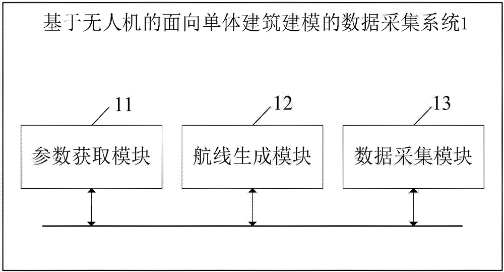
[0142] Such as Figures 3 to 5 As shown, a UAV-based data acquisition system 1 for modeling of a single building, the single building includes a top surface, several sides and the junction between surfaces, the UAV carries a camera, and the The data acquisition system 1 includes a parameter acquisition module 11, a route generation module 12 and a data acquisition module 13; the route generation module 12 includes a judgment module 1201, a top route generation module 1202, a first side route generation module 1203, a second side A route generation module 1204 and a third side route generation module 1205; the data collection module 13 includes a top data collection module 1301 , a first data collection module 1302 and a second data collection module 1303 .

[0143] The parameter acquisition module 11 is used to acquire the building height h of the single building 1 and the safe height h of the UAV 2 , the parameter acquisition module 11 is also used to preset the degree of l...


PUM


Abstract

The invention discloses an unmanned aerial vehicle-based data acquisition method and system for individual building modeling. The data acquisition method comprises the following steps: S1, acquiring a building height h1 and a sidelap degree P1 of an individual building; S2, according to the building height h1, generating a plurality of side surface air lines around a side surface; and S3, controlling an unmanned aerial vehicle to fly along the side surface air lines in sequence and take images so as to complete data acquisition from the bottom end to the top end of the side surface, wherein images between every two adjacent side surface air lines meet the sidelap degree P1. According to the unmanned aerial vehicle-based data acquisition method and system for individual building modeling, three-dimensional air line surrounding data acquisition of the individual building is implemented by using the measurement type unmanned aerial vehicle, precise information of the building is rapidly and conveniently is achieved in all directions by planning side surface air lines, and the problem that side surface information of a building is lost after conventional aerial photogrammetry is solved.

Description

technical field [0001] The invention relates to the technical field of route planning and data acquisition of surveying drones, in particular to a data acquisition method and system based on drones for single building modeling. Background technique [0002] Three-dimensional GIS (Geographic Information System, Geographic Information System) is one of the main symbolic contents of GIS technology today and even in the future. Provides more effective auxiliary decision support. For the construction industry and surveying and mapping, scalable 3D models are essential. [0003] UAV remote sensing technology is currently one of the means to obtain surface information at low altitude. It is controlled by radio remote control equipment and ground control system, and has the advantages of small size, light weight, slow flight speed and wide shooting range. Because this technology has the characteristics of fast, safe and economical, it has become a research hotspot all over the wor...

Claims


Application Information

Patent Timeline
IPC IPC(8): G01C11/00G05D1/10
CPCG01C11/00G05D1/101
Inventor 刘春周骁腾周政张书航周源曾勇
Owner TONGJI UNIV
Why Eureka
Try Eureka