Space querying method based on interaction-type sketch

A spatial query and interactive technology, applied in the information field, can solve the problem that it is difficult to cross the semantic gap of geographical scenes, difficult to realize multi-geographic entities, complex queries of geographical entities and spatial relationships, and inability to effectively describe and express multi-level and multi-level geographical scenes. The coexistence of various geographical phenomena and the interaction of geographical complexes, etc., to achieve the effect of reducing complexity

Inactive Publication Date: 2018-01-19
NANJING UNIV OF POSTS & TELECOMM
View PDF3 Cites 2 Cited by
  • Summary
  • Abstract
  • Description
  • Claims
  • Application Information

AI Technical Summary

Problems solved by technology

(1) The existing abstraction of geographic space focuses on the expression of the location, geometry, attributes, time and spatial relationship of individual geographical phenomena, which is difficult to bridge the "semantic gap" of geographical scenes, and cannot effectively describe and express the multi-level and multi-layered geographic scenes. Geographical com

Method used


Image

  • Space querying method based on interaction-type sketch
  • Space querying method based on interaction-type sketch
  • Space querying method based on interaction-type sketch

Examples


Embodiment Construction

[0031] The technical solution of the present invention will be described in detail below in conjunction with the accompanying drawings.

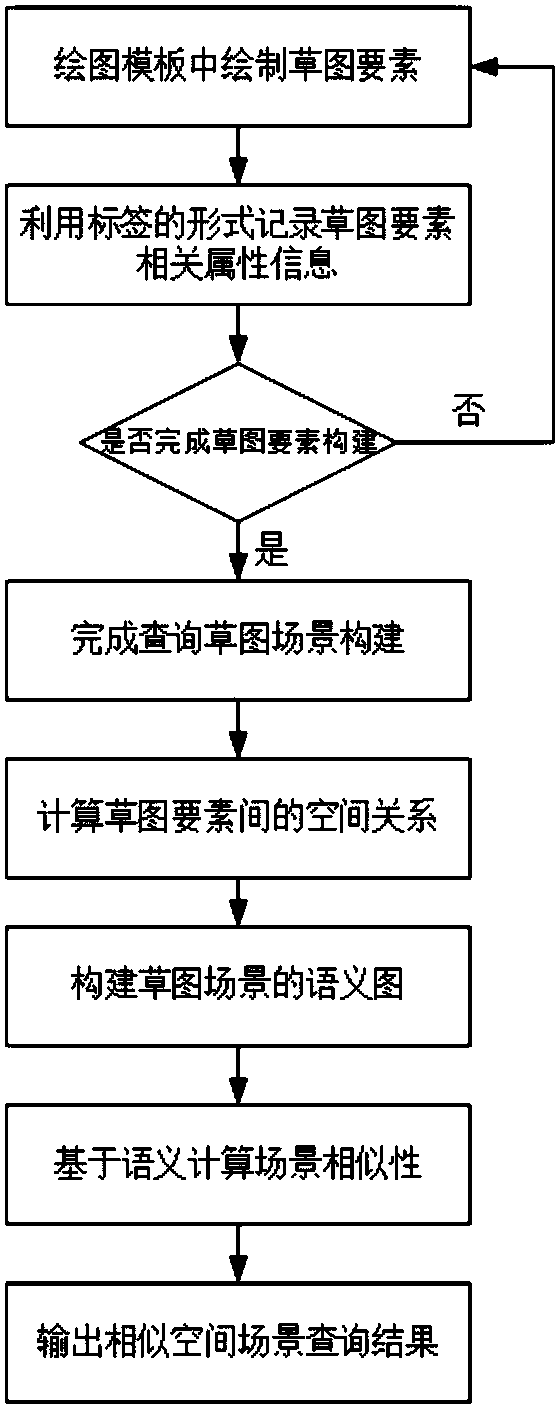
[0032] Taking the following query as an example, it includes three types of information: 1) query subject; 2) confirmed auxiliary information 3) uncertain auxiliary information, as shown in Table 1. In this example, the fuzzy object to be queried is a hotel whose name is unknown; it can be determined that the hotel is next to "Wenlan Road", surrounded by hills and a lake in front; at the same time, there may be a road behind the hotel.

[0033] Table 1 query example

[0034]

[0035] (1) If figure 2 As shown in , draw the elements to be queried in the drawing template, and the system will automatically record the user name, creation time, and modification time. Users can edit the element name, Tag and other information, and the Tag information can be added arbitrarily through the plus sign. During the drawing process, the stroke, thic...


PUM


Abstract

The invention discloses a space querying method based on an interaction-type sketch. The method is suitable for use in electronic map-oriented fuzzy scene querying, solves contradiction between increasingly-rich geographical data and a single current space querying mode and result display form, and includes the following steps: (1) providing a space querying-oriented sketch scene construction environment, in which elements can be drawn through strokes in a drawing process, and forms of tags and the like can be utilized to input attribute information of the elements; (2) calculating space relationships between the sketch elements; (3) constructing a semantic graph of a sketch scene; (4) calculating scene similarity on the basis of semantics; and (5) outputting similar space scene querying results. According to the method, the interaction-type sketch is applied to space querying, multi-element scene matching is converted into semantic similarity degree calculation, and modes of geographical information retrieval can be effectively expanded.

Description

technical field [0001] The invention belongs to the field of information technology, in particular to a geographical scene-oriented electronic map space query method. Background technique [0002] Spatial query is one of the main functions of GIS. Traditional spatial query uses spatial objects, spatial relationships, attributes, etc., and cannot solve the problem of multi-element and fuzzy element query. In recent years, in order to meet the needs of geospatial query in specific fields and scenarios, research in related fields at home and abroad has achieved certain research results, but there are still some problems that need to be solved urgently. (1) The existing abstraction of geographic space focuses on the expression of the location, geometry, attributes, time and spatial relationship of individual geographical phenomena, which is difficult to bridge the "semantic gap" of geographical scenes, and cannot effectively describe and express the multi-level and multi-layered...

Claims


Application Information

Patent Timeline
IPC IPC(8): G06F17/30G06F17/27
Inventor 朱少楠姜杰
Owner NANJING UNIV OF POSTS & TELECOMM
Why Eureka
Try Eureka