Method and system for automatically extracting building outline of static three-dimensional map

A static three-dimensional, automatic extraction technology, applied in the field of geographic information, can solve the problem of difficulty in automatic and accurate extraction of building model outlines

Inactive Publication Date: 2018-03-06
武汉市国土资源和规划信息中心
View PDF10 Cites 21 Cited by
  • Summary
  • Abstract
  • Description
  • Claims
  • Application Information

AI Technical Summary

Problems solved by technology

[0013] The purpose of the present invention is to overcome the deficiency that the existing static three-dimensional map building model outlines are difficult to automatically and accurately extract, and to provide a method and system for automat

Method used


Image

  • Method and system for automatically extracting building outline of static three-dimensional map
  • Method and system for automatically extracting building outline of static three-dimensional map
  • Method and system for automatically extracting building outline of static three-dimensional map

Examples


Embodiment Construction

[0085] The present invention will be further described in detail below in conjunction with the accompanying drawings and specific embodiments.

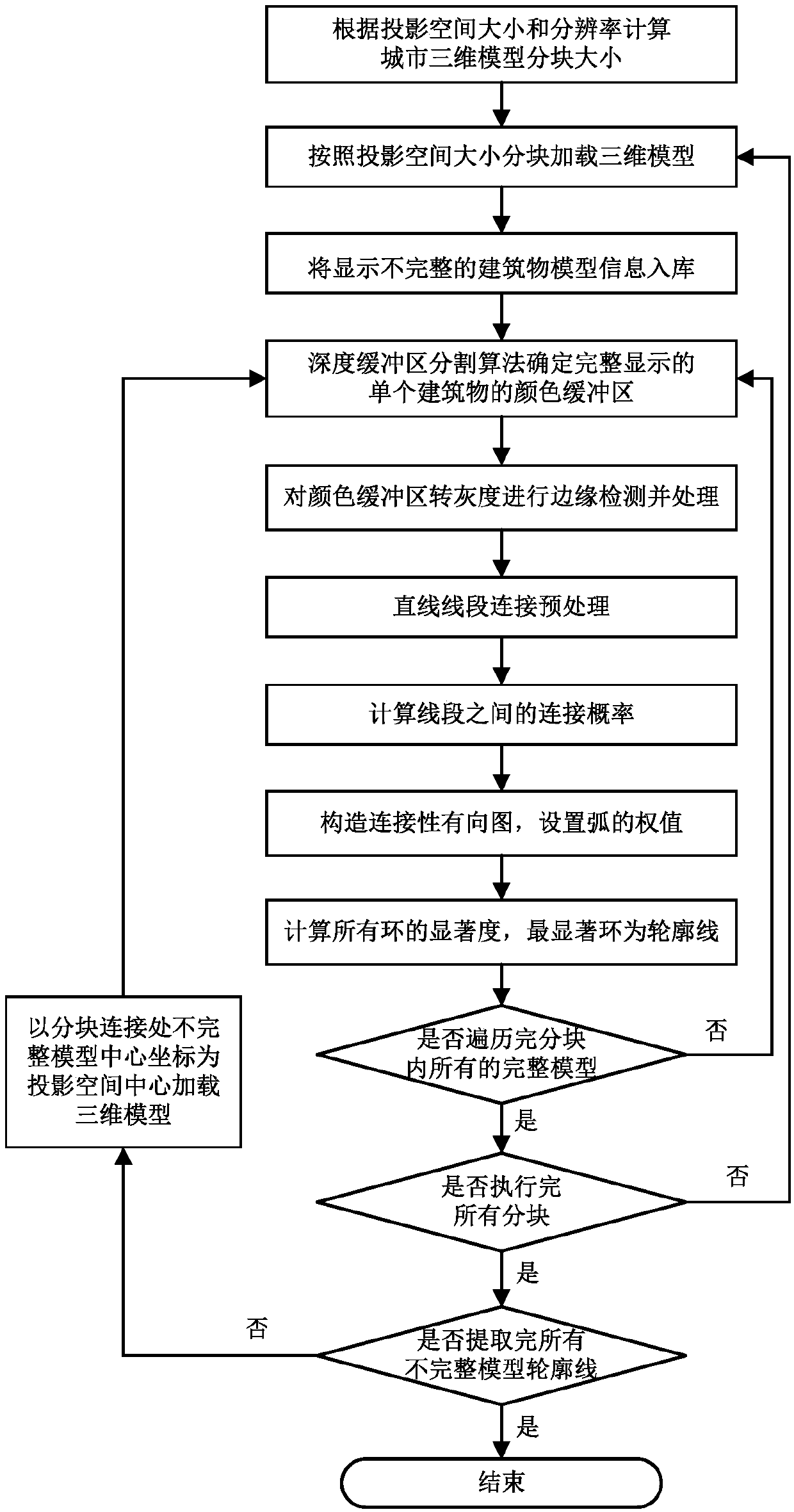
[0086] see figure 1 As shown, the embodiment of the present invention provides a method for automatically extracting building outlines from a static three-dimensional map, comprising the following steps:

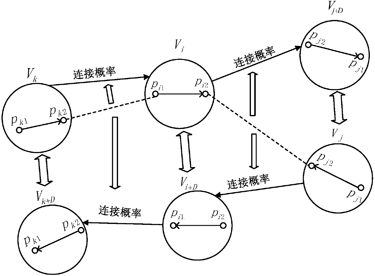
[0087]S1. According to the spatial resolution of the side-view map and the size of the frame buffer, determine the block size of the city's 3D model, divide the city's 3D model into blocks, and create a database for storing and displaying incomplete model information. The model ID is used as the model unique identifier of

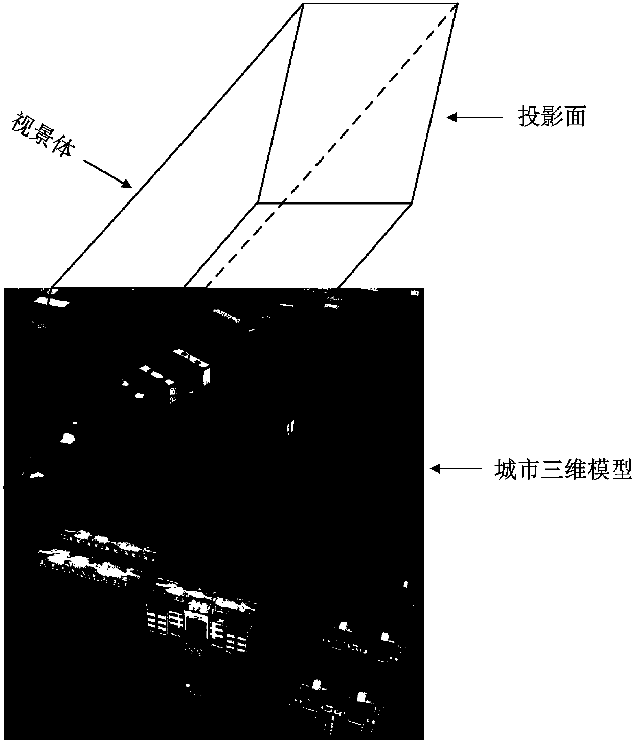
[0088] S2. Load the city 3D model within the current block range to the memory, and judge whether the vertices of the 3D model of each building are in the projection space. If any vertices are not in the projection space, it is determined that the model is incompletely displayed, and the database is judged accor...


PUM


Abstract

The invention discloses a method and system for automatically extracting a building outline of a static three-dimensional map, and relates to the field of geographic information technology. The methodincludes the steps of loading a three-dimensional model in blocks according to the frame buffer size and the map resolution; obtaining a color buffer of a single building object by using a depth buffer partitioning algorithm; performing edge detection by using a Canny operator; then performing edge processing and connecting straight line segments; and next, based on the graph theory, taking a line segment as a vertex and the connection probability of the line segment as the weight of an arc, grouping the line segments by a perceptual organization method, and extracting the outline of a building model. The method and system in the invention can automatically and reliably extract the building outline in the static three-dimensional map from any angle of view.

Description

technical field [0001] The invention relates to the technical field of geographic information, in particular to a method and system for automatically extracting building outlines from a static three-dimensional map. Background technique [0002] Traditional two-dimensional maps cannot truly and completely reflect the real world, and three-dimensional maps have complex data structures, large data volumes, and low loading efficiency. Static 3D map is a 2D map that shows the effect of 3D model. It not only has the advantages of 2D map in data collection, analysis and processing, but also has intuitive and real spatial performance capabilities, and has a small amount of data and fast online transmission speed. Fast, satisfying the quick browsing access to the 3D map in the existing network environment. Static 3D maps make up for the shortcomings of 2D and 3D maps, but they are raster images that cannot directly manipulate a single object. Therefore, it is necessary to extract t...

Claims


Application Information

Patent Timeline
IPC IPC(8): G06T7/11G06T7/13G06T7/136G06T7/62G06T17/05
CPCG06T7/11G06T7/13G06T7/136G06T7/62G06T17/05G06T2207/10012G06T2207/10024
Inventor 邵世维黄新刘辉李庚勤
Owner 武汉市国土资源和规划信息中心
Why Eureka
Try Eureka