Method and device for obtaining conversion parameters, and mobile mapping system

A technology for converting parameters and measuring systems, which is applied in the field of mobile mapping, and can solve problems such as difficult and cumbersome acquisition of high-precision initial conversion parameters

Active Publication Date: 2018-03-13
NAVINFO
View PDF10 Cites 8 Cited by
  • Summary
  • Abstract
  • Description
  • Claims
  • Application Information

AI Technical Summary

Problems solved by technology

[0006] Therefore, the technical problem to be solved by the embodiments of the present invention is that the calibration of the external parameters of the laser scan...

Method used


Image

  • Method and device for obtaining conversion parameters, and mobile mapping system
  • Method and device for obtaining conversion parameters, and mobile mapping system
  • Method and device for obtaining conversion parameters, and mobile mapping system

Examples


Embodiment 1

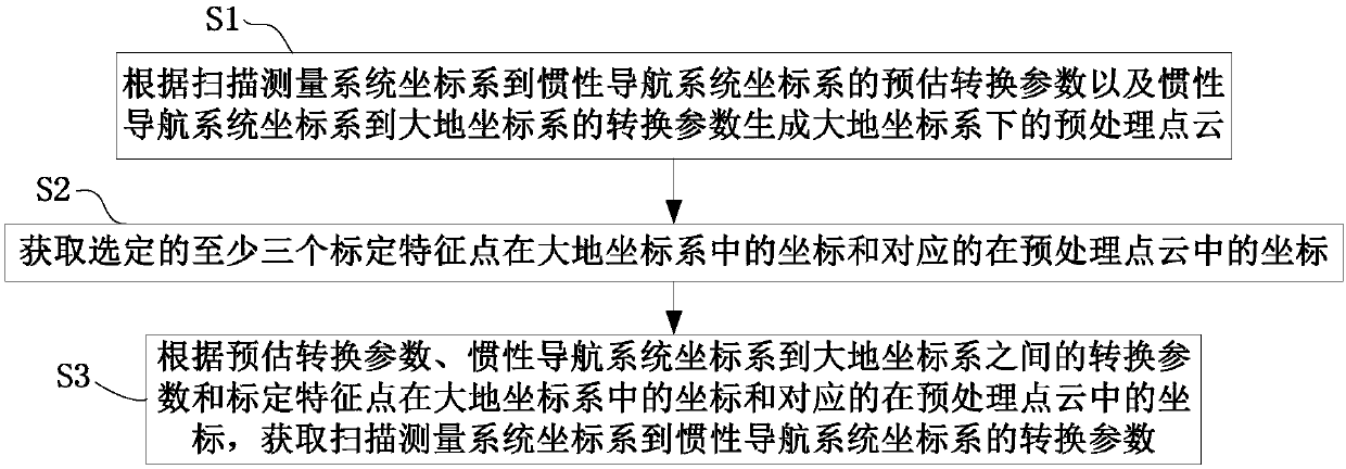
[0056] This embodiment provides a method for obtaining the conversion parameters from the coordinate system of the scanning measurement system to the coordinate system of the inertial navigation system, such as figure 1 shown, including:

[0057] S1. Generate a preprocessed point cloud in the geodetic coordinate system according to the estimated conversion parameters from the scanning measurement system coordinate system to the inertial navigation system coordinate system and the conversion parameters from the inertial navigation system coordinate system to the geodetic coordinate system. Preferably, the scanning measurement system can be a device with a scanning function such as a laser scanner (Laser), and the corresponding scanning measurement system coordinate system is the laser scanner coordinate system at this time; the inertial navigation system (INS) is based on a gyroscope and an accelerometer It is a navigation parameter calculation system for sensitive devices. The...

Embodiment 2

[0090] This embodiment provides a device for obtaining conversion parameters from the coordinate system of the scanning measurement system to the coordinate system of the inertial navigation system, such as Figure 5 shown, including:

[0091] The preprocessing point cloud generation unit 11 is used to generate the preprocessing under the earth coordinate system according to the estimated conversion parameters from the scanning measurement system coordinate system to the inertial navigation system coordinate system and the conversion parameters between the inertial navigation system coordinate system and the earth coordinate system point cloud. Preferably, the scanning measurement system is a laser scanner.

[0092] The corresponding coordinate generating unit 12 is configured to obtain the coordinates of the selected at least three calibration feature points in the earth coordinate system and the corresponding coordinates in the pre-processed point cloud.

[0093] The calcu...

Embodiment 3

[0110] This embodiment provides a mobile mapping system, including the device in Embodiment 2 for obtaining conversion parameters from the coordinate system of the scanning measurement system to the coordinate system of the inertial navigation system.


PUM


Abstract

The embodiment of the invention provides a method and device for obtaining conversion parameters of a scanning measurement system coordinate system to an inertial navigation system coordinate system,and a mobile mapping system; the method comprises the steps: firstly, according to forecasted conversion parameters of the scanning measurement system coordinate system to the inertial navigation system coordinate system, and conversion parameters of the inertial navigation system coordinate system to a ground coordinate system, generating a pretreatment point cloud under the ground coordinate system; followed by obtaining coordinates of at least three selected calibration characteristic points in the ground coordinate system and corresponding coordinates in the pretreatment point cloud; and finally, according to the forecasted conversion parameters, the conversion parameters of the inertial navigation system coordinate system to the ground coordinate system and the coordinates of at leastthree selected calibration characteristic points in the ground coordinate system and the corresponding coordinates in the pretreatment point cloud, obtaining the conversion parameters of the scanningmeasurement system coordinate system to the inertial navigation system coordinate system. Accurate initial conversion parameters are not needed to obtain and the external calibration efficiency is improved.

Description

technical field [0001] The present invention relates to the technical field of mobile mapping, in particular to a method and device for obtaining conversion parameters from a scanning measurement system coordinate system to an inertial navigation system coordinate system, and a mobile mapping system. Background technique [0002] Mobile Mapping System (Mobile Mapping System) is a vehicle-mounted mobile fast data acquisition system based on the integration of Inertial Navigation System (INS for short), laser scanner and image sensor. During the driving process of the acquisition vehicle, the laser scanner continuously scans the surrounding environment and collects the reflected original scanning data. The on-board processor decodes the original scanning data to obtain the coordinates of the points in the laser scanner coordinate system and their corresponding high-precision scanning time, and the POS data (including the speed and position of the vehicle in the inertial naviga...

Claims


Application Information

Patent Timeline
IPC IPC(8): G01C11/00
CPCG01C11/00
Inventor 黄承猛
Owner NAVINFO
Why Eureka
Try Eureka