Method of intelligent remote-sensing image understanding of describing ground-object space relationship semantics

A remote sensing image and spatial relationship technology, applied in the field of image vision intelligent semantic understanding, can solve the problems of different resolutions, difficult to achieve personalized features, complex ground objects, etc., to achieve easy implementation, improve the ability of image understanding and description, The effect of streamlining steps

Active Publication Date: 2018-03-16
CENT SOUTH UNIV
View PDF2 Cites 11 Cited by
  • Summary
  • Abstract
  • Description
  • Claims
  • Application Information

AI Technical Summary

Problems solved by technology

However, these databases are only applicable to the field of natural images, and do not involve remote sensing images. For remote sensing images, which have rich sources, different resolutions, numerous image contents, complex ground objects, and many factors such as being easily affected by the external environment, it is difficult to achieve in-depth level of understanding

Method used


Image

  • Method of intelligent remote-sensing image understanding of describing ground-object space relationship semantics
  • Method of intelligent remote-sensing image understanding of describing ground-object space relationship semantics
  • Method of intelligent remote-sensing image understanding of describing ground-object space relationship semantics

Examples


Embodiment 1

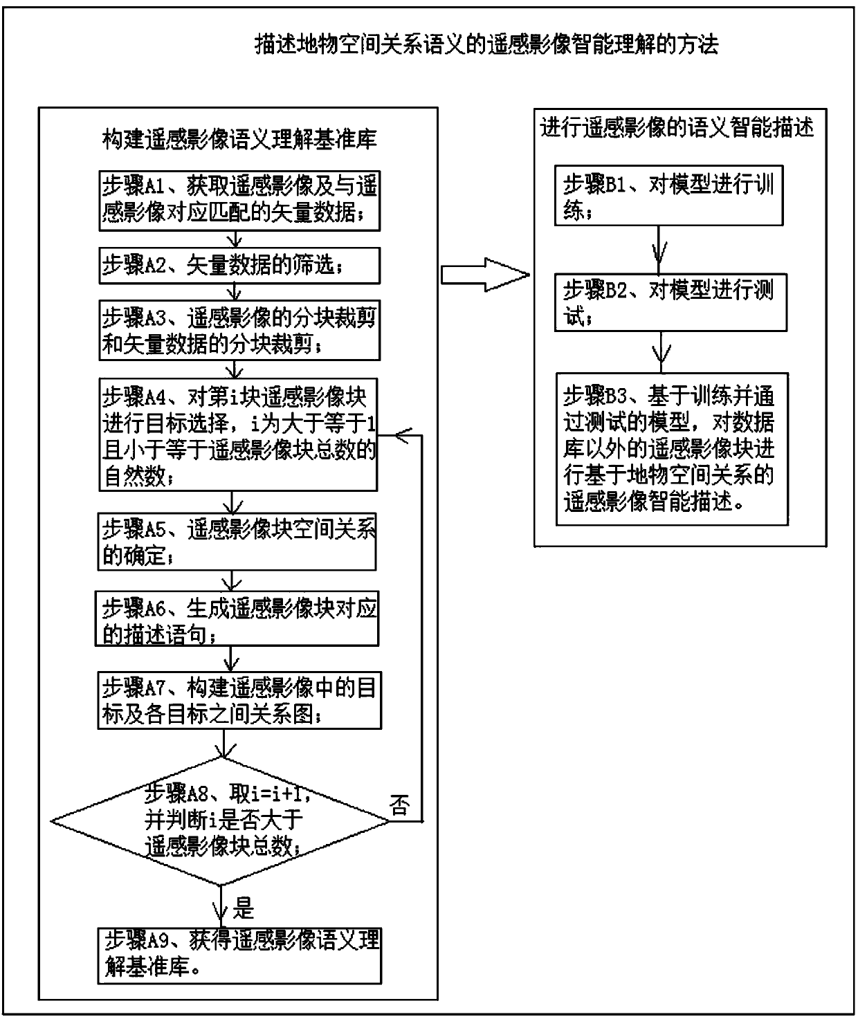
[0051] A method for intelligent understanding of remote sensing images that describes the semantics of the spatial relationship between objects, see figure 1 , including the construction of a remote sensing image semantic understanding benchmark library and the semantic intelligent description of remote sensing images. The details are:

[0052] The first part is to build a base library for advanced semantic understanding of remote sensing images, which specifically includes the following steps:

[0053] Step A1. Obtain remote sensing images and vector data corresponding to the remote sensing images, specifically by obtaining from at least one of the open-source public OSM data on the Internet, the land department, and the surveying and mapping department, such as provincial-level geographic census data;

[0054] Step A2, the screening of vector data, specifically: save the vector data that can reflect the basic types of ground features and delete the vector data that cannot r...


PUM


Abstract

The invention provides a method of intelligent remote-sensing image understanding of describing ground-object space relationship semantics. The method includes: constructing a remote-sensing image semantics understanding reference library, and carrying out intelligent semantics description of a remote-sensing image. The step of constructing the remote-sensing image semantics understanding reference library includes acquiring contents such as four parts of remote-sensing image blocks, vector data blocks corresponding to the remote-sensing image blocks, description sentences corresponding to theremote-sensing image blocks, and targets in remote-sensing images and relationship graphs among all the targets. The step of carrying out intelligent semantics description of the remote-sensing imageincludes: training a model, testing the model, and carrying out intelligent remote-sensing image description, which is based on ground-object space relationships, on a remote-sensing image block outside a database. Effects of applying the technical solution of the invention are that: understanding on the remote-sensing image is realized from different angles; the established remote-sensing imagehigh-level semantics reference library allows later further addition of description sentences corresponding to remote-sensing images, and improvement of ability of image understanding and descriptionof a computer is facilitated; and a processing method is streamlined, and realization is easy.

Description

technical field [0001] The invention relates to the technical field of intelligent semantic understanding of image vision, in particular to a method for intelligent understanding of remote sensing images describing the semantics of the spatial relationship of ground objects. Background technique [0002] Remote sensing images are an important data source for geographic information research. It is a key and urgent task to continuously obtain rich visual information and deep hidden information from remote sensing images to achieve the purpose of understanding remote sensing images. Traditional remote sensing image understanding methods are based on image processing and image analysis, starting from the surface of the image, performing feature and statistical analysis, and analyzing and processing a single feature in the image. The result is also a simple mark, recognition and detection of the feature . It cannot achieve the scene-level understanding of the content in the larg...

Claims


Application Information

Patent Timeline
Patent Type & Authority Applications(China)
IPC IPC(8): G06F17/30G06K9/00G06K9/62
CPCG06F16/51G06F16/56G06F16/583G06V20/13G06F18/214
Inventor 陈杰韩雅荣吴志祥周兴邓敏
Owner CENT SOUTH UNIV
Why Eureka
Try Eureka