A Point Cloud Data Processing Method Based on Dual Radar

A technology of point cloud data and processing methods, which is applied in the re-radiation of electromagnetic waves, instruments, measuring devices, etc., can solve the problems of low accuracy of ranging values, difficulty in obtaining accurate terrain data, etc., and achieve accurate measured distance data. , Improve the accuracy of ranging and the effect of high point cloud density

Active Publication Date: 2021-03-02
广东电网有限责任公司机巡作业中心
View PDF9 Cites 0 Cited by
  • Summary
  • Abstract
  • Description
  • Claims
  • Application Information

AI Technical Summary

Problems solved by technology

However, it is difficult to obtain accurate terrain data before using radar for measurement, so the accuracy of the final ranging value is also low

Method used


Image

  • A Point Cloud Data Processing Method Based on Dual Radar

Examples


Embodiment Construction

[0020] The present invention will be further described below with reference to the accompanying drawings. It should be noted that the accompanying drawings are only used for exemplary illustration and should not be construed as a limitation on the present patent.

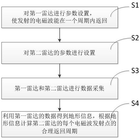
[0021] like figure 1 As shown in the figure, a method for processing point cloud data based on dual radars uses a first radar and a second radar to collect point clouds, which specifically includes the following steps:

[0022] S1: Set the electromagnetic wave emission frequency of the first radar, so that the electromagnetic wave emitted by the first radar can return to the radar within one cycle;

[0023] S2: Set the electromagnetic wave emission frequency of the second radar to the highest required emission frequency;

[0024] S3: Based on the execution of step S1 and step S2, the first radar and the second radar transmit electromagnetic waves for data collection;

[0025] S4: Process the data collected in step...


PUM


Abstract

The present invention relates to the technical field of space ranging, and more specifically, to a dual-radar-based point cloud data processing method. By using two radars to work at the same time, by setting different transmission frequencies, the first radar has a lower frequency to obtain detailed terrain information of the measurement area, and the second radar uses a higher transmission frequency for distance measurement. The information judges in which period the ultrasonic waves emitted by each emission point should return, so as to obtain accurate distance data. It solves the problem that the multi-period receiving time of electromagnetic waves in the prior art is difficult to automatically calculate; in addition, the frequency of the second radar in the present invention can be set independently according to needs, and the point cloud density obtained by a higher transmission frequency is higher. The distance data measured in the measurement area is more accurate.

Description

technical field [0001] The present invention relates to the technical field of space ranging, and more particularly, to a method for processing point cloud data based on dual radars. Background technique [0002] Radar is a device that uses electromagnetic waves to measure distances. It restores the distances of multiple measurement points to spatial coordinates, and finally realizes the spatial restoration of the surrounding environment. The time taken from electromagnetic wave emission to reception determines the accuracy of the measurement, and the number of electromagnetic waves emitted per unit time determines the data density in the point cloud. In the process of measuring the ground distance by the radar, the receiving time of electromagnetic waves has a multi-period problem due to the long distance. [0003] The radar transmits electromagnetic waves according to a given period. For the transmitting point P1 at the time of T1, the receiving time is taken as t1. If th...

Claims


Application Information

Patent Timeline
Patent Type & Authority Patents(China)
IPC IPC(8): G01S17/08
CPCG01S17/08
Inventor 许志海王年孝陈浩
Owner 广东电网有限责任公司机巡作业中心
Why Eureka
Try Eureka